Quebec Route 277
Highway in Quebec
Route 277 | ||||
|---|---|---|---|---|
 | ||||
| Route information | ||||
| Length | 101 km[1] (63 mi) | |||
| Major junctions | ||||
| South end |  R-275 in Sainte-Aurélie R-275 in Sainte-Aurélie | |||
| North end |  R-173 in St-Henri-de-Levis R-173 in St-Henri-de-Levis | |||
| Location | ||||
| Country | Canada | |||
| Province | Quebec | |||
| Major cities | Saint-Henri-de-Levis, Lac-Etchemin, Saint-Louis-de-Gonzague | |||
| Highway system | ||||
| ||||
| ||||


Route 277 is a two-lane north–south highway in the Chaudière-Appalaches region in the province of Quebec, Canada. Its northern terminus is in Saint-Henri at the junction of Route 173 and its southern terminus is in Sainte-Aurélie at the junction of Route 275.
Towns along Route 277
- Saint-Henri-de-Levis
- Saint-Anselme
- Sainte-Claire
- Saint-Malachie
- Saint-Leon de Standon
- Lac-Etchemin
- Sainte-Rose-de-Watford
- Saint-Louis-de-Gonzague
- Sainte-Aurélie
-
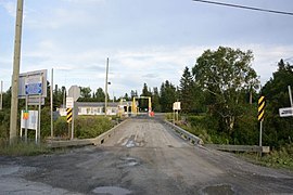 United States port of entry right off Route 277 in Sainte-Aurélie.
 -
 Route 277 along Etchemin River in Saint-Malachie.


See also
References
- ^ Ministère des transports, "Distances routières", page (?), Les Publications du Québec, 2005
External links
- Provincial Route Map (Courtesy of the Quebec Ministry of Transportation) (in French)
- Route 277 on Google Maps
- v
- t
- e
 | This Quebec road, road transport or highway-related article is a stub. You can help Wikipedia by expanding it. |
- v
- t
- e


