Greco Island
Island in California, United States
37°31′04″N 122°10′59″W / 37.5177146°N 122.1830205°W / 37.5177146; -122.1830205[1]Greco Island[1] is a wetland island in Redwood City, California. Greco Island is part of the larger Don Edwards San Francisco Bay National Wildlife Refuge. Westpoint Slough follows the South side of the island while Redwood Creek is along the West. The San Francisco Bay bounds the North and East sides of the island.
History
Greco Island was named after a longtime resident of the island who lived there until he died of a stroke. The Bank of Italy, to whom the land had been mortgaged, then sold it to the Leslie Salt Company.[3]
San Mateo County plans from 1969 called for continued development of the Port of Redwood City area with recreational facilities by acquiring the land on Greco Island.[4]
Greco Island was one of the first areas along with Fremont, Mowry Slough, and Alviso to be included in a proposal for The San Francsico Bay National Wildlife Refuge in 1972.[5]
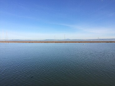
In 2007 a report on the shoreline of the island determined that it was composed of fine sediment forming extensive mudflats that are submerged during high tide. This shore is sensitive to erosion from waves and nearby marine traffic and of concern if traffic were to increase.[6] The waters bordering Greco are frequently traveled by vessels from both the Port of Redwood City and Westpoint Harbor.
In more recent years concerns over sea level rising have encouraged more active recovery of marshland in the bay including the areas surrounding the island.[7]
Wildlife
The endangered Salt marsh harvest mouse is one of many species that lives upon Greco Island.[5]
A pair of Short-eared owls was confirmed living on the island in 1994.[8]
Harbor seals in the bay visit the island for their hauling-out.[9]
Another endangered animal, the California clapper rail uses Greco Island and nearby Westpoint Slough as a habitat.[10]
Gallery
|


See also
 San Francisco Bay Area portal

- Bair Island
- Mowry Slough
- Westpoint Harbor
References
- ^ a b "Greco Island". Geographic Names Information System. United States Geological Survey, United States Department of the Interior. 19 January 1981. Retrieved 29 December 2016.
- ^ HydroPlan LLC (June 2015). "Draft Integrated Feasibility Report and Environmental Impact" (PDF). US Army Corps of Engineers. pp. 2–17. Retrieved 4 January 2017.
- ^ Terremere, Alice; Demma, Philip (May 1982). An interview with Leonard Dalve. Redwood City, California: Redwood City Archives Committee. pp. 2-4. Retrieved 4 January 2017.
- ^ Port of Redwood City Levee Project: Environmental Impact Statement. US Army Corps of Engineers. June 1975. p. 30. Retrieved 4 January 2017.
- ^ a b "Appendix P. Response to Comments" (PDF). US Fish and Wildlife Service. Retrieved 4 January 2017.
- ^ "Preliminary Wake Wash Impact Analysis Redwood City Ferry Terminal" (PDF). Redwood City Port. Coast and Harbor Engineering. 1 April 2007. Retrieved 4 January 2017.
- ^ Kelly, Kevin (4 November 2015). "Menlo Park: As the sea rises so should the urgency to tackle the problem locally, officials agree". San Jose Mercury News. Retrieved 4 January 2017.
- ^ Bair Island Restoration and Management Plan: Final EIS/EIR. California Department of Fish and Game. June 2006. p. 36. Retrieved 4 January 2017.
- ^ Fox, Kathlyn Snyder (December 2008). Harbor seal behavioral response to boaters at Bair Island refuge (MS thesis). San Jose State University. doi:10.31979/etd.qkp6-eha5. ISBN 978-1-109-07546-5. ProQuest 304825168. Retrieved 4 January 2017 – via SJSU ScholarWorks.
- ^ Spautz, Hildie; McBroom, Jennifer (31 October 2006). "California Clapper Rail Surveys for the San Francisco Estuary" (PDF). SF Invasive Spartina Project. California Coastal Conservancy. Retrieved 5 January 2017.
External links
Wikimedia Commons has media related to Greco Island.
- US HR Law 92-330
- v
- t
- e
San Mateo County, California, United States
- Cañada College
- Marine Science Institute
- Peninsula Library System
- Port of Redwood City
- Redwood Creek
- Don Edwards San Francisco Bay National Wildlife Refuge
- Bair Island
- Greco Island
- Fox Theatre
- Historic Commercial District
- Lathrop House
- San Mateo County History Museum
- Union Cemetery
 Category
Map: Islands of the San Francisco Bay Area | |
|---|---|
  Alameda Alcatraz Angel Bair Bay Farm Belvedere Bird I. Brooks The Brothers  Castro Rocks Coast Guard Corinthian Greco Gull R. Hog Hooks  Kent (off map) Mare Mussel Rock Rat Rock Red R. San Pedro Rock Seal Rocks Seal Rock The Sisters Treasure Marin Yerba Buena Skaggs Strawberry Drawbridge Brewer  Bull (off map) Burdell Coon Day Deer Edgerly Green #1 #2 Knight Little Neils Russ Tubbs Wood Bird Aramburu Ogilvie Silva Simms Jakes Newby Richardson |


