Clipper Mountain Wilderness

Wilderness area in California, United States
34°44′17″N 115°25′03″W / 34.73805°N 115.41759°W / 34.73805; -115.41759Area33,843 acres (13,696 ha)Governing bodyU.S. Bureau of Land Management

The Clipper Mountain Wilderness is a wilderness area in the Clipper Mountains of the eastern Mojave Desert and within Mojave Trails National Monument, located in northeastern San Bernardino County, California.[1][2] It is under the jurisdiction of the Bureau of Land Management.[1]

Geography

The 33,843-acre (13,696 ha) Clipper Mountain Wilderness is found mostly on the northern section of the Clipper Mountains, which are adjacent on the north to Interstate 40 and historic U.S. Route 66. The wilderness area is adjoining the southern National Park Service Mojave National Preserve. It is 50 miles west of Needles, California.[3]

Description

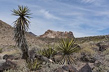
The Clipper Mountain Wilderness has rugged yellow and dark brown, horizontally striped mesas, narrow canyons with springs, and sparsely vegetated alluvial fans. The small cluster of volcanic mountains is oriented northeast to southwest. In the center, the most prominent ridge, Clipper Mountain, reaches an elevation of 4,625 feet before it dramatically drops off in series of sharp cliffs overlooking the Fenner and Clipper Valleys. Castle Dome, a local landmark, can be clearly seen from Historic Route 66.[1]

Natural history

Flora

See: Category: Flora of the California desert regions

The plant community vegetation types here are predominantly Creosote bush (Larrea tridentata) xeric desert scrub and desert wash scrub habitats. In the spring, the alluvial fans turn yellow with Brittlebush - Encelia farinosa and other desert wildflowers.[1]

Fauna

See: Category: Fauna of the Mojave Desert

Wildlife in the wilderness area is typical for the Mojave Desert; including a herd of 40-50 desert bighorn sheep, coyotes, black-tailed jackrabbits, Mohave ground squirrels, kangaroo rats, greater roadrunners, chukar, quail, prairie falcons, red-tailed hawks, golden eagles, rattlesnakes, and several species of lizards including the zebra-tailed lizard. The entire wilderness is considered critical habitat for the threatened desert tortoise.[1]

See also

Wikimedia Commons has media related to Clipper Mountain Wilderness.

References

  1. ^ a b c d e "Clipper Mountain Wilderness". Bureau of Land Management. Archived from the original on 2011-10-12. Retrieved 2011-08-11.
  2. ^ U.S. Dept. of Interior.gov: Map of Mojave Trails National Monument Archived 2016-03-16 at the Wayback Machine, with Wilderness Areas.
  3. ^ "Clipper Mountain Wilderness Map" (PDF). Bureau of Land Management. Archived from the original (PDF) on 2012-10-19. Retrieved 2011-08-11.

External links

  • "Clipper Mountain Wilderness". Bureau of Land Management. Archived from the original on 2011-10-12. Retrieved 2011-08-11.
  • "Clipper Mountain Wilderness Map" (PDF). Bureau of Land Management. Archived from the original (PDF) on 2012-10-19. Retrieved 2011-08-11.
  • "Photos of Clipper Mountain Wilderness Area". Bureau of Land Management. Archived from the original on 2011-06-14. Retrieved 2011-08-11.
  • v
  • t
  • e
Parks
Preserves
Monuments
Seashores
Historical Parks
Historic Sites
Memorials
Recreation Areas
Parks
Natural Reserves
Marine Reserves
Historic Parks
Beaches
Recreation Areas
Vehicular
Recreation Areas
Other
National Forests and Grasslands
National Forests
and Grasslands
National Wilderness
Preservation System
National Monuments
and Recreation Areas
Wildlife
Areas
  • Antelope Valley
  • Ash Creek
  • Bass Hill
  • Battle Creek
  • Big Lagoon
  • Big Sandy
  • Biscar
  • Butte Valley
  • Buttermilk Country
  • Cache Creek
  • Camp Cady
  • Cantara/Ney Springs
  • Cedar Roughs
  • Cinder Flats
  • Collins Eddy
  • Colusa Bypass
  • Coon Hollow
  • Cottonwood Creek
  • Crescent City Marsh
  • Crocker Meadows
  • Daugherty Hill
  • Decker Island
  • Doyle
  • Dutch Flat
  • Eastlker River
  • Eel River
  • Elk Creek Wetlands
  • Elk River
  • Fay Slough
  • Feather River
  • Fitzhugh Creek
  • Fremont Weir
  • Grass Lake
  • Gray Lodge
  • Green Creek
  • Grizzly Island
  • Hallelujah Junction
  • Heenan Lake
  • Hill Slough
  • Hollenbeck Canyon
  • Honey Lake
  • Hope Valley
  • Horseshoe Ranch
  • Imperial
  • Indian Valley
  • Kelso Peak and Old Dad Mountains
  • Kinsman Flat
  • Knoxville
  • Laguna
  • Lake Berryessa
  • Lake Earl
  • Lake Sonoma
  • Little Panoche Reservoir
  • Los Banos
  • Lower Sherman Island
  • Mad River Slough
  • Marble Mountains
  • Mendota
  • Merrill's Landing
  • Miner Slough
  • Monache Meadows
  • Morro Bay
  • Moss Landing
  • Mouth of Cottonwood Creek
  • Napa-Sonoma Marshes
  • North Grasslands
  • O'Neill Forebay
  • Oroville
  • Petaluma Marsh
  • Pickel Meadow
  • Pine Creek
  • Point Edith
  • Putah Creek
  • Rector Reservoir
  • Red Lake
  • Rhode Island
  • Sacramento River
  • San Felipe Valley
  • San Jacinto
  • San Luis Obispo
  • San Luis Reservoir
  • San Pablo Bay
  • Santa Rosa
  • Shasta Valley
  • Silver Creek
  • Slinkard/Little Antelope
  • Smithneck Creek
  • South Fork
  • Spenceville
  • Surprise Valley
  • Sutter Bypass
  • Tehama
  • Truckee River
  • Upper Butte Basin
  • Volta
  • Warner Valley
  • Waukell Creek
  • West Hilmar
  • Westlker River
  • White Slough
  • Willow Creek
  • Yolo Bypass
Ecological
Reserves
Marine
Protected
Areas
National Monuments
National
Conservation Areas
  • California Desert
  • King Range
Wilderness Areas
Heritage registers
National Natural Landmarks


Stub icon

This San Bernardino County, California–related article is a stub. You can help Wikipedia by expanding it.

  • v
  • t
  • e
Stub icon

This article related to a protected area in California is a stub. You can help Wikipedia by expanding it.

  • v
  • t
  • e