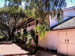
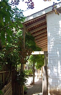
Castro Adobe

Historic house in California, United States
United States historic place
Jose Joaquin Castro Adobe
California Historical Landmark No. 998
36°56′46″N 121°48′40″W / 36.94611°N 121.81111°W / 36.94611; -121.81111
Arealess than one acre
Built1848–1849
ArchitectJosé Joaquín Castro
Architectural styleMonterey Colonial
NRHP reference No.76000531[1]
CHISL No.998
Added to NRHPDecember 12, 1976

The Rancho San Andrés Castro Adobe is a historically and architecturally significant house located in the Pájaro Valley, California. The two-story Rancho San Andrés Castro Adobe is a historic rancho hacienda that was built between 1848 and 1849.[2]

History

Photograph from the 1930s of the Historic American Buildings Survey (photographer unknown).

The house was built in 1848–1849 by Juan José Castro. His father Jose Joaquin Castro (1768–1838), came to California as a 6-year-old with his family from Sinaloa Mexico on the 1775–1776 Anza Expedition. Jose Joaquín Castro received this Mexican land grant Rancho San Andrés in the area of present-day Watsonville, California. It had the first dance floor (fandango room) in Santa Cruz County, California and one of the first indoor kitchens (cocina). It is the only two-story hacienda ever built in Santa Cruz County.[3]

The house was added to the National Register of Historic Places listings in Santa Cruz County, California on December 12, 1976.[1] It is California Historical Landmark number 998.[4] The adobe was severely damaged in the 1989 Loma Prieta earthquake. One wall had completely collapsed, and the house needed seismic retrofitting before being safe for the public. Owner Edna Kimbro sold it to the state of California in 2002. Starting in August 2007, Friends of California State Parks volunteers and the California Conservation Corps began restoration by making 2500 adobe bricks.[5]

Almost 100 members of the Castro family held a reunion at the site in 2008.[6] As of September 2015[update] it was not yet opened to the public as a state park, but it is expected to open in 2016 as Rancho San Andres Castro Adobe Historic State Park.[7][needs update]

The Castro Adobe in 2012.

References

  1. ^ a b "National Register Information System". National Register of Historic Places. National Park Service. March 13, 2009.
  2. ^ "Rancho San Andrés Castro Adobe". California Department of Parks and Recreation. Retrieved 7 July 2022.
  3. ^ Todd Guild (January 16, 2010). "Castro Adobe taking shape". Watsonville Register-Pajaronian. Archived from the original on July 15, 2011. Retrieved May 22, 2010.
  4. ^ "California Historical Landmark: Santa Cruz County". Office of Historic Preservation. California State Parks. Retrieved 2012-10-14.
  5. ^ Todd Guild (August 31, 2007). "Volunteers make 2,500 bricks from dirt, water and straw for Castro Adobe". Watsonville Register-Pajaronian. Archived from the original on July 15, 2011. Retrieved May 22, 2010.
  6. ^ Tarmo Hannula (October 13, 2008). "Castros reunite at historic adobe home". Watsonville Register-Pajaronian. Archived from the original on June 14, 2015. Retrieved June 4, 2015.
  7. ^ "Castro Adobe Park Property". California State Parks Official web site. Archived from the original on September 26, 2011. Retrieved September 4, 2011.

External links

  • Office of Historic Preservation — entry #998
  • Friends of Santa Cruz State Parks — website on the Castro Adobe
  • Chronicling the Castro Adobe — a restoration blog
  • v
  • t
  • e
National Park System
Parks
Preserves
Monuments
Seashores
Historical Parks
Historic Sites
Memorials
Recreation Areas
Parks
Natural Reserves
Marine Reserves
Historic Parks
Beaches
Recreation Areas
Vehicular
Recreation Areas
Other
National Forests and Grasslands
National Forests
and Grasslands
National Wilderness
Preservation System
National Monuments
and Recreation Areas
Wildlife
Areas
  • Antelope Valley
  • Ash Creek
  • Bass Hill
  • Battle Creek
  • Big Lagoon
  • Big Sandy
  • Biscar
  • Butte Valley
  • Buttermilk Country
  • Cache Creek
  • Camp Cady
  • Cantara/Ney Springs
  • Cedar Roughs
  • Cinder Flats
  • Collins Eddy
  • Colusa Bypass
  • Coon Hollow
  • Cottonwood Creek
  • Crescent City Marsh
  • Crocker Meadows
  • Daugherty Hill
  • Decker Island
  • Doyle
  • Dutch Flat
  • Eastlker River
  • Eel River
  • Elk Creek Wetlands
  • Elk River
  • Fay Slough
  • Feather River
  • Fitzhugh Creek
  • Fremont Weir
  • Grass Lake
  • Gray Lodge
  • Green Creek
  • Grizzly Island
  • Hallelujah Junction
  • Heenan Lake
  • Hill Slough
  • Hollenbeck Canyon
  • Honey Lake
  • Hope Valley
  • Horseshoe Ranch
  • Imperial
  • Indian Valley
  • Kelso Peak and Old Dad Mountains
  • Kinsman Flat
  • Knoxville
  • Laguna
  • Lake Berryessa
  • Lake Earl
  • Lake Sonoma
  • Little Panoche Reservoir
  • Los Banos
  • Lower Sherman Island
  • Mad River Slough
  • Marble Mountains
  • Mendota
  • Merrill's Landing
  • Miner Slough
  • Monache Meadows
  • Morro Bay
  • Moss Landing
  • Mouth of Cottonwood Creek
  • Napa-Sonoma Marshes
  • North Grasslands
  • O'Neill Forebay
  • Oroville
  • Petaluma Marsh
  • Pickel Meadow
  • Pine Creek
  • Point Edith
  • Putah Creek
  • Rector Reservoir
  • Red Lake
  • Rhode Island
  • Sacramento River
  • San Felipe Valley
  • San Jacinto
  • San Luis Obispo
  • San Luis Reservoir
  • San Pablo Bay
  • Santa Rosa
  • Shasta Valley
  • Silver Creek
  • Slinkard/Little Antelope
  • Smithneck Creek
  • South Fork
  • Spenceville
  • Surprise Valley
  • Sutter Bypass
  • Tehama
  • Truckee River
  • Upper Butte Basin
  • Volta
  • Warner Valley
  • Waukell Creek
  • West Hilmar
  • Westlker River
  • White Slough
  • Willow Creek
  • Yolo Bypass
Ecological
Reserves
Marine
Protected
Areas
National Monuments
National
Conservation Areas
  • California Desert
  • King Range
Wilderness Areas
Heritage registers
National Natural Landmarks
Authority control databases Edit this at Wikidata
  • VIAF


Stub icon

This article about a property in Santa Cruz County, California on the National Register of Historic Places is a stub. You can help Wikipedia by expanding it.

  • v
  • t
  • e