Zottegem
City and municipality in Flemish Community, Belgium

Flag

Coat of arms
Location of Zottegem


Zottegem
Location in Belgium 
Location of Zottegem in East Flanders

 Belgium
 (2018-01-01)[1]
9620
41081
Zottegem (Dutch pronunciation: [ˈzɔtəɣɛm], Sotteghem and Sottegem in older English and French language sources) is a city and municipality located in Belgium and more particularly in Flanders, in the province of East Flanders. The municipality comprises the town of Zottegem proper and the villages of Elene, Erwetegem, Godveerdegem, Grotenberge, Leeuwergem, Oombergen, Sint-Goriks-Oudenhove, Sint-Maria-Oudenhove, Strijpen and Velzeke-Ruddershove. On 1 January 2018, Zottegem had a total population of 26,373. The total area is 56.66 km2 which gives a population density of 470 inhabitants per km2.[2]
Zottegem is part of the hilly geographical area of the Flemish Ardennes (Vlaamse Ardennen); the hills and cobblestone streets (Paddestraat) are regular locations in the springtime cycle classics of Flanders.
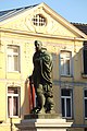
The city is known for its ties with Lamoral, Count of Egmont. Lamoral has an Egmont Castle (Egmontkasteel), an Egmont museum (Egmontkamer) and two Egmont statues in the centre of Zottegem. He is buried in Egmont's crypt (Egmontcrypte) under the church.
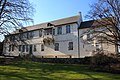
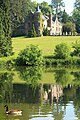
Leeuwergem Castle in Elene is an 18th-century stately home. There also the ruins of an 18th-century windmill can be found.[3] Breivelde Castle in Grotenberge is surrounded by an English landscape garden. The archaeological museum of Velzeke exhibits findings from Gallo-Roman culture.
Places of interest
-
![Church of the Assumption of Our Lady [nl], Egmont's crypt](//upload.wikimedia.org/wikipedia/commons/thumb/a/a7/Markt_met_Egmontstandbeeld_en_Onze-Lieve-Vrouw-Hemelvaartkerk%2C_Zottegem.jpg/120px-Markt_met_Egmontstandbeeld_en_Onze-Lieve-Vrouw-Hemelvaartkerk%2C_Zottegem.jpg) Church of the Assumption of Our Lady [nl], Egmont's crypt
Church of the Assumption of Our Lady [nl], Egmont's crypt -
-
-

-
-

-

-

![Church of the Assumption of Our Lady [nl], Egmont's crypt](http://upload.wikimedia.org/wikipedia/commons/thumb/a/a7/Markt_met_Egmontstandbeeld_en_Onze-Lieve-Vrouw-Hemelvaartkerk%2C_Zottegem.jpg/120px-Markt_met_Egmontstandbeeld_en_Onze-Lieve-Vrouw-Hemelvaartkerk%2C_Zottegem.jpg)


Famous inhabitants
- Urbain Braems, football player and manager, lived in Zottegem
- Bart De Clercq, cyclist
- Patricia de Martelaere (b. in Zottegem), writer
- Anne De Paepe [nl], former rector of Ghent University
- Jessy De Smet, singer
- Lamoral, Count of Egmont, general and statesman, is buried in Zottegem
- Tim Matthys, football player, lives in Zottegem
- Laurent Merchiers, politician
- Lyne Renée (b. in Zottegem), actress
- Paul Van Cauwenberge, former rector of Ghent University
- Magali Uytterhaegen [nl] (b. in Zottegem), actress (The curiosity of Chance)
See also
- Zwalm (River)
References
External links
 Media related to Zottegem at Wikimedia Commons
- Official website - Information available in Dutch and limited information available in English, French and German
Places adjacent to Zottegem | ||||||||||||||||
|---|---|---|---|---|---|---|---|---|---|---|---|---|---|---|---|---|
| ||||||||||||||||


- v
- t
- e
Belgian municipality Zottegem
- Elene [nl]
- Erwetegem
- Godveerdegem
- Grotenberge
- Leeuwergem
- Oombergen [nl]
- Sint-Goriks-Oudenhove
- Sint-Maria-Oudenhove
- Strijpen [nl]
- Velzeke-Ruddershove
- Zottegem
 Category
- Commons
 Belgium Portal


| ||
|---|---|---|
| Aalst |  | |
| Dendermonde | ||
| Eeklo | ||
| Ghent | ||
| Oudenaarde | ||
| Sint-Niklaas | ||
| ||
Authority control databases | |
|---|---|
| International |
|
| National |
|
| Geographic |
|
 | This East Flanders location article is a stub. You can help Wikipedia by expanding it. |
- v
- t
- e


