Kaprijke
Municipality in Flemish Community, Belgium

Flag

Coat of arms
Location of Kaprijke


Kaprijke
Location in Belgium 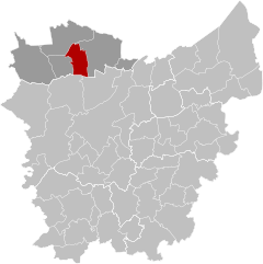
Location of Kaprijke in East Flanders

 Belgium
 (2018-01-01)[1]
9970, 9971
43007

Kaprijke (Dutch pronunciation: [ˈkɑprɛi̯kə]) is a municipality in the Belgian province of East Flanders. The municipality comprises the towns of Kaprijke proper and Lembeke [nl]. In 2021, Kaprijke had a total population of 6,508.[2]
History
The name Kaprijke comes from Gallo-Roman name "Capricum" which means "Land of Caprius". It used to be the site of a Roman garrison, which can still be seen at the square in front of the old town hall. Kaprijke received city rights in 1240 by Joan, Countess of Flanders.[3]
During the 14th and 15th century, the cloth industry flourished in Kaprijke. However, during the period of religious strife during the 16th century, the merchants and cloth makers withdrew to safer locations. Following the resolution of the problems, the merchants and weavers did not return, leading up to the decline of the city of Kaprijke into a rural village during the 17th and 18th centuries.
Kaprijke is known for its beautiful castle built in 1550, Hof ter Kruisen. It was commissioned by Andries of Baviere and finished in 1628.
In 1976, Kaprijke merged with another town called Lembeke, for a total population of around 6,200 people.
Lembeke is the home of Lotus Bakeries.[4] The Bardelaere Museum is located in Lembeke.
Famous inhabitants
- Roger De Vlaeminck, cyclist, amongst other four times winner of Paris–Roubaix
- Hippoliet Van Peene (1811–1864), poet and playwright, best known for writing the poem "De Vlaamse Leeuw" which came to be the Flemish anthem.
Gallery
-
 Kaprijke is divided into two towns. 1: Kaprijke proper and 2:Lembeke
 -
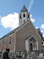 Kaprijke, church: parochiekerk Onze Lieve Vrouw Hemelvaart
 -
 Lembeke, church: parochiekerk Sint Egidius


References
External links
 Media related to Kaprijke at Wikimedia Commons
- Kaprijke (Official website)
Places adjacent to Kaprijke | ||||||||||||||||
|---|---|---|---|---|---|---|---|---|---|---|---|---|---|---|---|---|
| ||||||||||||||||


- v
- t
- e

- Assenede
- Eeklo
- Kaprijke
- Maldegem
- Sint-Laureins
- Zelzate
- Bold indicates cities
- Italic indicates municipality with language facilities
Authority control databases | |
|---|---|
| International |
|
| National |
|
| Geographic |
|


