Tuần Giáo district
You can help expand this article with text translated from the corresponding article in Vietnamese. (March 2009) Click [show] for important translation instructions.
- View a machine-translated version of the Vietnamese article.
- Machine translation, like DeepL or Google Translate, is a useful starting point for translations, but translators must revise errors as necessary and confirm that the translation is accurate, rather than simply copy-pasting machine-translated text into the English Wikipedia.
- Do not translate text that appears unreliable or low-quality. If possible, verify the text with references provided in the foreign-language article.
- You must provide copyright attribution in the edit summary accompanying your translation by providing an interlanguage link to the source of your translation. A model attribution edit summary is
Content in this edit is translated from the existing Vietnamese Wikipedia article at [[:vi:Tuần Giáo]]; see its history for attribution. - You may also add the template
{{Translated|vi|Tuần Giáo}}to the talk page. - For more guidance, see Wikipedia:Translation.
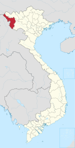
District in Northwest, Vietnam
Tuần Giáo District Huyện Tuần Giáo | |
|---|---|
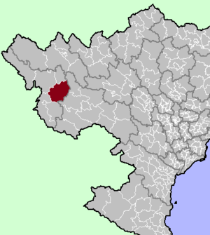 District location in northern Vietnam | |
| Country |  Vietnam Vietnam |
| Region | Northwest |
| Province | Điện Biên |
| Capital | Tuần Giáo |
| Area | |
| • Total | 438.72 sq mi (1,136.29 km2) |
| Population (2006) | |
| • Total | 71,423 |
| • Density | 160/sq mi (63/km2) |
| Time zone | UTC+07:00 (Indochina Time) |
Tuần Giáo is a rural district of Điện Biên province in the Northwest region of Vietnam. As of 2006, the district had a population of 71,423.[1] The district covers an area of 1,136.29 km². The district capital lies at Tuần Giáo.[1]
On 24 June 1983, a 6.7 earthquake occurred in Tuần Giáo at around 14:00 local time, 11 km northeast of Tuần Giáo townlet, causing heavy losses to the Tuần Giáo district and surrounding areas. After the event, a series of aftershocks occurred, with the largest occurring on 15 July 1983 with a magnitude of 5.4.[2]
In 2006, a portion of the district was carved out to form Mường Ảng district.
Administrative divisions
Tuan Giao has 14 administrative units, including 1 town and 13 communes:
Climate
| Climate data for Tuần Giáo, elevation 570 m (1,870 ft) | |||||||||||||
|---|---|---|---|---|---|---|---|---|---|---|---|---|---|
| Month | Jan | Feb | Mar | Apr | May | Jun | Jul | Aug | Sep | Oct | Nov | Dec | Year |
| Record high °C (°F) | 31.0 (87.8) | 36.3 (97.3) | 36.8 (98.2) | 38.8 (101.8) | 37.4 (99.3) | 36.6 (97.9) | 36.3 (97.3) | 36.4 (97.5) | 36.4 (97.5) | 35.1 (95.2) | 34.0 (93.2) | 31.4 (88.5) | 38.8 (101.8) |
| Mean daily maximum °C (°F) | 22.4 (72.3) | 24.7 (76.5) | 28.1 (82.6) | 30.6 (87.1) | 31.1 (88.0) | 30.6 (87.1) | 30.2 (86.4) | 30.4 (86.7) | 30.2 (86.4) | 28.4 (83.1) | 25.5 (77.9) | 22.9 (73.2) | 27.9 (82.2) |
| Daily mean °C (°F) | 15.1 (59.2) | 16.8 (62.2) | 19.9 (67.8) | 23.0 (73.4) | 24.8 (76.6) | 25.4 (77.7) | 25.3 (77.5) | 25.1 (77.2) | 24.2 (75.6) | 22.0 (71.6) | 18.7 (65.7) | 15.4 (59.7) | 21.3 (70.3) |
| Mean daily minimum °C (°F) | 11.1 (52.0) | 12.1 (53.8) | 14.7 (58.5) | 18.3 (64.9) | 21.0 (69.8) | 22.6 (72.7) | 22.6 (72.7) | 22.3 (72.1) | 20.9 (69.6) | 18.5 (65.3) | 15.0 (59.0) | 11.6 (52.9) | 17.6 (63.7) |
| Record low °C (°F) | −0.6 (30.9) | 2.7 (36.9) | 4.1 (39.4) | 10.3 (50.5) | 13.9 (57.0) | 14.3 (57.7) | 19.0 (66.2) | 17.1 (62.8) | 11.5 (52.7) | 7.7 (45.9) | 3.6 (38.5) | −0.4 (31.3) | −0.6 (30.9) |
| Average precipitation mm (inches) | 26.7 (1.05) | 25.9 (1.02) | 58.7 (2.31) | 135.6 (5.34) | 216.8 (8.54) | 286.3 (11.27) | 316.7 (12.47) | 276.3 (10.88) | 137.8 (5.43) | 65.8 (2.59) | 40.5 (1.59) | 25.7 (1.01) | 1,612.9 (63.50) |
| Average rainy days | 4.8 | 4.2 | 6.5 | 13.2 | 17.4 | 21.3 | 23.2 | 21.2 | 13.7 | 8.9 | 5.8 | 3.9 | 144.4 |
| Average relative humidity (%) | 82.6 | 79.5 | 77.8 | 79.5 | 81.8 | 85.1 | 86.3 | 86.8 | 85.9 | 84.8 | 84.6 | 83.8 | 83.2 |
| Mean monthly sunshine hours | 141.8 | 152.0 | 178.3 | 199.0 | 193.2 | 132.4 | 132.7 | 149.5 | 162.4 | 158.8 | 150.1 | 145.9 | 1,896.3 |
| Source: Vietnam Institute for Building Science and Technology[3] | |||||||||||||
| Climate data for Pha Din, elevation 1,347 m (4,419 ft) | |||||||||||||
|---|---|---|---|---|---|---|---|---|---|---|---|---|---|
| Month | Jan | Feb | Mar | Apr | May | Jun | Jul | Aug | Sep | Oct | Nov | Dec | Year |
| Record high °C (°F) | 29.3 (84.7) | 31.8 (89.2) | 36.0 (96.8) | 36.5 (97.7) | 36.6 (97.9) | 35.5 (95.9) | 36.0 (96.8) | 33.8 (92.8) | 32.6 (90.7) | 31.4 (88.5) | 31.2 (88.2) | 29.1 (84.4) | 36.6 (97.9) |
| Mean daily maximum °C (°F) | 17.2 (63.0) | 19.6 (67.3) | 22.7 (72.9) | 25.0 (77.0) | 25.2 (77.4) | 24.6 (76.3) | 24.2 (75.6) | 24.5 (76.1) | 24.2 (75.6) | 22.4 (72.3) | 19.7 (67.5) | 17.1 (62.8) | 22.2 (72.0) |
| Daily mean °C (°F) | 12.5 (54.5) | 14.5 (58.1) | 17.7 (63.9) | 20.0 (68.0) | 20.7 (69.3) | 20.8 (69.4) | 20.6 (69.1) | 20.6 (69.1) | 20.0 (68.0) | 18.1 (64.6) | 15.2 (59.4) | 12.4 (54.3) | 17.7 (63.9) |
| Mean daily minimum °C (°F) | 9.8 (49.6) | 11.3 (52.3) | 14.3 (57.7) | 16.6 (61.9) | 17.9 (64.2) | 18.7 (65.7) | 18.7 (65.7) | 18.6 (65.5) | 17.7 (63.9) | 15.8 (60.4) | 12.7 (54.9) | 10.0 (50.0) | 15.2 (59.4) |
| Record low °C (°F) | −0.4 (31.3) | 0.1 (32.2) | −0.1 (31.8) | 5.9 (42.6) | 11.0 (51.8) | 13.1 (55.6) | 14.0 (57.2) | 15.0 (59.0) | 10.9 (51.6) | 8.3 (46.9) | 4.2 (39.6) | −1.2 (29.8) | −1.2 (29.8) |
| Average rainfall mm (inches) | 26.0 (1.02) | 30.3 (1.19) | 64.1 (2.52) | 133.8 (5.27) | 222.9 (8.78) | 305.3 (12.02) | 359.6 (14.16) | 324.8 (12.79) | 168.6 (6.64) | 71.7 (2.82) | 44.1 (1.74) | 26.0 (1.02) | 1,784.3 (70.25) |
| Average rainy days | 5.7 | 5.4 | 7.5 | 13.7 | 17.9 | 22.0 | 24.4 | 22.3 | 15.6 | 10.1 | 6.8 | 4.6 | 155.9 |
| Average relative humidity (%) | 81.4 | 75.8 | 71.1 | 75.5 | 83.0 | 89.7 | 91.4 | 90.5 | 86.9 | 86.0 | 83.9 | 81.9 | 83.2 |
| Mean monthly sunshine hours | 179.7 | 172.6 | 205.9 | 213.4 | 192.5 | 119.7 | 125.6 | 140.5 | 162.4 | 164.9 | 162.7 | 180.9 | 2,019.9 |
| Source: Vietnam Institute for Building Science and Technology[4] | |||||||||||||
References
21°40′01″N 103°19′59″E / 21.667°N 103.333°E / 21.667; 103.333
- v
- t
- e
Capital: Điện Biên Phủ
- Wards
- Him Lam
- Mường Thanh
- Nam Thanh
- Noong Bua
- Tân Thanh
- Thanh Bình
- Thanh Trường
- Communes
- Mường Phăng
- Nà Nhạn
- Nà Tấu
- Pá Khoang
- Thanh Minh
- Hẹ Muông
- Hua Thanh
- Mường Lói
- Mường Nhà
- Mường Pồn
- Na Tông
- Na Ư
- Noọng Hẹt
- Noong Luống
- Núa Ngam
- Pa Thơm
- Phu Luông
- Pom Lót
- Sam Mứn
- Thanh An
- Thanh Chăn
- Thanh Hưng
- Thanh Luông
- Thanh Nưa
- Thanh Xương
- Thanh Yên
- Mường Ảng
- Ẳng Cang
- Ẳng Nưa
- Ẳng Tở
- Búng Lao
- Mường Đăng
- Mường Lạn
- Nặm Lịch
- Ngối Cáy
- Xuân Lao
- Mường Chà
- Huổi Lèng
- Huổi Mí
- Hừa Ngài
- Ma Thì Hồ
- Mường Mươn
- Mường Tùng
- Na Sang
- Nậm Nèn
- Pa Ham
- Sa Lông
- Sá Tổng
- Tuần Giáo
- Chiềng Đông
- Chiềng Sinh
- Mường Khong
- Mường Mùn
- Mường Thín
- Nà Sáy
- Nà Tòng
- Phình Sáng
- Pú Nhung
- Pú Xi
- Quài Cang
- Quài Nưa
- Quài Tở
- Rạng Đông
- Ta Ma
- Tênh Phông
- Tỏa Tình
- Mùn Chung
Districts of Northwest Vietnam | ||
|---|---|---|
| Điện Biên province |
|  |
| Hòa Bình province | ||
| Lai Châu province | ||
| Lào Cai province | ||
| Sơn La province | ||
| Yên Bái province | ||
※ denotes provincial seat. | ||
 | This article about a location in Điện Biên province, Vietnam is a stub. You can help Wikipedia by expanding it. |
- v
- t
- e


