San Basilio, Sardinia
Comune in Sardinia, Italy
San Basilio Santu 'Asili 'e Monti | |
|---|---|
Comune | |
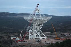 The Sardinia Radio Telescope (SRT) under construction | |
Location of San Basilio  | |
39°32′N 9°12′E / 39.533°N 9.200°E / 39.533; 9.200 | |
| Country | Italy |
| Region | Sardinia |
| Province | South Sardinia |
| Area | |
| • Total | 44.9 km2 (17.3 sq mi) |
| Population (December 2004)[1] | |
| • Total | 1,371 |
| • Density | 31/km2 (79/sq mi) |
| Time zone | UTC+1 (CET) |
| • Summer (DST) | UTC+2 (CEST) |
| Postal code | 09040 |
| Dialing code | 070 |
San Basilio (Sardinian: Santu 'Asili 'e Monti) is a commune in the Province of South Sardinia, region of Sardinia, Italy, about 35 km (22 mi) north of Cagliari. As of 31 December 2004, it has a population of 1,371 and an area of 44.9 km2 (17.3 sq mi).[2]
San Basilio borders the municipalities of San Nicolò Gerrei, Sant'Andrea Frius, Senorbì, Silius, and Siurgus Donigala.
Demographic evolution

References
Wikimedia Commons has media related to San Basilio (comune, Italy).
See also
- v
- t
- e
- Arbus
- Armungia
- Ballao
- Barrali
- Barumini
- Buggerru
- Burcei
- Calasetta
- Carbonia
- Carloforte
- Castiadas
- Collinas
- Decimoputzu
- Dolianova
- Domus de Maria
- Domusnovas
- Donori
- Escalaplano
- Escolca
- Esterzili
- Fluminimaggiore
- Furtei
- Genoni
- Genuri
- Gergei
- Gesico
- Gesturi
- Giba
- Goni
- Gonnesa
- Gonnosfanadiga
- Guamaggiore
- Guasila
- Guspini
- Iglesias
- Isili
- Las Plassas
- Lunamatrona
- Mandas
- Masainas
- Monastir
- Muravera
- Musei
- Narcao
- Nuragus
- Nurallao
- Nuraminis
- Nurri
- Nuxis
- Orroli
- Ortacesus
- Pabillonis
- Pauli Arbarei
- Perdaxius
- Pimentel
- Piscinas
- Portoscuso
- Sadali, Sardinia
- Samassi
- Samatzai
- San Basilio
- San Gavino Monreale
- San Giovanni Suergiu
- San Nicolò Gerrei
- San Sperate
- San Vito
- Sanluri
- Santadi
- Sant'Andrea Frius
- Sant'Anna Arresi
- Sant'Antioco
- Sardara
- Segariu
- Selegas
- Senorbì
- Serdiana
- Serramanna
- Serrenti
- Serri
- Setzu
- Seui
- Seulo
- Siddi
- Siliqua
- Silius
- Siurgus Donigala
- Soleminis
- Suelli
- Teulada
- Tratalias
- Tuili
- Turri
- Ussana
- Ussaramanna
- Vallermosa
- Villacidro
- Villamar
- Villamassargia
- Villanova Tulo
- Villanovaforru
- Villanovafranca
- Villaperuccio
- Villaputzu
- Villasalto
- Villasimius
- Villasor
- Villaspeciosa
 | This Sardinia location article is a stub. You can help Wikipedia by expanding it. |
- v
- t
- e


