Madhukhali Upazila
Upazila in Dhaka, Bangladesh
Madhukhali মধুখালী | |
|---|---|
Upazila | |
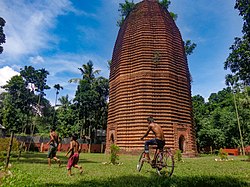 Mathurapur Deul | |
 | |
| Coordinates: 23°32.5′N 89°37.8′E / 23.5417°N 89.6300°E / 23.5417; 89.6300 | |
| Country |  Bangladesh Bangladesh |
| Division | Dhaka |
| District | Faridpur |
| Area | |
| • Total | 230.73 km2 (89.09 sq mi) |
| Population (2011) | |
| • Total | 204,492 |
| • Density | 890/km2 (2,300/sq mi) |
| Time zone | UTC+6 (BST) |
| Website | Official Map of Madhukhali |
Madhukhali (Bengali: মধুখালী) is an upazila of Faridpur District in the Division of Dhaka, Bangladesh. Mathurapur village in Madhukhali has the 16th century ancient Mathurapur Deul and one of the 15 Sugar mills in Bangladesh.[1]
Geography
Madhukhali is located at 23°32′30″N 89°37′50″E / 23.5417°N 89.6306°E / 23.5417; 89.6306. It has 45,939 households and a total area of 230.73 km2.
Demographics
As of the 2011 Bangladesh census, Madhukhali upazila had 45,939 households and a population of 204,492. 45,649 (22.32%) were under 10 years of age. Madhukhali had an average literacy rate of 52.45%, compared to the national average of 51.8%, and a sex ratio of 1010 females per 1000 males. 13,410 (6.57%) of the population lived in urban areas.[2][3]
As of the 1991 Bangladesh census, Madhukhali had a population of 165,438. Males constituted 51.29% of the population, and females 48.71%. The population aged 18 or over was 83,075. Madhukhali has an average literacy rate of 32.5% (7+ years), compared to the national average of 32.4%.[4]
Administration
Madhukhali Upazila is divided into nine union parishads: Bagat, Dumain, Gazna, Jahapur, Kamarkhali, Madhukhali, Megchami, Nowpara, and Raipur. The union parishads are subdivided into 129 mauzas and 242 villages.[5]
See also
References
- ^ Sirajul Ehsan (2012), "Madhukhali Upazila", in Sirajul Islam and Ahmed A. Jamal (ed.), Banglapedia: National Encyclopedia of Bangladesh (Second ed.), Asiatic Society of Bangladesh
- ^ a b "Bangladesh Population and Housing Census 2011 Zila Report – Faridpur" (PDF). bbs.gov.bd. Bangladesh Bureau of Statistics.
- ^ "Community Tables: Faridpur district" (PDF). bbs.gov.bd. Bangladesh Bureau of Statistics. 2011.
- ^ "Population Census Wing, BBS". Archived from the original on 2005-03-27. Retrieved November 10, 2006.
- ^ "District Statistics 2011: Faridpur" (PDF). Bangladesh Bureau of Statistics. Archived from the original (PDF) on 13 November 2014. Retrieved 14 July 2014.
- v
- t
- e


 | This Dhaka Division location article is a stub. You can help Wikipedia by expanding it. |
- v
- t
- e


