Hässleholm Municipality
Municipality in Scania County, Sweden
Hässleholm Municipality Hässleholms kommun | |
|---|---|
Municipality | |
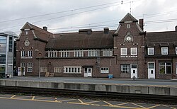 Hässleholm Railway Station | |
 Coat of arms | |
 | |
| Coordinates: 56°10′N 13°46′E / 56.167°N 13.767°E / 56.167; 13.767 | |
| Country | Sweden |
| County | Scania County |
| Seat | Hässleholm |
| Area | |
| • Total | 1,306.27 km2 (504.35 sq mi) |
| • Land | 1,268.53 km2 (489.78 sq mi) |
| • Water | 37.74 km2 (14.57 sq mi) |
| Area as of 1 January 2014. | |
| Population (31 December 2023)[2] | |
| • Total | 52,241 |
| • Density | 40/km2 (100/sq mi) |
| Time zone | UTC+1 (CET) |
| • Summer (DST) | UTC+2 (CEST) |
| ISO 3166 code | SE |
| Province | Scania |
| Municipal code | 1293 |
| Website | www.hassleholm.se |
Hässleholm Municipality (Hässleholms kommun) is a municipality in Scania County in southern Sweden. Its seat is located in the city Hässleholm.
The present municipality was created in 1974 when the former City of Hässleholm, itself incorporated in 1914, was amalgamated with seven surrounding municipalities. In 1863, there were 29 local government units, all rural, in the area.
The municipal coat of arms was granted in 1920 and registered for the new municipality in 1974. The cross symbolizes the railway junction, which is the origin of the town Hässleholm. The hazelnuts allude to the name Hässleholm, which roughly translates as "Hazel-isle".
Geography
At 1,306.27 km2 Hässleholm is the second largest municipality in Skåne County by total area. By land area Hässleholm is the largest in Scania County with 1,268.53 km2 (Kristianstad Municipality short after with 1,246.25 km2), much due to its relatively small water area of 37.74 km2.
Localities
There are 17 urban areas (also called a Tätort or locality) in Hässleholm Municipality.
In the table the localities are listed according to the size of the population as of December 31, 2020. The municipal seat is in bold characters.
| # | Locality | Population |
|---|---|---|
| 1 | Hässleholm | 19,435 |
| 2 | Tyringe | 4,838 |
| 3 | Vinslöv | 4,124 |
| 4 | Bjärnum | 2,805 |
| 5 | Sösdala | 1,873 |
| 6 | Vittsjö | 1,796 |
| 7 | Hästveda | 1,747 |
| 8 | Sjörröd | 1,470 |
| 9 | Tormestorp | 1,051 |
| 10 | Stoby | 747 |
| 11 | Finja | 530 |
| 12 | Vankiva | 387 |
| 13 | Ballingslöv | 361 |
| 14 | Emmaljunga | 313 |
| 15 | Mala | 223 |
| 16 | Hörja | 211 |
| 17 | Västra Torup | 211 |
Demographics
This is a demographic table based on Hässleholm Municipality's electoral districts in the 2022 Swedish general election sourced from SVT's election platform, in turn taken from SCB official statistics.[3]
In total there were 52,201 residents, including 39,480 Swedish citizens of voting age.[3] 37.1% voted for the left coalition and 61.7% for the right coalition.
| Location | Residents | Citizen adults | Left vote | Right vote | Employed | Swedish parents | Foreign heritage | Income SEK | Degree |
|---|---|---|---|---|---|---|---|---|---|
| % | % | ||||||||
| Ballingslöv | 1,219 | 946 | 31.2 | 67.0 | 79 | 87 | 13 | 23,799 | 33 |
| Bjärnum N | 1,738 | 1,255 | 33.1 | 65.6 | 78 | 75 | 25 | 22,900 | 28 |
| Bjärnum S | 1,556 | 1,093 | 33.2 | 65.5 | 72 | 74 | 26 | 20,659 | 28 |
| Bokalyckan | 1,228 | 1,031 | 44.8 | 54.5 | 74 | 74 | 26 | 22,655 | 42 |
| Bokeberg | 1,495 | 1,290 | 45.2 | 53.0 | 72 | 74 | 26 | 18,498 | 35 |
| Djupadal | 1,272 | 1,032 | 37.7 | 61.4 | 78 | 76 | 24 | 23,650 | 40 |
| Finja | 1,498 | 1,136 | 34.9 | 64.5 | 82 | 88 | 12 | 26,130 | 33 |
| Fredentorp | 1,199 | 987 | 40.9 | 58.0 | 78 | 81 | 19 | 21,123 | 29 |
| Gäddastorp | 1,137 | 873 | 36.0 | 63.5 | 84 | 82 | 18 | 28,937 | 52 |
| Haga | 1,484 | 1,061 | 47.3 | 51.7 | 65 | 59 | 41 | 18,131 | 30 |
| Hässleholm C | 1,500 | 1,187 | 40.0 | 58.2 | 72 | 64 | 36 | 20,364 | 36 |
| Hästveda V | 1,357 | 1,028 | 33.0 | 65.2 | 80 | 88 | 12 | 23,825 | 30 |
| Hästveda Ö | 1,531 | 1,074 | 33.2 | 65.5 | 73 | 77 | 23 | 20,860 | 27 |
| Kristinehem-Ekedal | 1,504 | 1,123 | 40.6 | 58.5 | 85 | 71 | 29 | 28,337 | 52 |
| Ljungdala | 1,642 | 1,272 | 48.8 | 50.1 | 84 | 69 | 31 | 26,322 | 42 |
| Läreda | 1,635 | 1,042 | 64.1 | 32.0 | 59 | 26 | 74 | 16,009 | 28 |
| Röke-Hörja | 1,540 | 1,167 | 29.3 | 69.2 | 80 | 89 | 11 | 23,281 | 33 |
| Sjörröd | 1,576 | 1,180 | 30.9 | 68.3 | 87 | 90 | 10 | 31,310 | 52 |
| Stattena | 1,717 | 1,291 | 36.5 | 62.0 | 81 | 73 | 27 | 25,939 | 39 |
| Stoby-Ignaberga | 1,823 | 1,351 | 31.1 | 68.5 | 85 | 86 | 14 | 27,078 | 40 |
| Sösdala V | 1,567 | 1,165 | 40.6 | 58.7 | 77 | 80 | 20 | 21,602 | 32 |
| Sösdala Ö | 1,430 | 1,017 | 36.4 | 62.7 | 73 | 83 | 17 | 21,926 | 32 |
| T4-området | 1,510 | 1,235 | 41.4 | 58.0 | 70 | 68 | 32 | 21,410 | 34 |
| Tormestorp | 1,401 | 1,071 | 33.3 | 65.5 | 85 | 90 | 10 | 28,531 | 43 |
| Tyringe N | 1,615 | 1,178 | 36.4 | 61.4 | 73 | 72 | 28 | 20,889 | 30 |
| Tyringe S | 1,643 | 1,280 | 32.8 | 65.7 | 78 | 86 | 14 | 22,751 | 36 |
| Tyringe V | 1,709 | 1,263 | 39.0 | 59.9 | 71 | 78 | 22 | 19,878 | 27 |
| Vankiva | 1,225 | 966 | 30.5 | 68.4 | 83 | 87 | 13 | 26,150 | 35 |
| Vinslöv C | 1,894 | 1,499 | 36.3 | 63.2 | 82 | 91 | 9 | 23,689 | 32 |
| Vinslöv N | 1,804 | 1,375 | 34.0 | 65.2 | 81 | 91 | 9 | 23,967 | 34 |
| Vinslöv S | 1,865 | 1,380 | 31.0 | 68.3 | 87 | 90 | 10 | 26,480 | 32 |
| Vittsjö C | 1,783 | 1,321 | 35.8 | 62.8 | 72 | 78 | 22 | 21,014 | 34 |
| Vittsjö | 1,300 | 983 | 27.4 | 71.2 | 76 | 85 | 15 | 21,579 | 33 |
| Östervärn-Röinge | 1,804 | 1,328 | 42.6 | 56.9 | 84 | 76 | 24 | 27,566 | 46 |
| Source: SVT[3] | |||||||||
Industry
- Hässleholms Workshops
- Göinge Mechanical Workshop
- Hässleholms Brewery
- Hässleholms Kapsyl- och Stanniolfabrik
- Hässleholms Filfabrik
Sport in Hässleholm
Twin towns


Notable residents
- Bengt Bauler
- Johan T Karlsson
- Ida-Theres Nerell
- Pia Hansen
- Andreas Tilliander
- Grönwalls
- Andreas Dahl, football (soccer) player
- Jon Jönsson, football (soccer) player
- Ingrid Swede, film
- Jan Brink
- Åke "Kometen" Persson
- Jeanette Thelander
- Anders S. Nilsson
- Glenn Wish
- Neneh Cherry, Swedish-American singer born here but raised in London and New York City
- Martin Ingvarsson
- Joddla med Siv
- Freddie Ljungberg, footballer born in Vittsjö, but grew up in Halmstad
- Nilla Fischer, footballer
- Gustav Fridolin, Sweden's youngest parliament member, now a journalist for Kalla Fakta
- Bildsköne Bengtsson
- Peps Persson, musician
- KG Hammar, former archbishop
- Gunhild Sehlin
References
- Statistics Sweden
- ^ "Statistiska centralbyrån, Kommunarealer den 1 januari 2014" (in Swedish). Statistics Sweden. 2014-01-01. Archived from the original (Microsoft Excel) on 2016-09-27. Retrieved 2014-04-18.
- ^ "Folkmängd och befolkningsförändringar - Kvartal 4, 2023" (in Swedish). Statistics Sweden. February 22, 2024. Retrieved February 22, 2024.
- ^ a b c "Valresultat 2022 för Hässleholm i riksdagsvalet" (in Swedish). SVT. 11 September 2022. Retrieved 1 February 2024.
External links
Wikimedia Commons has media related to Hässleholm Municipality.
- Hässleholm Municipality - Official site
Places adjacent to Hässleholm Municipality | ||||||||||||||||
|---|---|---|---|---|---|---|---|---|---|---|---|---|---|---|---|---|
| ||||||||||||||||


Authority control databases | |
|---|---|
| International |
|
| National |
|
| Geographic |
|


