Eerste River

River in the Western Cape, South Africa
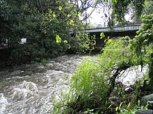
Eerste River in Stellenbosch after heavy rains
The rivers of the Cape region with the Eerste River (left center)

The Eerste River, located in the Western Cape, South Africa, rises on Dwarsberg 60 km east of Cape Town at the head of Jonkershoek valley. The Eerste River catchment covers the eastern part of the Cape Flats lying to the west of the Hottentots Holland Mountains and south of the Tygerberg where the Kuils River tributary rises east of Kanonkop. The Eerste River is a short river; its length has been given as 40 km. The major tributary, Kuils River, is approximately 30 km long to its point of confluence with the Eerste River.[1]

For a significant part of its course, the river flows through the City of Cape Town.[1]

A population of the endangered local endemic Berg River Redfin (Pseudobarbus burgi) was found in the Eerste River. It has become extinct in recent times.

Tributaries

From "Rivers and Wetlands of Cape Town", ordered from source to sea:[1]

  • Jonkershoek River
  • Plankenbrug River (R)
    • Klipies River (L)
    • Kromme River (L)
  • Veldwachters River (R)
  • Sanddrif River (R)
  • Blouklip River (L)
  • Bonte River (L)
  • Kuils River (R)
    • Bottelary River (L)
    • Kleinvlei canal (L)
  • Moddergat canal (L)

Bridges

  • N2 Highway bridge.[1]
  • At the Kramat of Sheik Yusuf in Macassar.[1]

Estuary and mouth

The river mouth is at 34°04.873′S 18°45.887′E / 34.081217°S 18.764783°E / -34.081217; 18.764783, in Macassar, on the north shore of False Bay.

The estuary is at the eastern end of a large calcrete dune, and is part of the boundary of the Helderberg Marine Protected Area. In its natural state the estuary was a small temporarily open system with little tidal flow. The state of the mouth was controlled by river flow, and under natural conditions, seawater intrusion would maintain an estuarine ecology. When the mouth closed, the river would back up past the Kramat to Zandvliet farm.[1]

See also

References

  1. ^ a b c d e f Murray, Tony; Brown, Cate; Dollar, Evan; Day, Jenny; Beuster, Hans; Haskins, Candice; Boucher, Charlie; Turpie, Jane; Wood, Julia; Thompson, Martin; Lamberth, Steve; van Niekerk, Lara; Impson, Dean; Magoba, Rembu; Petersen, Chantel; Davey, Denis; Noffke, Mandy; Hay, Rowena; Hartnady, Chris; Ewart-Smith, Justine; Burger, Marius; Fairburn, Emily; Ractliffe, Geordie; Day, Liz; Luger, Mike; Lannas, Katy; Ndiitwani-Nyamande, Tovhowani (2009). Brown, Cate; Magoba, Rembu (eds.). Rivers and Wetlands of Cape Town (Part 2) (PDF). Project No: K5/1691 (Report). Water Research Commission. pp. 179–380.
  • List of South African Dams from the Department of Water Affairs and Forestry (South Africa)

34°05′S 18°46′E / 34.083°S 18.767°E / -34.083; 18.767

  • v
  • t
  • e
Natural environment
Bays
Beaches
Hills
Mountains
Islands
Headlands
Rivers and wetlands
Climate and weather
World heritage sites
Biodiversity
of Cape Town
Vegetation
types
Parks and
gardens
Nature reserves
Communities
Atlantic Seaboard
Blaauwberg
Cape Flats
(Klipfontein district)
Khayelitsha
Mitchells Plain
City Bowl
Helderberg
Northern Suburbs
Southern Suburbs
South Peninsula
Neighbourhoods
Built environment
Skyscrapers
Government
National government
Provincial government
City of Cape Town
Fortifications
Monuments and memorials
Lists of heritage sites
Historical buildings
Culture
Cuisine
Performance
art
Events and
festivals
Museums and
art galleries
Iziko Museums
Public art
Religion
Secular
architecture
Media
Companies based
in Cape Town
Hotels and resorts
Shopping areas,
malls and markets
Exhibition centres
Restaurants and cafés
Tourism
Air transport
Maritime transport
Road transport
Rail transport
Soccer
Rugby
Cricket
Other
Cape Town Tigers (basketball)
Sports events
Sports venues
Libraries
Universities
Colleges
Private
schools
Public schools
Alternative schools
Former schools
Art & Music schools
Not yet allocated
Services
Hospitals
Lighthouses
Western Cape
Water Supply System
Electrical power generation
Emergency services
Cape Town Outline