Zajasovnik
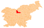
Place in Slovenia
46°12′31″N 14°54′8.23″E / 46.20861°N 14.9022861°E / 46.20861; 14.9022861 Slovenia
 (2002)
Zajasovnik (pronounced [zaˈjaːsɔu̯nik]) is a dispersed settlement that is divided between the municipalities of Kamnik and Vransko in Slovenia.
Cultural heritage

An Austro-Hungarian boundary stone marking the border between Carniola and Styria stands at the border between the two parts of Zajasovnik.[2]
References
External links
 Media related to Zajasovnik at Wikimedia Commons
- Zajasovnik (Kamnik) on Geopedia
- Zajasovnik (Vransko) on Geopedia
- v
- t
- e
Municipality of Kamnik
Administrative seat: Kamnik
- Big Pasture Plateau
- Kamnik Bistrica Valley
- Kamnik Parish Church
- Little Castle
- Menina Pasture Plateau
- Nevljica
- Snovik Spa
- St. Primus' Church
- Tuhinj Valley
- Tunjice Natural Health Resort
- Volčji Potok Arboretum
- Zaprice Castle
| ||
|---|---|---|
| Settlements |  | |
| Landmarks | ||


