West Nanticoke, Pennsylvania
Census-designated place in Pennsylvania, United States
41°13′18″N 76°0′54″W / 41.22167°N 76.01500°W / 41.22167; -76.01500 (2010)
West Nanticoke is a census-designated place (CDP) in Plymouth Township, Luzerne County, Pennsylvania, United States, across the Susquehanna River from the city of Nanticoke. The population of the CDP was 749 at the 2010 census.[1]
Geography
West Nanticoke is located at 41°13′18″N 76°0′54″W / 41.22167°N 76.01500°W / 41.22167; -76.01500,[2] along U.S. Route 11, on the north bank of the Susquehanna River. It is across the river from the city of Nanticoke, to which it is connected by the Lower Broadway Street Bridge. Pennsylvania Route 29 joins U.S. Route 11 in the center of West Nanticoke. To the north, Route 29 leads to Silkworth and Pikes Creek. Just east of West Nanticoke, Route 29 becomes the South Cross Valley Expressway, crossing the Susquehanna River and leading to Interstate 81 south of Wilkes-Barre. U.S. Route 11 heads northeast to Plymouth and Kingston and southwest to Shickshinny and Berwick.
According to the United States Census Bureau, West Nanticoke has a total area of 0.69 square miles (1.8 km2), of which 0.58 square miles (1.5 km2) is land and 0.12 square miles (0.3 km2), or 17.2%, is water.[3]
Gallery
-
 Tilsburys Knob, West Nanticoke
 -
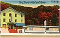 A hotel and diner along U.S. 11 in West Nanticoke
 -
 Harveys Creek looking upstream in West Nanticoke
 -
 Harveys Creek looking downstream in West Nanticoke


References
- ^ "Profile of General Population and Housing Characteristics: 2010 Demographic Profile Data (DP-1): West Nanticoke CDP, Pennsylvania". United States Census Bureau. Retrieved April 30, 2012.
- ^ "US Gazetteer files: 2010, 2000, and 1990". United States Census Bureau. February 12, 2011. Retrieved April 23, 2011.
- ^ "Geographic Identifiers: 2010 Demographic Profile Data (G001): West Nanticoke CDP, Pennsylvania". United States Census Bureau. Retrieved April 30, 2012.
- v
- t
- e
Municipalities and communities of Luzerne County, Pennsylvania, United States
County seat: Wilkes-Barre

- Ashley
- Avoca
- Bear Creek Village
- Conyngham
- Courtdale
- Dallas
- Dupont
- Duryea
- Edwardsville
- Exeter
- Forty Fort
- Freeland
- Harveys Lake
- Hughestown
- Jeddo
- Kingston
- Laflin
- Larksville
- Laurel Run
- Luzerne
- Nescopeck
- New Columbus
- Nuangola
- Penn Lake Park
- Plymouth
- Pringle
- Shickshinny
- Sugar Notch
- Swoyersville
- Warrior Run
- West Hazleton
- West Pittston
- West Wyoming
- White Haven
- Wyoming
- Yatesville
- Beech Mountain Lakes
- Browntown
- Chase
- East Berwick
- Georgetown
- Glen Lyon
- Harleigh
- Hickory Hills
- Hilldale
- Hudson
- Inkerman
- Lattimer
- Misericordia University
- Mocanaqua
- Mountain Top
- Nuremberg‡
- Pardeesville
- Pikes Creek
- Plains
- Shavertown
- Sheatown
- Silkworth
- Trucksville
- Upper Exeter
- Wanamie
- West Nanticoke
- Weston
communities
- Alden
- Back Mountain
- Beach Haven
- Breslau
- Cambra
- Cranberry
- Drifton
- Drums
- Ebervale
- Glen Summit Springs
- Harveyville
- Humboldt
- Hunlock Creek
- Huntington Mills
- Japan
- Koonsville
- Korn Krest
- Kunkle
- Lehman
- Milnesville
- Moosehead
- Mossville
- Mountain Grove
- Old Boston
- Port Griffith
- Rock Glen
- Saint Johns
- Sandy Run
- Suscon
- Sweet Valley
- Sybertsville
- Tomhicken
- Wapwallopen
- Waterton
- Zenith
‡This populated place also has portions in an adjacent county or counties
- Pennsylvania portal
- United States portal


