Weißenkirchen in der Wachau
Place in Lower Austria, Austria

Coat of arms
(2018-01-01)[2]
3610
Weißenkirchen in der Wachau is a town in the district of Krems-Land in the Austrian state of Lower Austria. The ferry across the Danube here is interesting in that it has no motor or sail: it is powered by rudder set against the river current, anchored to a cable above the river. The ferry carries passengers, bicycles, motorcycles, and automobiles.
Population
| Year | Pop. | ±% |
|---|---|---|
| 1971 | 1,672 | — |
| 1981 | 1,601 | −4.2% |
| 1991 | 1,563 | −2.4% |
| 2001 | 1,494 | −4.4% |
-
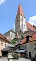 View from the market square to the parish church
 -
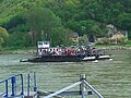 Ferry between Weißenkirchen and St. Lorenz before mooring at Weißenkirchen
 -
 Parish church of Weißenkirchen


References
Wikivoyage has a travel guide for Weißenkirchen in der Wachau.
- v
- t
- e
Municipalities in the district of Krems (Land)
- Aggsbach
- Albrechtsberg an der Großen Krems
- Bergern im Dunkelsteinerwald
- Droß
- Dürnstein
- Furth bei Göttweig
- Gedersdorf
- Gföhl
- Grafenegg
- Hadersdorf-Kammern
- Jaidhof
- Krumau am Kamp
- Langenlois
- Lengenfeld
- Lichtenau im Waldviertel
- Maria Laach am Jauerling
- Mautern an der Donau
- Mühldorf
- Paudorf
- Rastenfeld
- Rohrendorf bei Krems
- Rossatz-Arnsdorf
- Schönberg am Kamp
- Senftenberg
- Spitz
- St. Leonhard am Hornerwald
- Straß im Straßertale
- Stratzing
- Weinzierl am Walde
- Weißenkirchen in der Wachau

Authority control databases | |
|---|---|
| International |
|
| National |
|
 | This Lower Austria location article is a stub. You can help Wikipedia by expanding it. |
- v
- t
- e


