Vallo della Lucania
You can help expand this article with text translated from the corresponding article in Italian. (January 2022) Click [show] for important translation instructions.
- Machine translation, like DeepL or Google Translate, is a useful starting point for translations, but translators must revise errors as necessary and confirm that the translation is accurate, rather than simply copy-pasting machine-translated text into the English Wikipedia.
- Do not translate text that appears unreliable or low-quality. If possible, verify the text with references provided in the foreign-language article.
- You must provide copyright attribution in the edit summary accompanying your translation by providing an interlanguage link to the source of your translation. A model attribution edit summary is
Content in this edit is translated from the existing Italian Wikipedia article at [[:it:Vallo della Lucania]]; see its history for attribution. - You may also add the template
{{Translated|it|Vallo della Lucania}}to the talk page. - For more guidance, see Wikipedia:Translation.
Comune in Campania, Italy

Coat of arms

Vallo within the Province of Salerno
Location of Vallo della Lucania

40°14′N 15°16′E / 40.233°N 15.267°E / 40.233; 15.267
(31 December 2011)[2]
84078, 84040, 84050, 84060
Vallo della Lucania (commonly known simply as Vallo) is a town and comune in the province of Salerno in the Campania region of south-western Italy. It lies in the middle of Cilento and its population is 8,680.[2]
History
A settlement called Castrum Cornutum (meaning: "Fortress of Cornutans") is documented in the 13th century: according to the Italian historian Giuseppe Maiese, it had been founded by colonists from Cornutum, an ancient city in Dalmatia. In the 18th century the town changed its name to Vallo di Novi. In 1806, during the French government of the Kingdom of Naples, it was made a district capital.
Geography
The town is located in the middle of the Cilento and its National Park, close to Gelbison mountain.
The municipality borders with Cannalonga, Castelnuovo Cilento, Ceraso, Gioi, Moio della Civitella, Novi Velia, and Salento.[3] The hamlets (frazioni) are Angellara, Massa, and Pattano.
Gallery
-
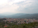 Town's view
 -
 San Pantaleone church


See also
- Cilento
- Gelbison (mountain)
- Gelbison Cilento (football club)
- Roman Catholic Diocese of Vallo della Lucania
References
- ^ "Superficie di Comuni Province e Regioni italiane al 9 ottobre 2011". Italian National Institute of Statistics. Retrieved 16 March 2019.
- ^ a b (in Italian) Source: Istat 2011
- ^ 40352
(x a j h)Vallo della Lucania on OpenStreetMap
External links
Wikimedia Commons has media related to Vallo della Lucania.
- (in Italian) Comune of Vallo della Lucania
- Photos of the town
- v
- t
- e
- Acerno
- Agropoli
- Albanella
- Alfano
- Altavilla Silentina
- Amalfi
- Angri
- Aquara
- Ascea
- Atena Lucana
- Atrani
- Auletta
- Baronissi
- Battipaglia
- Bellizzi
- Bellosguardo
- Bracigliano
- Buccino
- Buonabitacolo
- Caggiano
- Calvanico
- Camerota
- Campagna
- Campora
- Cannalonga
- Capaccio
- Casal Velino
- Casalbuono
- Casaletto Spartano
- Caselle in Pittari
- Castel San Giorgio
- Castel San Lorenzo
- Castelcivita
- Castellabate
- Castelnuovo Cilento
- Castelnuovo di Conza
- Castiglione del Genovesi
- Cava de' Tirreni
- Celle di Bulgheria
- Centola
- Ceraso
- Cetara
- Cicerale
- Colliano
- Conca dei Marini
- Controne
- Contursi Terme
- Corbara
- Corleto Monforte
- Cuccaro Vetere
- Eboli
- Felitto
- Fisciano
- Furore
- Futani
- Giffoni Sei Casali
- Giffoni Valle Piana
- Gioi
- Giungano
- Ispani
- Laureana Cilento
- Laurino
- Laurito
- Laviano
- Lustra
- Magliano Vetere
- Maiori
- Mercato San Severino
- Minori
- Moio della Civitella
- Montano Antilia
- Monte San Giacomo
- Montecorice
- Montecorvino Pugliano
- Montecorvino Rovella
- Monteforte Cilento
- Montesano sulla Marcellana
- Morigerati
- Nocera Inferiore
- Nocera Superiore
- Novi Velia
- Ogliastro Cilento
- Olevano sul Tusciano
- Oliveto Citra
- Omignano
- Orria
- Ottati
- Padula
- Pagani
- Palomonte
- Pellezzano
- Perdifumo
- Perito
- Pertosa
- Petina
- Piaggine
- Pisciotta
- Polla
- Pollica
- Pontecagnano Faiano
- Positano
- Postiglione
- Praiano
- Prignano Cilento
- Ravello
- Ricigliano
- Roccadaspide
- Roccagloriosa
- Roccapiemonte
- Rofrano
- Romagnano al Monte
- Roscigno
- Rutino
- Sacco
- Sala Consilina
- Salento
- Salerno
- Salvitelle
- San Cipriano Picentino
- San Giovanni a Piro
- San Gregorio Magno
- San Mango Piemonte
- San Marzano sul Sarno
- San Mauro Cilento
- San Mauro la Bruca
- San Pietro al Tanagro
- San Rufo
- San Valentino Torio
- Sant'Angelo a Fasanella
- Sant'Arsenio
- Sant'Egidio del Monte Albino
- Santa Marina
- Santomenna
- Sanza
- Sapri
- Sarno
- Sassano
- Scafati
- Scala
- Serramezzana
- Serre
- Sessa Cilento
- Siano
- Sicignano degli Alburni
- Stella Cilento
- Stio
- Teggiano
- Torchiara
- Torraca
- Torre Orsaia
- Tortorella
- Tramonti
- Trentinara
- Valle dell'Angelo
- Vallo della Lucania
- Valva
- Vibonati
- Vietri sul Mare
Authority control databases | |
|---|---|
| International |
|
| National |
|
| Geographic |
|
 | This Campanian location article is a stub. You can help Wikipedia by expanding it. |
- v
- t
- e


