Uddel
Village in Gelderland, Netherlands
52°15′27″N 5°46′57″E / 52.25750°N 5.78250°E / 52.25750; 5.78250 (1 January 2015)[1]
3888
Uddel is a village in the Netherlands, on the Veluwe, in the municipality of Apeldoorn, Gelderland, Netherlands. Uddel is located on the N310 from Elburg to Arnhem. The oldest mention of Uddel dates back to the year 792, as the settlement Uttiloch. The village had 2,927 inhabitants in 2016.
Uddel is a conservative Protestant village, located on the Dutch Bible Belt. In the 2017 general election, 57 percent of the local population voted for the Reformed Political Party. The three Christian parties in the elections (the Reformed Political Party, the ChristianUnion and the Christian Democratic Appeal) had a combined total of almost 76 percent of the votes.[3]
Uddel is well known for its lake, the Uddelermeer [nl], with its unique geological formation. The lake is mentioned in the folk tale documented by van de Wall Perne in his book Veluwsche Sagen.[4]
Notable inhabitants
- Gerrit Holdijk (1944-2015), jurist and politician (SGP)
Gallery
-
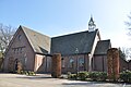 Reformed Congregation in the Netherlands De Beek-Uddel
 -
 Uddelermeer
 -
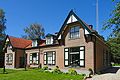
 House in Uddel
 -
 Game warden residence of the Crown domain


References
- ^ a b "Apeldoorn in Cijfers" (in Dutch). Retrieved 20 October 2015.
- ^ "Actueel Hoogtebestand Nederland: Viewer" (in Dutch). Retrieved 20 October 2015.
- ^ "Uitslagenkaart Tweede Kamerverkiezingen 2017 per stambureau".
- ^ van de Wall Perné, Gustaaf Frederik (1993). Veluwsche sagen (1e dr ed.). Den Haag: Sirius en Siderius. ISBN 9064411034. OCLC 66374844.
External links
 Media related to Uddel at Wikimedia Commons
Authority control databases | |
|---|---|
| International |
|
| National |
|
 | This Gelderland location article is a stub. You can help Wikipedia by expanding it. |
- v
- t
- e


