Tsento Gewog
Gewogs in Paro District, Bhutan
Tsento Gewog བཙན་ཏོ་ | |
|---|---|
Gewogs | |
 | |
| Country |  Bhutan Bhutan |
| District | Paro District |
| Time zone | UTC+6 (BTT) |
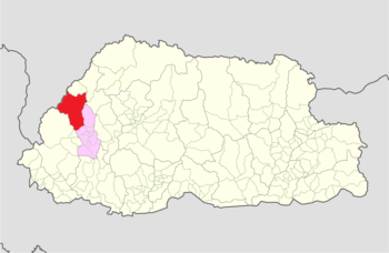
Tsento Gewog (Dzongkha: བཙན་ཏོ་) is a gewog (village block) of Paro District, Bhutan.[1] In 2002, the gewog had an area of 575.1 square kilometres and contained 14 villages and 332 households.[2] The border can be accessed through a secret road/trail connecting Phari in China (27°41′56″N 89°11′21″E / 27.698912°N 89.189139°E / 27.698912; 89.189139) known as Tremo La.
Schools
References
- v
- t
- e
Village groups (gewogs) of Bhutan
Bhutan Zone
| Dagana District | |
|---|---|
| Gasa District | |
| Punakha District | |
| Tsirang District | |
| Wangdue Phodrang District |

Bhutan Zone
| Bumthang District | |
|---|---|
| Sarpang District | |
| Trongsa District | |
| Zhemgang District |
Bhutan Zone
| Chukha District | |
|---|---|
| Haa District | |
| Paro District | |
| Samtse District | |
| Thimphu District |
Bhutan Zone
| Lhuntse District | |
|---|---|
| Mongar District | |
| Pemagatshel District | |
| Samdrup Jongkhar District | |
| Trashigang District | |
| Trashiyangtse District |
| Dagana District | |
|---|---|
| Chukha District | |
| Pemagatshel District | |
| Samtse District | |
| Sarpang District | |
| Thimphu District | |
| Tsirang District | |
| Samdrup Jongkhar District |
 | This Bhutan location article is a stub. You can help Wikipedia by expanding it. |
- v
- t
- e


