Tolna District
Districts of Hungary in Tolna
Tolna District Tolnai járás | |
|---|---|
Districts of Hungary | |
 Coat of arms | |
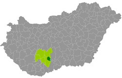 Tolna District within Hungary and Tolna County. | |
| Country |  Hungary Hungary |
| County | Tolna |
| District seat | Tolna (town) |
| Area | |
| • Total | 205.24 km2 (79.24 sq mi) |
| • Rank | 6th in Tolna |
| Population (2011 census) | |
| • Total | 18,203 |
| • Rank | 6th in Tolna |
| • Density | 89/km2 (230/sq mi) |
Tolna (Hungarian: Tolnai járás) is a district in eastern part of Tolna County. Tolna is also the name of the town where the district seat is found. The district is located in the Southern Transdanubia Statistical Region.
Geography
Tolna District borders with Paks District to the north, Kalocsa District (Bács-Kiskun County) to the east, Szekszárd District to the south and west. The number of the inhabited places in Tolna District is 4.
Municipalities
The district has 1 town, 1 large village and 2 villages. (ordered by population, as of 1 January 2013)[1]
The bolded municipality is city, italics municipality is large village.
See also
References
- ^ "A KSH 2013. évi helységnévkönyve". ksh.hu. Retrieved 2017-12-26.
External links
- Postal codes of the Tolna District

46°25′21″N 18°46′07″E / 46.42260779260526°N 18.7685640909405°E / 46.42260779260526; 18.7685640909405
 | This Tolna location article is a stub. You can help Wikipedia by expanding it. |
- v
- t
- e


