Staré
Municipality of Slovakia
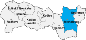
Staré (Hungarian: Sztára) is a village and municipality in Michalovce District in the Kosice Region of eastern Slovakia.
History
In historical records the village was first mentioned in 1221.
Geography
The village lies at an altitude of 107 metres and covers an area of 6.234 km2. The municipality has a population of about 700 people. The name was taken from gróf Sztáray. [1]
See also
Gallery
-
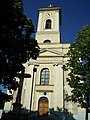 Church of the Assumption of the Virgin Mary, est. 1842 (July 2006)
 -
 Statue of John of Nepomuk in Staré
 -
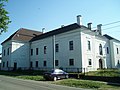 Manor house in Staré, est. early 1600s (July 2006)
 -
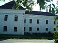 Manor house in Staré, est. early 1600s (July 2006)
 -
 Manor house in Staré, est. early 1600s (July 2006)
 -
 Village granary in Neo-Classical style, est. 1804 (July 2006)
 -
 Village granary in Neo-Classical style, est. 1804 (July 2006)
 -
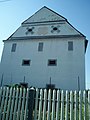 Village granary in Neo-Classical style, est. 1804 (July 2006)


References
- ^ "Obec Staré". Archived from the original on 2010-02-14.
External links
Wikimedia Commons has media related to Staré.
- http://www.statistics.sk/mosmis/eng/run.html
- http://www.stare.sk
- http://www.obecstare.wz.cz
- https://web.archive.org/web/20080110184734/http://www.farnost-stare.sk/
- v
- t
- e
Municipalities of Michalovce District
- Michalovce
- Strážske
- Veľké Kapušany
- Bajany
- Bánovce nad Ondavou
- Beša
- Bracovce
- Budince
- Budkovce
- Čečehov
- Čičarovce
- Čierne Pole
- Drahňov
- Dúbravka
- Falkušovce
- Hatalov
- Hažín
- Hnojné
- Horovce
- Iňačovce
- Ižkovce
- Jastrabie pri Michalovciach
- Jovsa
- Kačanov
- Kaluža
- Kapušianske Kľačany
- Klokočov
- Krásnovce
- Krišovská Liesková
- Kusín
- Lastomír
- Laškovce
- Lesné
- Ložín
- Lúčky
- Malčice
- Malé Raškovce
- Markovce
- Maťovské Vojkovce
- Moravany
- Nacina Ves
- Oborín
- Oreské
- Palín
- Pavlovce nad Uhom
- Petrikovce
- Petrovce nad Laborcom
- Poruba pod Vihorlatom
- Pozdišovce
- Ptrukša
- Pusté Čemerné
- Rakovec nad Ondavou
- Ruská
- Senné
- Slavkovce
- Sliepkovce
- Staré
- Stretava
- Stretavka
- Suché
- Šamudovce
- Trhovište
- Trnava pri Laborci
- Tušice
- Tušická Nová Ves
- Veľké Raškovce
- Veľké Slemence
- Vinné
- Vojany
- Voľa
- Vrbnica
- Vysoká nad Uhom
- Zalužice
- Závadka
- Zbudza
- Zemplínska Široká
- Zemplínske Kopčany
- Žbince

48°52′N 21°52′E / 48.867°N 21.867°E / 48.867; 21.867
 | This Michalovce District geography article is a stub. You can help Wikipedia by expanding it. |
- v
- t
- e


