Solna strand metro station
Stockholm Metro station
59°21′15″N 17°58′26″E / 59.35417°N 17.97389°E / 59.35417; 17.97389| Preceding station |  Stockholm metro Stockholm metro | Following station | ||
|---|---|---|---|---|
| Huvudsta towards Kungsträdgården | Line 10 | Sundbybergs centrum towards Hjulsta | ||
Location | |
|---|---|
 |
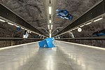
Solna strand (known as Vreten until 18 August 2014[2]) is a subway station on the Stockholm metro blue line. It was opened on 18 August 1985 as part of the extension between Västra skogen and Rinkeby[3] and is located in the Huvudsta region of the Solna Municipality. The platform is located in bedrock, 28 m (92 ft) below ground level under Vretenvägen. The entrance is in the north end at Korta gatan. The station's theme is defined by artwork created by the Japanese-Swedish sculptor Takashi Naraha in 1985 called Himmelen av kub (The heaven of cube).

It is located in and named after Solna Strand, a former industrial area on the shore of Lake Mälaren that has since developed into an area of office buildings. Organisations here include the Swedish Tax Authority, Hewlett-Packard and Axfood.[4][5] There is also a power plant by the coast. Until 2014 the area was called Vretens industriområde (Vreten industrial area), after the farmstead called Vreten which was located here in the 19th century.[6] Solna Business Park is located across the Mälaren Line railway to the north, and the Sundbyberg Municipality districts Lilla Alby and Central Sundbyberg are located to the west.
Gallery
-
 Entrance
 -
 Artwork on the platform


References
- ^ "Fakta om SL och regionen 2019" (PDF) (in Swedish). Storstockholms Lokaltrafik. p. 51. Archived (PDF) from the original on 27 December 2020. Retrieved 1 April 2021.
- ^ Wiik, Christer (18 August 2014). "Solna strand ersätter Vreten". Järnvägsnyheter.se (in Swedish). Conventus Media House AB. Retrieved 22 January 2017.
- ^ Schwandl, Robert. "Stockholm". urbanrail.
- ^ "Vretens t-banestation byter namn". Sveriges Television. 12 Nov 2013. Retrieved 21 Mar 2021.
- ^ "Komplexität am Arbeitsplatz - Bürobau in Stockholm von Tham & Videgård". BauNetz. 18 Mar 2021. Retrieved 22 Mar 2021.
- ^ "Till minne av Vreten, 1985-2014". Dagens Nyheter. 2014-08-18. Retrieved 21 Mar 2021.
External links
![]() Media related to Solna strand Metro station at Wikimedia Commons
Media related to Solna strand Metro station at Wikimedia Commons
- v
- t
- e

| 10 | |||||
|---|---|---|---|---|---|
| 11 | |||||
| Abandoned stations | |||||
| Future stations |
|


 | This article about a Swedish railway station is a stub. You can help Wikipedia by expanding it. |
- v
- t
- e
 | This Stockholm Metro article is a stub. You can help Wikipedia by expanding it. |
- v
- t
- e


