Shah Alborz
Mountain in Iran


Shah Alborz
شاه البرز
شاه البرز
Border of Tehran and Qazvīn Province, Iran
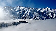
Shah Alborz (Persian: شاه البرز) is a mountain peak in Alborz range in Iran. At an elevation of 4,200 metres (13,800 ft),[1] it is the highest peak in the range. Its north face rises from the Alamout valley. To the south lies the Taleghan Valley and to the west the plains of east-Ghazvin. The Shah Alborz glaciercovers parts of the north face at elevations of 3,400 to 3,600 metres (11,200 to 11,800 ft).[2]
| Map of central Alborz | Peaks: | 1 Alam-Kuh |
|---|---|---|
 −25 to 500 m (−82 to 1,640 ft) 500 to 1,500 m (1,600 to 4,900 ft) 1,500 to 2,500 m (4,900 to 8,200 ft) 2,500 to 3,500 m (8,200 to 11,500 ft) 3,500 to 4,500 m (11,500 to 14,800 ft) 4,500 to 5,610 m (14,760 to 18,410 ft) | 2 Azad Kuh | 3 Damavand |
| 4 Do Berar | 5 Do Khaharan | |
| 6 Ghal'eh Gardan | 7 Gorg | |
| 8 Kholeno | 9 Mehr Chal | |
| 10 Mishineh Marg | 11 Naz | |
| 12 Shah Alborz | 13 Sialan | |
| 14 Tochal | 15 Varavašt | |
| Rivers: | 0 | |
| 1 Alamut | 2 Chalus | |
| 3 Do Hezar | 4 Haraz | |
| 5 Jajrood | 6 Karaj | |
| 7 Kojoor | 8 Lar | |
| 9 Noor | 10 Sardab | |
| 11 Seh Hazar | 12 Shahrood | |
| Cities: | 1 Amol | |
| 2 Chalus | 3 Karaj | |
| Other: | D Dizin | |
| E Emamzadeh Hashem | K Kandovan Tunnel | |
| * Latyan Dam | ** Lar Dam |
Climbing
The level of difficulty is "walk-up" and the nearest center is Taleghan. The best months to climb the mountain are from March to September.[1] The most often-used route to the peak passes through the Hasanjoon valley.[3]


