Santa Eugènia
Municipality in Balearic Islands, Spain
Flag

Coat of arms
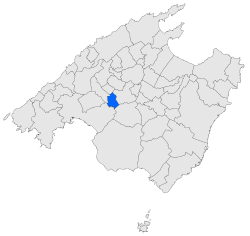
Map of Santa Eugènia in Mallorca
39°37′25″N 2°50′21″E / 39.62361°N 2.83917°E / 39.62361; 2.83917
(2018)[1]
07142
Santa Eugènia (Catalan pronunciation: [səntəwˈʒɛ.ni(ə)]) is a small municipality in the comarca of Pla de Mallorca on Majorca, one of the Balearic Islands, Spain.
Named after Saint Eugenia of Rome.
History
In prehistoric times, the area was settled by the Talaiotic Culture.
After the Moorish conquest of Iberia, it was ruled by the Berber Zenata people, until it was captured by King James I of Aragon in 1229.
References
- ^ Municipal Register of Spain 2018. National Statistics Institute.
- v
- t
- e
Municipalities in the Balearic Islands
- Alaró
- Alcúdia
- Algaida
- Andratx
- Ariany
- Artà
- Banyalbufar
- Binissalem
- Búger
- Bunyola
- Calvià
- Campanet
- Campos
- Capdepera
- Consell
- Costitx
- Deià
- Escorca
- Esporles
- Estellencs
- Felanitx
- Fornalutx
- Inca
- Lloret de Vistalegre
- Lloseta
- Llubí
- Llucmajor
- Manacor
- Mancor de la Vall
- Maria de la Salut
- Marratxí
- Montuïri
- Muro
- Palma
- Petra
- Sa Pobla
- Pollença
- Porreres
- Puigpunyent
- Ses Salines
- Sant Joan
- Sant Llorenç des Cardassar
- Santa Eugènia
- Santa Margalida
- Santa Maria del Camí
- Santanyí
- Selva
- Sencelles
- Sineu
- Sóller
- Son Servera
- Valldemossa
- Vilafranca de Bonany

- Ibiza
- Sant Antoni de Portmany
- Sant Joan de Labritja
- Sant Josep de sa Talaia
- Santa Eulària des Riu
| Authority control databases |
|
|---|
 | This article about a location in the Balearic Islands is a stub. You can help Wikipedia by expanding it. |
- v
- t
- e


