Sankt Gotthard im Mühlkreis
You can help expand this article with text translated from the corresponding article in German. (November 2016) Click [show] for important translation instructions.
- View a machine-translated version of the German article.
- Machine translation, like DeepL or Google Translate, is a useful starting point for translations, but translators must revise errors as necessary and confirm that the translation is accurate, rather than simply copy-pasting machine-translated text into the English Wikipedia.
- Consider adding a topic to this template: there are already 9,156 articles in the main category, and specifying
|topic=will aid in categorization. - Do not translate text that appears unreliable or low-quality. If possible, verify the text with references provided in the foreign-language article.
- You must provide copyright attribution in the edit summary accompanying your translation by providing an interlanguage link to the source of your translation. A model attribution edit summary is
Content in this edit is translated from the existing German Wikipedia article at [[:de:St. Gotthard im Mühlkreis]]; see its history for attribution. - You may also add the template
{{Translated|de|St. Gotthard im Mühlkreis}}to the talk page. - For more guidance, see Wikipedia:Translation.
Place in Upper Austria, Austria

Coat of arms
(2018-01-01)[2]
4112
Sankt Gotthard im Mühlkreis is a municipality in the district of Urfahr-Umgebung in Upper Austria, Austria.
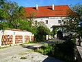
Attractions include Schloss Eschelberg, a stately home built in 1596, and the ruined 13th-century Rottenegg Castle.[3]
Villages
The municipality contains the following villages:
- Eschelberg
- Grasbach
- Haselwies
- Maierleiten
- Mühlholz
- Oberstraß
- Rottenegg
Population
| Year | Pop. | ±% |
|---|---|---|
| 1869 | 779 | — |
| 1890 | 790 | +1.4% |
| 1910 | 756 | −4.3% |
| 1923 | 761 | +0.7% |
| 1934 | 742 | −2.5% |
| 1939 | 688 | −7.3% |
| 1951 | 966 | +40.4% |
| 1971 | 975 | +0.9% |
| 1991 | 1,125 | +15.4% |
| 2001 | 1,299 | +15.5% |
| 2007 | 1,314 | +1.2% |
Gallery
-
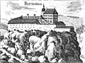 Rottenegg Castle, now ruined
 -
 Schloss Eschelberg, built in 1596
 -
 Schloss Eschelberg forest house
 -
 Medieval mill house
 -
 Former prison


References
- ^ "Dauersiedlungsraum der Gemeinden Politischen Bezirke und Bundesländer - Gebietsstand 1.1.2018". Statistics Austria. Retrieved 10 March 2019.
- ^ "Einwohnerzahl 1.1.2018 nach Gemeinden mit Status, Gebietsstand 1.1.2018". Statistics Austria. Retrieved 9 March 2019.
- ^ "Oberösterreich unbewegliche und archäologische Denkmale unter Denkmalschutz" (PDF). Bundesdenkmalamtes Österreich. 28 June 2013. p. 136.
Wikimedia Commons has media related to Sankt Gotthard im Mühlkreis.
- v
- t
- e
Municipalities in the district of Urfahr-Umgebung
- Alberndorf in der Riedmark
- Altenberg bei Linz
- Bad Leonfelden
- Eidenberg
- Engerwitzdorf
- Feldkirchen an der Donau
- Gallneukirchen
- Goldwörth
- Gramastetten
- Haibach im Mühlkreis
- Hellmonsödt
- Herzogsdorf
- Kirchschlag bei Linz
- Lichtenberg
- Oberneukirchen
- Ottenschlag im Mühlkreis
- Ottensheim
- Puchenau
- Reichenau im Mühlkreis
- Reichenthal
- Sankt Gotthard im Mühlkreis
- Schenkenfelden
- Sonnberg im Mühlkreis
- Steyregg
- Vorderweißenbach
- Walding
- Zwettl an der Rodl
Authority control databases | |
|---|---|
| International |
|
| National |
|
 | This Upper Austria location article is a stub. You can help Wikipedia by expanding it. |
- v
- t
- e


