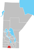
Rural Municipality of Argyle
Argyle is a rural municipality in the province of Manitoba in Western Canada. It was incorporated on 15 August 1881 and is named after John Campbell, 9th Duke of Argyll who was the fourth Governor General of Canada.
Baldur is the largest community in the municipality, which is in southwestern Manitoba between Brandon and Portage la Prairie.
Communities
- Baldur
- Glenora
- Greenway
- Neelin
Demographics
In the 2021 Census of Population conducted by Statistics Canada, Argyle had a population of 994 living in 398 of its 515 total private dwellings, a change of -3% from its 2016 population of 1,025. With a land area of 768.63 km2 (296.77 sq mi), it had a population density of 1.3/km2 (3.3/sq mi) in 2021.[1]
See also
References
- ^ "Population and dwelling counts: Canada, provinces and territories, and census subdivisions (municipalities), Manitoba". Statistics Canada. February 9, 2022. Retrieved February 20, 2022.
- Manitoba Historical Society - Rural Municipality of Argyle
- Map of Argyle R.M. at Statcan
- Baldur - R.M. Profile
External links
Official website
- v
- t
- e
| Former towns |
|---|

| Former villages |
|---|
- Argyle
- Cartwright–Roblin
- Lorne (part)
- Louise
- Pembina
| Former RMs |
|---|
 | This Manitoba location article is a stub. You can help Wikipedia by expanding it. |
- v
- t
- e


