Qujing
Prefecture-level city in Yunnan, People's Republic of China
Qujing 曲靖市 Kutsing | |
|---|---|
Prefecture-level city | |
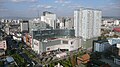
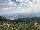 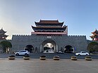 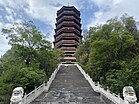 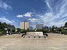 Urban skyline, South City Gate Jingning Pagoda, Zhujiangyuan Square | |
 Location of Qujing in Yunnan | |
| Coordinates (Qujing municipal government): 25°29′28″N 103°47′46″E / 25.491°N 103.796°E / 25.491; 103.796 | |
| Country | People's Republic of China |
| Province | Yunnan |
| Admin HQ | Qilin |
| Government | |
| • Secretary | Li Wenrong |
| • Mayor | Dong Baotong |
| Area | |
| • Prefecture-level city | 29,855 km2 (11,527 sq mi) |
| • Urban (2018)[1] | 148 km2 (57 sq mi) |
| • Metro | 1,442 km2 (557 sq mi) |
| Elevation | 1,873 m (6,145 ft) |
| Population (2018 estimation)[2] | |
| • Prefecture-level city | 6,155,400 |
| • Density | 210/km2 (530/sq mi) |
| • Urban | 1,432,500 |
| • Urban density | 9,700/km2 (25,000/sq mi) |
| • Metro | 1,432,500 |
| • Metro density | 990/km2 (2,600/sq mi) |
| GDP[3] | |
| • Prefecture-level city | CN¥ 380.2 billion US$ 56.1 billion |
| • Per capita | CN¥ 66,373 US$9,790 |
| Time zone | UTC+8 (China Standard) |
| Postal code | 655000 |
| Area code | 0874 |
| ISO 3166 code | CN-YN-03 |
| Website | www |
Qujing (Chinese: 曲靖; pinyin: Qǔjìng) is a prefecture-level city in the east of Yunnan province, China, bordering Guizhou province to the east and the Guangxi Zhuang Autonomous Region to the southeast; thus, it was called "Key between Yunnan and Guizhou" (滇黔锁钥) and "Throat of Yunnan" (云南咽喉) in the past. It is part of the Central Yunnan Metropolitan Region plan (滇中城市群规划) in effect for 2016–49.[4] Its administrative population is 6,047,000 according to a 2015 estimate, of whom, 1,408,500 reside in the metro area, which contains Qilin District, Zhanyi District and Malong District. During the 11th National Five-Year Plan period, the government of Qujing planned to develop the city into the "big city at the origin of the Pearl River" (珠江源大城市) in the following decades, including increasing the built-up urban area to past 100 km2 (39 sq mi) and the urban population to surpass 1 million by 2020, the second in Yunnan, after Kunming.[5]
Geography and climate

Qujing is located in the east of Yunnan province, about 130 kilometres (81 mi) east of Kunming, the provincial capital. Like much of the central and eastern parts of the province, it is part of the Yunnan-Guizhou Plateau.
Tempered by the low latitude and moderate elevation, Qujing has a mild subtropical highland climate (Köppen Cwb), with short, mild, dry winters, and warm, rainy summers. Frost may occur in winter but the days still generally warm up to around 15 °C (59 °F). During summer, a majority of the days features some rainfall, and daytime temperatures rise to 25 °C (77 °F). A great majority of the year's rainfall occurs from June to October.
| Climate data for Qujing (1991–2020 normals, extremes 1971–2010) | |||||||||||||
|---|---|---|---|---|---|---|---|---|---|---|---|---|---|
| Month | Jan | Feb | Mar | Apr | May | Jun | Jul | Aug | Sep | Oct | Nov | Dec | Year |
| Record high °C (°F) | 24.1 (75.4) | 26.2 (79.2) | 29.3 (84.7) | 31.9 (89.4) | 33.2 (91.8) | 32.1 (89.8) | 30.9 (87.6) | 30.3 (86.5) | 30.9 (87.6) | 27.3 (81.1) | 25.4 (77.7) | 24.6 (76.3) | 33.2 (91.8) |
| Mean daily maximum °C (°F) | 15.3 (59.5) | 17.5 (63.5) | 21.6 (70.9) | 24.4 (75.9) | 25.5 (77.9) | 25.4 (77.7) | 25.3 (77.5) | 25.4 (77.7) | 23.6 (74.5) | 20.6 (69.1) | 18.2 (64.8) | 15.0 (59.0) | 21.5 (70.7) |
| Daily mean °C (°F) | 8.6 (47.5) | 10.6 (51.1) | 14.4 (57.9) | 17.5 (63.5) | 19.3 (66.7) | 20.3 (68.5) | 20.5 (68.9) | 20.2 (68.4) | 18.4 (65.1) | 15.5 (59.9) | 12.2 (54.0) | 8.8 (47.8) | 15.5 (59.9) |
| Mean daily minimum °C (°F) | 4.2 (39.6) | 5.8 (42.4) | 9.2 (48.6) | 12.4 (54.3) | 15.0 (59.0) | 17.0 (62.6) | 17.4 (63.3) | 17.0 (62.6) | 15.2 (59.4) | 12.5 (54.5) | 8.3 (46.9) | 4.9 (40.8) | 11.6 (52.8) |
| Record low °C (°F) | −6.2 (20.8) | −9.2 (15.4) | −5.8 (21.6) | 0.3 (32.5) | 3.8 (38.8) | 9.4 (48.9) | 9.0 (48.2) | 8.7 (47.7) | 5.3 (41.5) | 1.1 (34.0) | −3.5 (25.7) | −8.7 (16.3) | −9.2 (15.4) |
| Average precipitation mm (inches) | 26.8 (1.06) | 17.2 (0.68) | 23.8 (0.94) | 35.5 (1.40) | 89.9 (3.54) | 192.2 (7.57) | 172.2 (6.78) | 139.9 (5.51) | 99.7 (3.93) | 86.3 (3.40) | 30.5 (1.20) | 18.3 (0.72) | 932.3 (36.73) |
| Average precipitation days (≥ 0.1 mm) | 6.8 | 6.6 | 6.6 | 8.2 | 12.1 | 17.1 | 17.9 | 16.8 | 13.0 | 13.3 | 6.6 | 6.6 | 131.6 |
| Average snowy days | 2.7 | 1.8 | 0.4 | 0 | 0 | 0 | 0 | 0 | 0 | 0 | 0.2 | 1.1 | 6.2 |
| Average relative humidity (%) | 65 | 58 | 53 | 55 | 63 | 74 | 78 | 76 | 76 | 78 | 71 | 70 | 68 |
| Mean monthly sunshine hours | 179.0 | 196.1 | 236.5 | 236.1 | 197.9 | 133.1 | 130.1 | 148.7 | 126.5 | 127.3 | 165.0 | 158.3 | 2,034.6 |
| Percent possible sunshine | 54 | 61 | 63 | 61 | 48 | 32 | 31 | 37 | 35 | 36 | 51 | 49 | 47 |
| Source 1: China Meteorological Administration[6][7] | |||||||||||||
| Source 2: Weather China[8] | |||||||||||||
Transport
Qujing is linked to Kunming by the National Highway 320. Drive time is about three hours. The transportation system in Qujing is well developed. You can access almost every corner of the city by way of the Kun Qu Freeway. Buses to Kunming depart from Qujing Bus Station every half hour, the trip takes about three hours. The bus station also provides transportation to Dali, Honghezhou and other destinations around Qujing. Taxi and buses are available in Qujing. The base rate of a taxi is RMB 7 for the first 2.5 km (1.6 mi).
Two train routes, Guizhou to Kunming and Nanning to Kunming, run through eight towns in Qujing each day. It takes one and a half hours to get from Qujing to Kunming by express. After Shanghai–Kunming high-speed railway completed in December 2016, it takes 45 minutes to reach Kunming South High-speed Train Station and an hour to reach Guiyang North High-speed Train Station from Qujing North High-speed Train Station. There is a plan for a speed train to run between Chengdu and Nanning by the year 2015, which will make the trip from Kunming to Qujing only 30 minutes long.
Administrative divisions

The government seat is located in Qilin District.
| Map | |||||
|---|---|---|---|---|---|
 Qilin Zhanyi Malong Luliang County Shizong County Luoping County Fuyuan County Huize County Xuanwei (city) | |||||
| Name | Hanzi | Hanyu Pinyin | Population (2015) | Area (km2) | Density (/km2) |
| Qilin District | 麒麟区 | Qílín Qū | 767,300 | 1,552.92 | 493 |
| Zhanyi District | 沾益区 | Zhānyì Qū | 448,500 | 2,801.27 | 160 |
| Malong District | 马龙区 | Mǎlóng Qū | 192,700 | 1,600.34 | 120 |
| Xuanwei City | 宣威市 | Xuānwēi Shì | 1,352,100 | 6,053.2 | 222 |
| Fuyuan County | 富源县 | Fùyuán Xiàn | 741,700 | 3,235.4 | 229 |
| Luoping County | 罗平县 | Luópíng Xiàn | 405,100 | 3,025.35 | 187 |
| Shizong County | 师宗县 | Shīzōng Xiàn | 405,100 | 2,741.66 | 147 |
| Luliang County | 陆良县 | Lùliáng Xiàn | 638,800 | 2,010.04 | 317 |
| Huize County | 会泽县 | Huìzé Xiàn | 934,800 | 5,883.93 | 159 |
Economy

In 2016, total GDP was of 177.5 billion Yuan, and the GDP per capita of: 27044 yuans.
Tobacco, automobiles, power generation and chemical engineering are the main industries in Qujing.
- Qujing Economic and Technological Development Zone
Qujing Economic and Technological Development Zone (QETDZ) is a provincial development zone approved by Yunnan Provincial Government in August 1992. It is located in the east of urban Qujing, the second largest city in Yunnan in terms of economic strengths. The location of the development zone is the economic, political and cultural center of Qujing. As an agency under Qujing municipal Party committee and municipal government, the administrative commission of QETDZ functions as an economy supervising body at the prefecture level and an administration body at the county level. It has 106 km2 (41 sq mi) under its jurisdiction. It shoulders the task of building a new 40-square-kilometer city area and providing service for a population of 400,000 in the upcoming 10 years.[9]
Demography
Among the resident population, the Han population is 5,442,131, accounting for 92.95% of the total population; the ethnic minorities population is 412,924, accounting for 7.1% of the total population.
| National name | Han | Yi | Hui | Hmong | Zhuang | Buyi | Shui | Bai | Yao | Mongol | Others |
|---|---|---|---|---|---|---|---|---|---|---|---|
| Population | 5442014 | 225245 | 68252 | 33518 | 30794 | 29941 | 6710 | 5259 | 2349 | 2169 | 8804 |
| Proportion of total population (%) | 92.95 | 3.85 | 1.17 | 0.57 | 0.53 | 0.51 | 0.11 | 0.09 | 0.04 | 0.04 | 0.15 |
| Proportion of minority population (%) | --- | 54.53 | 16.52 | 8.11 | 7.46 | 7.25 | 1.62 | 1.27 | 0.57 | 0.53 | 2.13 |
Sites of interest
- Jiulong Waterfall (Nine Dragons Waterfall) in Luoping County
- Tiansheng Cave, formerly Xianren Dong (Fairy Cave, although some translate it as Celestial Being Cave)
References
- ^ Cox, W (2018). Demographia World Urban Areas. 14th Annual Edition (PDF). St. Louis: Demographia. p. 85.
- ^ "China: Yúnnán (Prefectures, Cities, Districts and Counties) - Population Statistics, Charts and Map".
- ^ 云南省统计局、国家统计局云南调查总队 (December 2023). 《云南统计年鉴-2023》. 中国统计出版社. ISBN 978-7-5037-9653-1.
- ^ 滇中城市群规划(2016-2049年). yncityplan.com (in Chinese (China)). Retrieved 2020-04-26.
- ^ 曲靖"珠江源大城市"或将降级为中等城市 - 珠江网讯 - 曲靖市人民政府门户网 (in Chinese (China)). Qujiang People's Government. 2014-10-14. Retrieved 2020-04-26.
- ^ 中国气象数据网 – WeatherBk Data (in Simplified Chinese). China Meteorological Administration. Retrieved 10 April 2023.
- ^ 中国气象数据网 (in Simplified Chinese). China Meteorological Administration. Retrieved 10 April 2023.
- ^ 曲靖 - 气象数据 -中国天气网 (in Chinese). Weather China. Retrieved 21 November 2022.
- ^ RightSite.asia | Qujing Economic and Technological Development Zone
- ^ Yunnan Provincial Census Office, Yunnan Provincial Bureau of Statistics (September 2012). "Yunnan Provincial Census Data in 2010". China Statistics Press. ISBN 978-7-5037-6548-3.
External links
- Qujing City Official WebSite
- Qujing News Network
- Qujing in Yunnan
- Qujing, Yunnan - introduction
Yunnan topics | |
| General | |
| Geography | |
| Education | |
| Culture | |
| Cuisine |
|
| Visitor attractions | |
| |


Largest cities in Yunnan Source: China Urban Construction Statistical Yearbook 2018 Urban Population and Urban Temporary Population | |||||||||||||||||||||||||||||||||||||||||||||||||||||||||||||||||||||||
|---|---|---|---|---|---|---|---|---|---|---|---|---|---|---|---|---|---|---|---|---|---|---|---|---|---|---|---|---|---|---|---|---|---|---|---|---|---|---|---|---|---|---|---|---|---|---|---|---|---|---|---|---|---|---|---|---|---|---|---|---|---|---|---|---|---|---|---|---|---|---|---|
| |||||||||||||||||||||||||||||||||||||||||||||||||||||||||||||||||||||||


Authority control databases | |
|---|---|
| International |
|
| National |
|
| Geographic |
|


