Quebrada de Humahuaca
You can help expand this article with text translated from the corresponding article in Spanish. (November 2012) Click [show] for important translation instructions.
- View a machine-translated version of the Spanish article.
- Machine translation, like DeepL or Google Translate, is a useful starting point for translations, but translators must revise errors as necessary and confirm that the translation is accurate, rather than simply copy-pasting machine-translated text into the English Wikipedia.
- Do not translate text that appears unreliable or low-quality. If possible, verify the text with references provided in the foreign-language article.
- You must provide copyright attribution in the edit summary accompanying your translation by providing an interlanguage link to the source of your translation. A model attribution edit summary is
Content in this edit is translated from the existing Spanish Wikipedia article at [[:es:Quebrada de Humahuaca]]; see its history for attribution. - You may also add the template
{{Translated|es|Quebrada de Humahuaca}}to the talk page. - For more guidance, see Wikipedia:Translation.
UNESCO World Heritage Site in Jujuy Province, Argentina
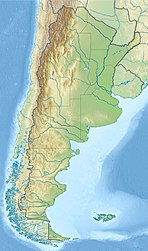

Location of Quebrada de Humahuaca in Argentina
The Quebrada de Humahuaca is a narrow mountain valley located in the province of Jujuy in northwest Argentina, 1,649 km (1,025 mi) north of Buenos Aires (23°11′59″S 65°20′56″W / 23.19972°S 65.34889°W / -23.19972; -65.34889). It is about 155 km (96 mi) long, oriented north–south, bordered by the Altiplano in the west and north, by the Sub-Andean hills in the east, and by the warm valleys (Valles Templados) in the south.
The name quebrada (literally "broken") translates as a deep valley or ravine. It receives its name from Humahuaca, a small city of 11,000 inhabitants. The Grande River (Río Grande), which is dry in winter, flows copiously through the Quebrada in the summer.
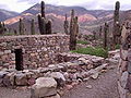
The region has always been a crossroads for economic, social and cultural communication. It has been populated for at least 10,000 years, since the settlement of the first hunter-gatherers, which is evidenced by substantial prehistoric remains. In particular, many stone-walled agricultural terraces, thought to originate more than 1500 years ago, are found throughout the region and are still in use today.[1] The field system links a series of fortified towns called pucaras.[2] The valley was later a caravan road for the Inca Empire in the 15th century, then an important link between the Viceroyalty of the Río de la Plata and the Viceroyalty of Peru, as well as a stage for many battles of the Spanish War of Independence.[3]
The Quebrada de Humahuaca was designated a protected landscape in 2000.[4] It was made a UNESCO World Heritage Site on 2 July 2003.
-
-
-
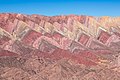
 Cerro de los Siete Colores, Purmamarca


See also
- Iruya
- Abra Pampa
- Hornillos de Eresma
- Huacalera
- Humahuaca
- La Quiaca
- Maimará
- Purmamarca
- Cerro de los Siete Colores
- Pucará de Tilcara
- Tilcara
- Volcán
- Serranía de Hornocal
References
- ^ "Quebrada de Humahuaca". UNESCO World Heritage List. UNESCO. Retrieved 14 March 2021.
- ^ "Quebrada de Humahuaca". UNESCO World Heritage List. UNESCO. Retrieved 14 March 2021.
- ^ "Quebrada de Humahuaca". UNESCO World Heritage List. UNESCO. Retrieved 14 March 2021.
- ^ UNEP-WCMC (2022). Protected Area Profile for Quebrada de Humahuaca from the World Database of Protected Areas. Accessed 11 April 2022. [1]
External links
- UNESCO World Heritage Centre - Description of the site.
- Jujuy Province - Official website (in Spanish).
- Municipal information: Municipal Affairs Federal Institute (IFAM), Municipal Affairs Secretariat, Ministry of Interior, Argentina. (in Spanish)
- Pictures from Humahuaca
- v
- t
- e
- Quebrada de Humahuaca
- Talampaya National Park
- Inca road system1

- The Architectural Work of Le Corbusier
- Jesuit Missions of the Guaranis2
- Iguazú National Park
Authority control databases | |
|---|---|
| International |
|
| National |
|
 | This article about a place in Jujuy Province, Argentina is a stub. You can help Wikipedia by expanding it. |
- v
- t
- e


