Poppenricht
Municipality in Bavaria, Germany

Flag

Coat of arms
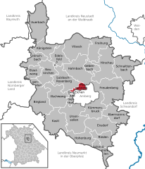
Location of Poppenricht within Amberg-Sulzbach district
(2022-12-31)[2]
92284
Poppenricht is a municipality in the district of Amberg-Sulzbach in Bavaria in Germany.
Geography
Apart from Poppenricht the municipality consists of the following villages:[3]
- Altmannshof
- Häringlohe
- Laubmühle
- Speckshof
- Traßlberg
- Wirnsricht
- Witzlhof
Twin towns
 Krems, Austria

Notable people
References
- ^ Liste der ersten Bürgermeister/Oberbürgermeister in kreisangehörigen Gemeinden, Bayerisches Landesamt für Statistik, accessed 19 July 2021.
- ^ Genesis Online-Datenbank des Bayerischen Landesamtes für Statistik Tabelle 12411-003r Fortschreibung des Bevölkerungsstandes: Gemeinden, Stichtag (Einwohnerzahlen auf Grundlage des Zensus 2011).
- ^ "Ortsteile mit Postleitzahl". Retrieved 2024-02-15.
Wikimedia Commons has media related to Poppenricht.
- v
- t
- e
Towns and municipalities in Amberg-Sulzbach
- Ammerthal
- Auerbach in der Oberpfalz
- Birgland
- Ebermannsdorf
- Edelsfeld
- Ensdorf
- Etzelwang
- Freihung
- Freudenberg
- Gebenbach
- Hahnbach
- Hirschau
- Hirschbach
- Hohenburg
- Illschwang
- Kastl
- Königstein
- Kümmersbruck
- Neukirchen bei Sulzbach-Rosenberg
- Poppenricht
- Rieden
- Schmidmühlen
- Schnaittenbach
- Sulzbach-Rosenberg
- Ursensollen
- Vilseck
- Weigendorf

Authority control databases | |
|---|---|
| International |
|
| National |
|
 | This Amberg-Sulzbach location article is a stub. You can help Wikipedia by expanding it. |
- v
- t
- e


