Pitten
Place in Lower Austria, Austria

Coat of arms
(2018-01-01)[2]
2823
Pitten is a Market Municipality in the district of Neunkirchen in the Austrian federal state of Lower Austria.
Geography
Pitten lies in the northern part of the "Bucklige Welt".
Population
| Year | Pop. | ±% |
|---|---|---|
| 1869 | 1,572 | — |
| 1880 | 1,850 | +17.7% |
| 1890 | 1,867 | +0.9% |
| 1900 | 2,123 | +13.7% |
| 1910 | 2,340 | +10.2% |
| 1923 | 2,491 | +6.5% |
| 1934 | 2,577 | +3.5% |
| 1939 | 2,469 | −4.2% |
| 1951 | 2,692 | +9.0% |
| 1961 | 2,540 | −5.6% |
| 1971 | 2,597 | +2.2% |
| 1981 | 2,498 | −3.8% |
| 1991 | 2,460 | −1.5% |
| 2001 | 2,473 | +0.5% |
| 2011 | 2427 2012 109000 | — |
-
 Parsonage
 -
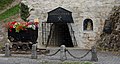 Closed down St. Georgi tunnel


References
- v
- t
- e
Municipalities in the district of Neunkirchen
- Altendorf
- Aspang-Markt
- Aspangberg-Sankt Peter
- Breitenau
- Breitenstein
- Buchbach
- Bürg-Vöstenhof
- Edlitz
- Enzenreith
- Feistritz am Wechsel
- Gloggnitz
- Grafenbach-Sankt Valentin
- Grimmenstein
- Grünbach am Schneeberg
- Höflein an der Hohen Wand
- Kirchberg am Wechsel
- Mönichkirchen
- Natschbach-Loipersbach
- Neunkirchen
- Otterthal
- Payerbach
- Pitten
- Prigglitz
- Puchberg am Schneeberg
- Raach am Hochgebirge
- Reichenau an der Rax
- Scheiblingkirchen-Thernberg
- Schottwien
- Schrattenbach
- Schwarzau am Steinfeld
- Schwarzau im Gebirge
- Seebenstein
- Semmering
- Sankt Corona am Wechsel
- Sankt Egyden am Steinfeld
- Ternitz
- Thomasberg
- Trattenbach
- Warth
- Wartmannstetten
- Willendorf
- Wimpassing im Schwarzatale
- Würflach
- Zöbern
Authority control databases | |
|---|---|
| International |
|
| National |
|
 | This Lower Austria location article is a stub. You can help Wikipedia by expanding it. |
- v
- t
- e


