Ouder-Amstel
Municipality in North Holland, Netherlands

Flag

Coat of arms

Location in North Holland
(January 2021)[4]
1115, 1190–1191
Ouder-Amstel (Dutch pronunciation: [ˌʌudər ˈɑmstəl] ⓘ) is a municipality in the Netherlands on the river Amstel, in the province of North Holland. It is 5 km (3.1 mi) south of the centre of Amsterdam.
Population centres
The municipality of Ouder-Amstel consists of the towns and villages of Duivendrecht, Ouderkerk aan de Amstel, Waver.
Topography

Map of the municipality of Ouder-Amstel, June 2015
Local government
The municipal council of Ouder-Amstel consists of 15 seats, which at the 2022 municipal election divided as follows:[5]
- Ouder-Amstel Anders - 3 seats
- VVD - 3 seats
- Natuurlijk Belang - 3 seats
- D66 - 2 seats
- PvdA - 2 seats
- GroenLinks - 2 seats
Radio station
The local radio station for Duivendrecht is Jamm fm 104.9 Smooth & Funky.[6]
Notable people
- Gijsbrecht IV of Amstel (ca.1235–ca.1303) a powerful lord and member of the Van Aemstel family.
- Wim Eijk (born 1953 in Duivendrecht) a Dutch prelate of the Catholic Church, a cardinal and Archbishop of Utrecht
- Femke Wolting (born 1970 in Ouder-Amstel) a Dutch independent new media producer[7]
- Meindert Klem (born 1987 in Ouderkerk aan de Amstel) a rower, competed in the 2008 and 2012 Summer Olympics
Gallery
-
 "De Sollenburg" Ronde Hoep west 49
 -
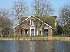
 Water tower, De Oude Molen gunpowder factory
 -
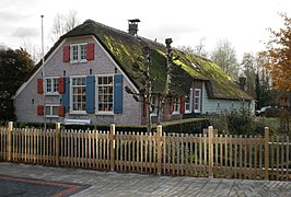 Ouderkerk aan de Amstel De Haegh Farm
 -
 Pontveer Ouderkerk on the Amstel
 -
 Ouderkerk ad Amstel, view of the Ronde Hoep


References
- ^ "Collegeleden" [Members of the board] (in Dutch). Gemeente Ouder-Amstel. Retrieved 8 May 2024.
{{cite web}}: CS1 maint: url-status (link) - ^ "Kerncijfers wijken en buurten 2020" [Key figures for neighbourhoods 2020]. StatLine (in Dutch). CBS. 24 July 2020. Retrieved 19 September 2020.
- ^ "Postcodetool for 1191BD". Actueel Hoogtebestand Nederland (in Dutch). Het Waterschapshuis. Retrieved 20 March 2014.
- ^ "Bevolkingsontwikkeling; regio per maand" [Population growth; regions per month]. CBS Statline (in Dutch). CBS. 1 January 2021. Retrieved 2 January 2022.
- ^ "Ouder-Amstel municipal election 2022". verkiezingsuitslagen.nl (in Dutch). 16 March 2022. Retrieved 8 May 2024.
- ^ "JammFM Smooth & Funky 104.9". JammFM 104.9.
- ^ IMDb Database retrieved 01 January 2020
External links
 Media related to Ouder-Amstel at Wikimedia Commons
- Official website
Places adjacent to Ouder-Amstel | ||||||||||||||||
|---|---|---|---|---|---|---|---|---|---|---|---|---|---|---|---|---|
| ||||||||||||||||


- v
- t
- e
Municipalities of North Holland
- Aalsmeer
- Alkmaar
- Amstelveen
- Amsterdam
- Bergen
- Beverwijk
- Blaricum
- Bloemendaal
- Castricum
- Den Helder
- Diemen
- Dijk en Waard
- Drechterland
- Edam-Volendam
- Enkhuizen
- Gooise Meren
- Haarlem
- Haarlemmermeer
- Heemskerk
- Heemstede
- Heiloo
- Hilversum
- Hollands Kroon
- Hoorn
- Huizen
- Koggenland
- Landsmeer
- Laren
- Medemblik
- Oostzaan
- Opmeer
- Ouder-Amstel
- Purmerend
- Schagen
- Stede Broec
- Texel
- Uitgeest
- Uithoorn
- Velsen
- Waterland
- Wijdemeren
- Wormerland
- Zaanstad
- Zandvoort

- See also
- Netherlands
- Provinces
- Municipalities
 | This North Holland location article is a stub. You can help Wikipedia by expanding it. |
- v
- t
- e


