OL postcode area
Postcode area within the United Kingdom
53°34′59″N 2°07′30″W / 53.583°N 2.125°W / 53.583; -2.125
OL
Oldham
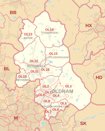
The OL postcode area, also known as the Oldham postcode area,[2] is a group of sixteen postcode districts in north-west England, within seven post towns. These cover eastern Greater Manchester (including Oldham, Rochdale, Ashton-under-Lyne, Heywood and Littleborough), plus small parts of east Lancashire (including Bacup) and western West Yorkshire (including Todmorden).
Coverage
The approximate coverage of the postcode districts are:
| Postcode district | Post town | Coverage | Local authority area(s) |
|---|---|---|---|
| OL1 | OLDHAM | Chadderton, Higginshaw, Oldham | Oldham |
| OL2 | OLDHAM | Heyside, Royton, Shaw | Oldham |
| OL3 | OLDHAM | Delph, Denshaw, Diggle, Dobcross, Greenfield, Uppermill | Oldham |
| OL4 | OLDHAM | Austerlands, Grasscroft, Grotton, Lees, Lydgate, Oldham, Scouthead, Springhead, Waterhead | Oldham |
| OL5 | ASHTON-UNDER-LYNE | Mossley, Mossley Cross | Tameside |
| OL6 | ASHTON-UNDER-LYNE | Ashton-under-Lyne (centre and east) | Tameside |
| OL7 | ASHTON-UNDER-LYNE | Ashton-under-Lyne (west) | Tameside |
| OL8 | OLDHAM | Bardsley, Oldham | Oldham |
| OL9 | OLDHAM | Chadderton, Oldham, Westwood, Freehold | Oldham |
| OL10 | HEYWOOD | Heywood | Rochdale |
| OL11 | ROCHDALE | Rochdale (south), Ashworth, Balderstone, Castleton, Norden | Rochdale |
| OL12 | ROCHDALE | Rochdale (north), Buckley, Facit, Great Howarth, Healy, Hurstead, Shawforth, Wardle, Whitworth | Rochdale, Rossendale |
| OL13 | BACUP | Bacup, Britannia, Stacksteads | Rossendale |
| OL14 | TODMORDEN | Cornholme, Todmorden, Eastwood, Walsden | Calderdale |
| OL15 | LITTLEBOROUGH | Littleborough, Shore, Smithybridge, Summit | Rochdale |
| OL16 | LITTLEBOROUGH | non-geographic[3][4] | |
| OL16 | ROCHDALE | Rochdale (east), Burnedge, Firgrove, Hurstead, Milnrow, Smallbridge, Thornham | Rochdale |
| OL95 | OLDHAM | British Gas | non-geographic[3] |
Map
KML file (edit • help)
Template:Attached KML/OL postcode area
KML is from Wikidata
See also
References
- ^ "ONS Postcode Directory Version Notes" (ZIP). National Statistics Postcode Products. Office for National Statistics. May 2020. Table 2. Retrieved 19 June 2020. Coordinates from mean of unit postcode points, "Code-Point Open". OS OpenData. Ordnance Survey. February 2012. Retrieved 21 April 2012.
- ^ Royal Mail, Address Management Guide, (2004)
- ^ a b "Non Geographic Codes" (PDF). Royal Mail Address Management Unit. July 2012. Archived from the original (PDF) on 16 September 2012. Retrieved 20 December 2012.
- ^ "New sectors and localities to 14 December 2012" (PDF). Royal Mail Address Management Unit. 20 December 2012. Archived from the original (PDF) on 2 February 2015. Retrieved 20 December 2012.
External links
- Royal Mail's Postcode Address File
- A quick introduction to Royal Mail's Postcode Address File (PAF)
- v
- t
- e
- AB
- AL
- B
- BA
- BB
- BD
- BH
- BL
- BN
- BR
- BS
- BT
- CA
- CB
- CF
- CH
- CM
- CO
- CR
- CT
- CV
- CW
- DA
- DD
- DE
- DG
- DH
- DL
- DN
- DT
- DY
- E
- EC
- EH
- EN
- EX
- FK
- FY
- G
- GL
- GU
- HA
- HD
- HG
- HP
- HR
- HS
- HU
- HX
- IG
- IP
- IV
- KA
- KT
- KW
- KY
- L
- LA
- LD
- LE
- LL
- LN
- LS
- LU
- M
- ME
- MK
- ML
- N
- NE
- NG
- NN
- NP
- NR
- NW
- OL
- OX
- PA
- PE
- PH
- PL
- PO
- PR
- RG
- RH
- RM
- S
- SA
- SE
- SG
- SK
- SL
- SM
- SN
- SO
- SP
- SR
- SS
- ST
- SW
- SY
- TA
- TD
- TF
- TN
- TQ
- TR
- TS
- TW
- UB
- W
- WA
- WC
- WD
- WF
- WN
- WR
- WS
- WV
- YO
- ZE
- Related UK lists: Postcode districts
- Post towns
- Postal counties
- London postal district


