Niederelbe
River in Germany
| Niederelbe | |
|---|---|
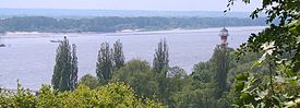 The Lower Elbe at Rissen, Hamburg | |
| Location | |
| Country | Germany |
| State | Hamburg–Cuxhaven |
| Physical characteristics | |
| Length | 108 km (67 mi) |
| Width | |
| • minimum | 2 km (1.2 mi) |
| • maximum | 18 km (11 mi) |
| Depth | |
| • maximum | 30 m (98 ft) |
| Basin features | |
| River system | Elbe |

The Niederelbe (i.e. Lower Elbe) is a 108 kilometers (67 miles) long section of the river Elbe, from western Hamburg downstream to its mouth into the North Sea near Cuxhaven. Starting at Mühlenberger Loch [de; nds] (or Elbe kilometer 634) near Finkenwerder, Hamburg, it gradually widens from 2 km (1.2 mi) to 18 km (11 mi). Once passing the Hamburg state border, the Niederelbe also forms the border between the states of Lower Saxony and Schleswig-Holstein.
The Niederelbe forms part of the Elbe section named the Unterelbe (i. e. Lower ("Under") Elbe), comprising all parts of the Elbe influenced by the North Sea's tides, starting further inland at the sluice in Geesthacht (or Elbe kilometer 586).
See also
External links
 Media related to Elbe in Hamburg at Wikimedia Commons
- v
- t
- e
This article related to a river in Schleswig-Holstein is a stub. You can help Wikipedia by expanding it. |
- v
- t
- e
This article related to a river in Lower Saxony is a stub. You can help Wikipedia by expanding it. |
- v
- t
- e


