Nebušice
Place in Czech Republic

Flag

Coat of arms
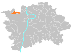
Location of Nebušice in Prague
(2015)
164 00
Nebušice is a district of Prague 6. It is situated northwest of the city center. It is connected with the city center by four bus lines, from bus station Bořislavka 161 and 312.
History
Nebušice was connected to Prague in 1968, before then it was a village.[1]
References
- ^ Poche, Jan (2001). Prahou krok za krokem. Prague: Paseka.
External links
Wikimedia Commons has media related to Nebušice.
- Webpage of Nebušice (Czech language)
- v
- t
- e
Districts and cadastral areas of Prague 

Former names shown in italics
districts
districts
- Běchovice
- Benice
- Březiněves
- Čakovice
- Ďáblice
- Dolní Chabry
- Dolní Měcholupy
- Dolní Počernice
- Dubeč
- Klánovice
- Koloděje
- Kolovraty
- Královice
- Křeslice
- Kunratice
- Libuš
- Lipence
- Lochkov
- Lysolaje
- Nebušice
- Nedvězí
- Petrovice
- Přední Kopanina
- Řeporyje
- Satalice
- Slivenec
- Suchdol
- Šeberov
- Štěrboholy
- Troja
- Újezd u Průhonic
- Velká Chuchle
- Vinoř
- Zbraslav
- Zličín
- Běchovice
- Benice
- Bohnice
- Braník
- Břevnov
- Březiněves
- Bubeneč
- Čakovice
- Černý Most
- Chodov
- Cholupice
- Čimice
- Ďáblice
- Dejvice
- Dolní Chabry
- Dolní Měcholupy
- Dolní Počernice
- Dubeč
- Háje
- Hájek
- Hloubětín
- Hlubočepy
- Hodkovičky
- Holešovice
- Holyně
- Horní Měcholupy
- Horní Počernice
- Hostavice
- Hostivař
- Hradčany
- Hrdlořezy
- Jinonice
- Josefov (Jewish Quarter)
- Kamýk
- Karlín
- Klánovice
- Kobylisy
- Koloděje
- Kolovraty
- Komořany
- Košíře
- Královice
- Krč
- Křeslice
- Kunratice
- Kyje
- Lahovice
- Letňany
- Lhotka
- Libeň
- Liboc
- Libuš
- Lipany
- Lipence
- Lochkov
- Lysolaje
- Malá Chuchle
- Malá Strana ("Lesser Town")
- Malešice
- Michle
- Miškovice
- Modřany
- Motol
- Nebušice
- Nedvězí u Říčan
- Nové Město ("New Town")
- Nusle
- Petrovice
- Písnice
- Pitkovice
- Podolí
- Přední Kopanina
- Prosek
- Radlice
- Radotín
- Řeporyje
- Řepy
- Ruzyně
- Satalice
- Sedlec
- Slivenec
- Smíchov
- Sobín
- Staré Město ("Old Town")
- Štěrboholy
- Stodůlky
- Strašnice
- Střešovice
- Střížkov
- Suchdol
- Točná
- Třebonice
- Třeboradice
- Troja
- Uhříněves
- Újezd nad Lesy
- Újezd (u Průhonic)
- Veleslavín
- Velká Chuchle
- Vinohrady
- Vinoř
- Vokovice
- Vršovice
- Vyšehrad
- Vysočany
- Záběhlice
- Zadní Kopanina
- Zbraslav
- Žižkov
- Zličín
| Authority control databases: National |
|
|---|
 | This Prague location article is a stub. You can help Wikipedia by expanding it. |
- v
- t
- e


