National Register of Historic Places listings in Madera County, California

This is a list of the National Register of Historic Places listings in Madera County, California.
This is intended to be a complete list of the properties and districts on the National Register of Historic Places in Madera County, California, United States. Latitude and longitude coordinates are provided for many National Register properties and districts; these locations may be seen together in an online map.[1]
There are 4 properties and districts listed on the National Register in the county.
This National Park Service list is complete through NPS recent listings posted May 3, 2024.[2]
Map all coordinates using OpenStreetMap
Download coordinates as:
- KML
- GPX (all coordinates)
- GPX (primary coordinates)
- GPX (secondary coordinates)
Current listings
| [3] | Name on the Register[4] | Image | Date listed[5] | Location | City or town | Description |
|---|---|---|---|---|---|---|
| 1 | Buck Camp Patrol Cabin |  | July 18, 2014 (#14000406) | Jct. of Buck Cr. & Buck Camp Tr. 37°33′47″N 119°29′23″W / 37.562991°N 119.489592°W / 37.562991; -119.489592 (Buck Camp Patrol Cabin) | Yosemite National Park | |
| 2 | Devils Postpile Cabin Site | Upload image | July 18, 2016 (#16000473) | Address Restricted | Devils Postpile National Monument | |
| 3 | Devils Postpile National Monument Ranger Cabin | 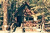 | December 8, 2015 (#15000859) | Minaret Summit Rd. 37°37′49″N 119°05′05″W / 37.6302°N 119.0846°W / 37.6302; -119.0846 (Devils Postpile National Monument Ranger Cabin) | Devils Postpile National Monument | |
| 4 | Madera County Courthouse |  | September 3, 1971 (#71000162) | 210 W. Yosemite Ave. 36°57′34″N 120°03′39″W / 36.959444°N 120.060833°W / 36.959444; -120.060833 (Madera County Courthouse) | Madera |
See also
Wikimedia Commons has media related to National Register of Historic Places in Madera County, California.
- List of National Historic Landmarks in California
- National Register of Historic Places listings in California
- California Historical Landmarks in Madera County, California
References
- ^ The latitude and longitude information provided in this table was derived originally from the National Register Information System, which has been found to be fairly accurate for about 99% of listings. Some locations in this table may have been corrected to current GPS standards.
- ^ National Park Service, United States Department of the Interior, "National Register of Historic Places: Weekly List Actions", retrieved May 3, 2024.
- ^ Numbers represent an alphabetical ordering by significant words. Various colorings, defined here, differentiate National Historic Landmarks and historic districts from other NRHP buildings, structures, sites or objects.
- ^ "National Register Information System". National Register of Historic Places. National Park Service. July 9, 2010.
- ^ The eight-digit number below each date is the number assigned to each location in the National Register Information System database, which can be viewed by clicking the number.
- v
- t
- e
- List of U.S. National Historic Landmarks by state:
- Alabama
- Alaska
- Arizona
- Arkansas
- California
- Colorado
- Connecticut
- Delaware
- Florida
- Georgia
- Hawaii
- Idaho
- Illinois
- Indiana
- Iowa
- Kansas
- Kentucky
- Louisiana
- Maine
- Maryland
- Massachusetts
- Michigan
- Minnesota
- Mississippi
- Missouri
- Montana
- Nebraska
- Nevada
- New Hampshire
- New Jersey
- New Mexico
- New York
- North Carolina
- North Dakota
- Ohio
- Oklahoma
- Oregon
- Pennsylvania
- Rhode Island
- South Carolina
- South Dakota
- Tennessee
- Texas
- Utah
- Vermont
- Virginia
- Washington
- West Virginia
- Wisconsin
- Wyoming
 National Register of Historic Places portal
 Category


Municipalities and communities of Madera County, California, United States | ||
|---|---|---|
County seat: Madera | ||
| Cities |  | |
| CDPs | ||
| Other unincorporated communities | ||
| Indian reservations | ||
| Ghost towns | ||
| Mining areas | ||
| ||


