National Register of Historic Places listings in Gallatin County, Kentucky

This is a list of the National Register of Historic Places listings in Gallatin County, Kentucky.
It is intended to be a complete list of the properties on the National Register of Historic Places in Gallatin County, Kentucky, United States. The locations of National Register properties for which the latitude and longitude coordinates are included below, may be seen in a map.[1]
There are 4 properties listed on the National Register in the county.
This National Park Service list is complete through NPS recent listings posted May 31, 2024.[2]
Map all coordinates using OpenStreetMap
Download coordinates as:
- KML
- GPX (all coordinates)
- GPX (primary coordinates)
- GPX (secondary coordinates)
Current listings
| [3] | Name on the Register | Image | Date listed[4] | Location | City or town | Description |
|---|---|---|---|---|---|---|
| 1 | Dr. Lucy Dupuy Montz House | 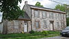 | March 30, 1978 (#78001333) | 200 W. High St. 38°47′00″N 84°54′17″W / 38.783333°N 84.904722°W / 38.783333; -84.904722 (Dr. Lucy Dupuy Montz House) | Warsaw | |
| 2 | Henry C. Peak House |  | April 10, 1980 (#80001530) | Sparta Pike 38°46′54″N 84°54′05″W / 38.781667°N 84.901389°W / 38.781667; -84.901389 (Henry C. Peak House) | Warsaw | |
| 3 | Benjamin F. Turley House |  | March 7, 1979 (#79000989) | 2.5 miles (4 km) north of Sparta on Kentucky Route 35 38°41′56″N 84°54′43″W / 38.698889°N 84.911806°W / 38.698889; -84.911806 (Benjamin F. Turley House) | Sparta | |
| 4 | Warsaw Historic District |  | July 29, 1982 (#82002699) | Roughly bounded by W. High, E. Franklin, Washington, Market, Main, 3rd, 4th, and Cross Sts. 38°46′55″N 84°54′02″W / 38.781944°N 84.900556°W / 38.781944; -84.900556 (Warsaw Historic District) | Warsaw |
See also
Wikimedia Commons has media related to National Register of Historic Places in Gallatin County, Kentucky.
- List of National Historic Landmarks in Kentucky
- National Register of Historic Places listings in Kentucky
References
- ^ The latitude and longitude information provided in this table was derived originally from the National Register Information System, which has been found to be fairly accurate for about 99% of listings. Some locations in this table may have been corrected to current GPS standards.
- ^ National Park Service, United States Department of the Interior, "National Register of Historic Places: Weekly List Actions", retrieved May 31, 2024.
- ^ Numbers represent an alphabetical ordering by significant words. Various colorings, defined here, differentiate National Historic Landmarks and historic districts from other NRHP buildings, structures, sites or objects.
- ^ The eight-digit number below each date is the number assigned to each location in the National Register Information System database, which can be viewed by clicking the number.
- v
- t
- e
- List of U.S. National Historic Landmarks by state:
- Alabama
- Alaska
- Arizona
- Arkansas
- California
- Colorado
- Connecticut
- Delaware
- Florida
- Georgia
- Hawaii
- Idaho
- Illinois
- Indiana
- Iowa
- Kansas
- Kentucky
- Louisiana
- Maine
- Maryland
- Massachusetts
- Michigan
- Minnesota
- Mississippi
- Missouri
- Montana
- Nebraska
- Nevada
- New Hampshire
- New Jersey
- New Mexico
- New York
- North Carolina
- North Dakota
- Ohio
- Oklahoma
- Oregon
- Pennsylvania
- Rhode Island
- South Carolina
- South Dakota
- Tennessee
- Texas
- Utah
- Vermont
- Virginia
- Washington
- West Virginia
- Wisconsin
- Wyoming
 National Register of Historic Places portal
 Category


Municipalities and communities of Gallatin County, Kentucky, United States | ||
|---|---|---|
County seat: Warsaw | ||
| Cities |  | |
| Unincorporated communities | ||
| Ghost town | ||
| Footnotes | ‡This populated place also has portions in an adjacent county or counties | |
| ||


