Nagybánhegyes
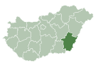
Place in Békés, Hungary
Nagybánhegyes | |
|---|---|
| Country |  Hungary Hungary |
| County | Békés |
| Area | |
| • Total | 42.26 km2 (16.32 sq mi) |
| Population (2015) | |
| • Total | 1,224[1] |
| • Density | 29/km2 (80/sq mi) |
| Time zone | UTC+1 (CET) |
| • Summer (DST) | UTC+2 (CEST) |
| Postal code | 5668 |
| Area code | 68 |
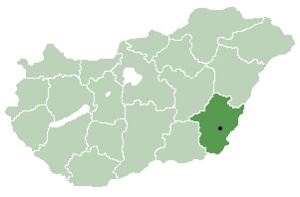
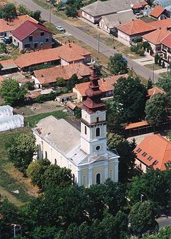
Nagybánhegyes (Slovak: Slovenský Bánhedeš, Hungarian: Nagy Bán-Hegyes) is a village in Békés County, in the Southern Great Plain region of south-east Hungary.
Geography
It covers an area of 42.26 km2 and has a population of 1224 people (2015).[1]
Other information
Nagybánhegyes is also the place where the mass-production of the Hungarian product, Pöttyös Túri Rudi was started in 1981.[citation needed]
References
- ^ a b Gazetteer of Hungary, 1st January 2015. Hungarian Central Statistical Office. 03/09/2015
See also
- Magyar-Bánhegyes ("Hungarian Bánhegyes")
- v
- t
- e
- Békéscsaba (county seat)

- Almáskamarás
- Biharugra
- Bucsa
- Békéssámson
- Bélmegyer
- Csabaszabadi
- Csanádapáca
- Csárdaszállás
- Dombiratos
- Ecsegfalva
- Gerendás
- Geszt
- Hunya
- Kamut
- Kardos
- Kardoskút
- Kaszaper
- Kertészsziget
- Kisdombegyház
- Kondoros
- Kunágota
- Kétsoprony
- Körösnagyharsány
- Köröstarcsa
- Körösújfalu
- Kötegyán
- Lőkösháza
- Magyarbánhegyes
- Magyardombegyház
- Medgyesbodzás
- Mezőgyán
- Murony
- Méhkerék
- Nagybánhegyes
- Nagykamarás
- Okány
- Pusztaföldvár
- Pusztaottlaka
- Sarkadkeresztúr
- Szabadkígyós
- Tarhos
- Telekgerendás
- Végegyháza
- Zsadány
- Örménykút
- Újszalonta
- History
- Geography
- Government
- Economy
- Culture
- Tourism
46°28′N 20°54′E / 46.467°N 20.900°E / 46.467; 20.900
 | This Békés County location article is a stub. You can help Wikipedia by expanding it. |
- v
- t
- e
  | This Hungarian history article is a stub. You can help Wikipedia by expanding it. |
- v
- t
- e


