Muff, Pennsylvania
Unincorporated community in Pennsylvania, United States
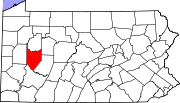
40°53′04″N 79°20′17″W / 40.88444°N 79.33806°W / 40.88444; -79.33806Muff is an unincorporated community in Armstrong County, Pennsylvania, United States.[1] The highest natural point in Armstrong County is located near Muff.[2]
A post office called Muff was established in 1879, and remained in operation until it was discontinued in 1908.[3] A variant name is "Snyderville".[1]
References
- ^ a b c "Muff". Geographic Names Information System. United States Geological Survey, United States Department of the Interior.
- ^ United States. Bureau of Soils; United States. Bureau of Plant Industry; United States. Bureau of Plant Industry, Soils, and Agricultural Engineering (1977). Soil survey. U.S. Dept. of Agriculture. p. 71.
{{cite book}}: CS1 maint: multiple names: authors list (link) - ^ "Armstrong County". Jim Forte Postal History. Retrieved October 1, 2014.
- v
- t
- e
Municipalities and communities of Armstrong County, Pennsylvania, United States
County seat: Kittanning
- Parker

- Apollo
- Applewold
- Atwood
- Dayton
- Elderton
- Ford City
- Ford Cliff
- Freeport
communities
- Adrian
- Belknap
- Cadogan
- Chickasaw
- Climax
- Cowansville
- Craigsville
- Deanville
- Echo
- Eddyville
- Frogtown
- Idaho
- Kellersburg
- Mahoning Furnace
- Maysville
- McCrea Furnace
- McGrann
- McGregor
- McVille
- McWilliams
- Milton
- Mosgrove
- Muff
- New Salem
- Nu Mine
- Oak Ridge
- Oscar
- Putneyville
- Rimer
- Seminole
- Shady Plain
- Slabtown
- South Bend
- Tidal
- West Valley
- Widnoon
- Pennsylvania portal
- United States portal
 | This Armstrong County, Pennsylvania state location article is a stub. You can help Wikipedia by expanding it. |
- v
- t
- e


