Montopoli di Sabina
Comune in Lazio, Italy

Coat of arms

Montopoli within the Province of Rieti
Location of Montopoli di Sabina

42°14′45″N 12°41′30″E / 42.24583°N 12.69167°E / 42.24583; 12.69167
(2011)[2]
02034
Montopoli di Sabina is a town and comune (municipality) in the Province of Rieti in the Italian region of Latium, located about 40 kilometres (25 mi) northeast of Rome and about 20 kilometres (12 mi) southwest of Rieti. In 2011, it had a population of 4,222.[2]
History
The town was first mentioned in 1055, in a document of Farfa Abbey. It is locally known as The Town of Privateers (Italian: Il paese dei Corsari).[3]
Geography
Montopoli, located in the southwestern corner of the province, at the borders with the one of Rome, borders with the municipalities of Castelnuovo di Farfa, Fara in Sabina, Fiano Romano (RM), Nazzano (RM), Poggio Mirteto, Salisano and Torrita Tiberina (RM). Its southwestern borders with Fiano are crossed by the Tiber river.[4]
Montopoli counts the hamlets (frazioni) of Bocchignano, Casenove, Colonnetta La Memoria, Ferruti, Granari, Granica, Ponte Sfondato, Ponticchio and Santa Maria.
Demographics

Main sights
- The Modern Automata Museum, founded in 2001, is located in the town
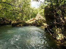
- The cyclopean masonry of Grotte di Torri is located nearby the village of Ponte Sfondato
Gallery
-
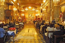 Interior of St. Michael's Church
 -
 The cyclopean masonry of Grotte di Torri
 -
 Panoramic view of Bocchignano
 -
 Remains of an ancient bridge over Farfa River at Ponte Sfondato


Transport
Nearest railway station, Poggio Mirteto, is 7 km far and lies in Poggio Mirteto Scalo. It is part of the Roman suburban railway line FL1 Orte–Fiumicino, a line that crosses the southwestern corner of the municipal territory.
References
- ^ "Superficie di Comuni Province e Regioni italiane al 9 ottobre 2011". Italian National Institute of Statistics. Retrieved 16 March 2019.
- ^ a b (in Italian) Source: Istat 2011
- ^ (in Italian) Montopoli municipal website: Culture and Tourism
- ^ 41834
(x a j h)Montopoli di Sabina on OpenStreetMap
External links
Wikimedia Commons has media related to Montopoli di Sabina.
- (in Italian) Montopoli official website
- (in Italian) Modern Automata Museum website
- v
- t
- e
- Accumoli
- Amatrice
- Antrodoco
- Ascrea
- Belmonte in Sabina
- Borbona
- Borgo Velino
- Borgorose
- Cantalice
- Cantalupo in Sabina
- Casaprota
- Casperia
- Castel Sant'Angelo
- Castel di Tora
- Castelnuovo di Farfa
- Cittaducale
- Cittareale
- Collalto Sabino
- Colle di Tora
- Collegiove
- Collevecchio
- Colli sul Velino
- Concerviano
- Configni
- Contigliano
- Cottanello
- Fara in Sabina
- Fiamignano
- Forano
- Frasso Sabino
- Greccio
- Labro
- Leonessa
- Longone Sabino
- Magliano Sabina
- Marcetelli
- Micigliano
- Mompeo
- Montasola
- Monte San Giovanni in Sabina
- Montebuono
- Monteleone Sabino
- Montenero Sabino
- Montopoli di Sabina
- Morro Reatino
- Nespolo
- Orvinio
- Paganico Sabino
- Pescorocchiano
- Petrella Salto
- Poggio Bustone
- Poggio Catino
- Poggio Mirteto
- Poggio Moiano
- Poggio Nativo
- Poggio San Lorenzo
- Posta
- Pozzaglia Sabina
- Rieti
- Rivodutri
- Rocca Sinibalda
- Roccantica
- Salisano
- Scandriglia
- Selci
- Stimigliano
- Tarano
- Toffia
- Torri in Sabina
- Torricella in Sabina
- Turania
- Vacone
- Varco Sabino
| Authority control databases |
|
|---|


