Micheweni District
District of Pemba North Region, Tanzania
District in Pemba South Region, Tanzania
Micheweni | |
|---|---|
District | |
  From top to bottom: Kigomasha lighthouse & Ngezi Forest in northeast Micheweni District | |
| Nickname: Wild Pemba | |
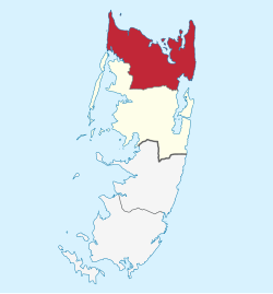 Location in Pemba North | |
| Coordinates: 4°59′2.4″S 39°45′18″E / 4.984000°S 39.75500°E / -4.984000; 39.75500 | |
| Country |  Tanzania Tanzania |
| Region | Pemba South Region |
| Capital | Konde |
| Area | |
| • Total | 231 km2 (89 sq mi) |
| • Rank | 2nd in Pemba North |
| Population (2022) | |
| • Total | 123,379 |
| • Rank | 2nd in Pemba North |
| • Density | 530/km2 (1,400/sq mi) |
| Demonym | Michewenian |
| Ethnic groups | |
| • Settler | Swahili |
| • Native | Hadimu |
Micheweni District (Wilaya ya Micheweni in Swahili) is one of two administrative districts of Pemba North Region in Tanzania.[1] The district covers an area of 231.1 km2 (89.2 sq mi).[2] The district is comparable in size to the land area of Cook Islands.[3] The district has a water border to the east, north and west by the Indian Ocean. The district is bordered to the south by Wete District. The district seat (capital) is the town of Konde. According to the 2022 census, the district has a total population of 123,379.[4][5]
Administrative subdivisions
Constituencies
For parliamentary elections, Tanzania is divided into constituencies. As of the 2010 elections Micheweni District had four constituencies:[6]
- Konde Constituency
- Mgogoni Constituency
- Micheweni Constituency
- Tumbe Constituency
Divisions
Wards
Micheweni District is administratively divided into ten wards:[7]
|
|
Education
In the 2002 census literacy in Micheweni District stood at 40 percent for those aged 5 years and above. Literacy in Swahili was 30 percent, while 19 percent were literate in English, with 9 percent overlap.[9]
References
- ^ "Micheweni District".
- ^ "Micheweni District Profile" (PDF). Government of Zanzibar. 2019. Retrieved 23 July 2022.
- ^ 236.7 km2 (91.4 sq mi) for Cook Islands at "Area size comparison". Nation master. 2022. Retrieved 23 July 2022.
- ^ "Micheweni (District, Tanzania) - Population Statistics, Charts, Map and Location". www.citypopulation.de. Retrieved 2024-02-10.
- ^ "2012 Population and Housing Census General Report" (PDF). Government of Tanzania. Retrieved 2022-06-10.
- ^ "Organisations located in Micheweni District - Tanzania". African Development Information.
- ^ "Postcodes Kaskazini Pemba Region 75000" (PDF). 2012. Archived from the original (PDF) on 2012-09-02. Retrieved 2012-09-02.
- ^ Micheweni (Approved) at GEOnet Names Server, United States National Geospatial-Intelligence Agency
- ^ "2002 Population and Housing Census, Volume IV, District Profile Micheweni" (PDF). Central Census Office, National Bureau of Statistics, President's Office, Planning and Privatization, United Republic of Tanzania. 2004. Archived from the original (pdf) on 2012-09-02.
- v
- t
- e
Micheweni District
Capital: Konde
- Kinowe
- Kiuyu Maziwa Ng'ombe
- Konde
- Mgogoni
- Micheweni
- Msuka
- Shumba Viamboni
- Tumbe
- Wingwi Mapofu
- Wingwi Njuguni
- Tumbe
- Magogoni
- Ngezi Forest Reserve
- Msitu Kuu Forest Reserve
Authority control databases | |
|---|---|
| International |
|
| National |
|
 | This Pemba North Region location article is a stub. You can help Wikipedia by expanding it. |
- v
- t
- e


