Markelfinger Winkel
47°44′17″N 08°59′40″E / 47.73806°N 8.99444°E / 47.73806; 8.99444Primary inflows Östlicher Sibach Primary outflows Gnadensee Max. length 1.44 kilometres (0.89 mi) Max. width 0.98 kilometres (0.61 mi) Surface area 1.06 kilometres (0.66 mi)2 Shore length1 4 kilometres (2.5 mi) 1 Shore length is not a well-defined measure. 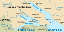
Settlements


Islands Rivers Mountains Landmarks
Transportation Films People
The Markelfinger Winkel is the part of Lake Constance between the upper part of the Mettnau Peninsula and Markelfingen. It is the northwestern continuation of the Gnadensee and its parent lake, the Untersee ("Lower Lake Constance"). It has an area of around one square kilometre.[1]
References
- ^ Bodensee: Teilseen und Rheinmündung Archived 2015-02-18 at the Wayback Machine (map)

- v
- t
- e
Lake Constance (Bodensee)
- Austria
- Vorarlberg
- Bregenz
- Vorarlberg
- Germany
- Baden-Württemberg
- Bodenseekreis
- Konstanz
- Bavaria
- Lindau
- Baden-Württemberg
- Switzerland
- Appenzell Ausserrhoden
- Schaffhausen
- St. Gallen
- Rorschach
- Thurgau
- Arbon
- Frauenfeld
- Kreuzlingen
| Austria | |
|---|---|
| Germany |
|
| Switzerland |
|


- Bodanrück Peninsula
- Dominicans Island
- Entlibühl
- Galgeninsel
- Hoy
- Liebesinsel
- Lindau
- Mainau
- Mettnau Peninsula
- Reichenau
- Triboldingerbohl
- Vogelinsel
- Werd
- Obersee
- Bay of Bregenz
- Constance Hopper
- Überlinger See
- Rhine Delta
- Untersee
- Gnadensee
- Markelfinger Winkel
- Rheinsee
- Wollmatinger Ried
- Zeller See
| Buildings |
|
|---|---|
| Touristic |
 | This Konstanz location article is a stub. You can help Wikipedia by expanding it. |
- v
- t
- e


