Lurnfeld
You can help expand this article with text translated from the corresponding article in German. (September 2012) Click [show] for important translation instructions.
- View a machine-translated version of the German article.
- Machine translation, like DeepL or Google Translate, is a useful starting point for translations, but translators must revise errors as necessary and confirm that the translation is accurate, rather than simply copy-pasting machine-translated text into the English Wikipedia.
- Consider adding a topic to this template: there are already 9,128 articles in the main category, and specifying
|topic=will aid in categorization. - Do not translate text that appears unreliable or low-quality. If possible, verify the text with references provided in the foreign-language article.
- You must provide copyright attribution in the edit summary accompanying your translation by providing an interlanguage link to the source of your translation. A model attribution edit summary is
Content in this edit is translated from the existing German Wikipedia article at [[:de:Lurnfeld]]; see its history for attribution. - You may also add the template
{{Translated|de|Lurnfeld}}to the talk page. - For more guidance, see Wikipedia:Translation.
Place in Carinthia, Austria

Coat of arms
(2018-01-01)[2]
9813
Lurnfeld is a market town in the district of Spittal an der Drau in the Austrian state of Carinthia. The municipality consists of the two Katastralgemeinden: Möllbrücke and Pusarnitz, comprising several small villages.
It is located within the eponymous valley of the Drava river, on the southern slope of the Ankogel Group of the Hohe Tauern range, west of the district's capital Spittal an der Drau. At Möllbrücke is the confluence of the Drava with the Möll tributary. In the west the valley is confined by the mountains of the Kreuzeck group and in the south by the Gailtal Alps.
History
The Lurnfeld valley around the Roman city of Teurnia is a very old settlement area, in ancient times called vallis Lurna. In an 891 deed mentioned as Liburnia, it became the centre of the Upper Carinthian counts in the mediæval Lurngau, who resided at Hohenburg Castle. Their dominions then stretched from west of Villach up the Drava to Lienz and the Tyrolean border.
Pusarnitz already appeared in a 1072 deed. After the Counts of Lurn became extinct in 1135, it was among the Carinthian possessions of the Salzburg archbishops. The remaining estates were inherited by the Counts of Ortenburg, while the Tyrolean Meinhardiner dynasty, Counts of Görz since 1127, expanded their possessions in the west. The main village Möllbrücke was first mentioned as mölnprukke in 1253. In 1307 it was denoted as a possession of the Meinhardiner counts of Görz and seat of a county court.
When the Carinthian counts of Ortenburg became extinct in 1418, their estates were bequested to the Counts of Celje. Count Ulrich II was even elevated to a Prince of the Holy Roman Empire by the Emperor Sigismund, but left no heirs when he was killed by his bitter rival Ladislaus Hunyadi in 1456. He had signed an inheritance treaty with the Habsburg emperor Frederick III, also Duke of Carinthia since 1424. However, the Meinhardiner count John II of Görz also claimed the former Ortenburg dominions. He marched against Carinthia from his Tyrolean residence at Bruck Castle, crossing the border at Oberdrauburg and occupying Spittal to lay siege to the Ortenburg fortress. He was finally defeated in 1460 and had to sign the Treaty of Pusarnitz at episcopal Feldsberg Castle, whereby he renounced all Carinthian estates in favour of the Austrian House of Habsburg.
Politics
The Lurnfeld municipality was created by the merger of Möllbrücke, Pusarnitz and neighbouring Sachsenburg in 1973; the citizens of Sachsenburg decided to split off again in 1992.
Seats in the municipal assembly (Gemeinderat) as of 2009 elections:
- Freedom Party in Carinthia (FPK): 10
- Social Democratic Party of Austria (SPÖ): 6
- Austrian People's Party (ÖVP): 2
- Greens: 1
Gallery
-
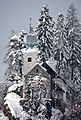 St Maria in Hohenburg pilgrimage church
 -
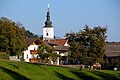
 Moellbruecke with "Hoher Stand" mountain in the background
 -
 Pusarnitz in the community of Lurnfeld
 -
 Möllbrücke, church: Pfarrkirche Sankt Leonhard
 -
 Roman milestone near Moellbruecke
 -
 Ruin of Feldsberg castle
 -
 Drauhofen castle


References
Wikimedia Commons has media related to Lurnfeld.
- v
- t
- e
Municipalities in the district of Spittal an der Drau
- Bad Kleinkirchheim
- Baldramsdorf
- Berg im Drautal
- Dellach im Drautal
- Flattach
- Gmünd
- Greifenburg
- Großkirchheim
- Heiligenblut
- Irschen
- Kleblach-Lind
- Krems
- Lendorf
- Lurnfeld
- Mallnitz
- Malta
- Millstatt
- Mörtschach
- Mühldorf
- Oberdrauburg
- Obervellach
- Radenthein
- Rangersdorf
- Reißeck
- Rennweg am Katschberg
- Sachsenburg
- Seeboden
- Spittal an der Drau
- Stall
- Steinfeld
- Trebesing
- Weissensee
- Winklern

Authority control databases | |
|---|---|
| International |
|
| National |
|


