Llanos Basin

05°24′00″N 71°40′00″W / 5.40000°N 71.66667°W / 5.40000; -71.66667EtymologyLlanos Orientales
Spanish: "eastern plains"RegionOrinoquíaCountry ColombiaState(s)Arauca, Boyacá, Casanare, Cundinamarca, Guainía, Guaviare, Meta, Norte de SantanderCitiesVillavicencio, YopalCharacteristicsOn/OffshoreOnshoreBoundariesColombia-Venezuela border (N), Guiana Shield (E), Vaupés Arch (S), Serranía de la Macarena (SW), Eastern Ranges (W)Part ofAndean foreland basinsArea96,000 km2 (37,000 sq mi)HydrologyRiver(s)Orinoco watershed
Main rivers: Arauca, Meta, Guaviare, VichadaGeologyBasin typeForeland on rift basin[note 1]PlateSouth American[note 3]OrogenyBreak-up of Pangea (Mesozoic)
Andean (Cenozoic)AgePaleozoic or Jurassic[note 2]
to HoloceneStratigraphyStratigraphyFaultsEastern (W, bounding), Chichimene & MetaField(s)Rubiales, Caño Limón, many more

The Llanos Basin (Spanish: Cuenca Llanos) or Eastern Llanos Basin (Spanish: Cuenca de los Llanos Orientales) is a major sedimentary basin of 96,000 square kilometres (37,000 sq mi) in northeastern Colombia. The onshore foreland on Mesozoic rift basin covers the departments of Arauca, Casanare and Meta and parts of eastern Boyacá and Cundinamarca, western Guainía, northern Guaviare and southeasternmost Norte de Santander. The northern boundary is formed by the border with Venezuela, where the basin grades into the Barinas-Apure Basin.

Description

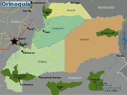
The northeastern part of Colombia is characterized by its wavy plains, called Llanos Orientales, as part of the bigger Llanos that extend into Venezuela. The landscape is similar to a savanna and is poor in trees. It is located between the Eastern Ranges of the Colombian Andes in the west, the Vaupés Arch in the south and the Guiana Shield in the east.[1]

Geologically, the Llanos Basin underlies this typical landscape of the Llanos. An area where transport occurs mostly by small boats along the many rivers and the "buses of the Llanos", the Douglas DC-3 planes. The basin covers an area of 96,000 square kilometres (37,000 sq mi) and contains a stratigraphic column from the Paleozoic to recent.[2] Several of the formations in the basins are source rocks (Gachetá, Los Cuervos, Carbonera C8), reservoir rocks (Mirador, Barco, Guadalupe and the uneven numbered members of Carbonera). Seals are formed by the shaly intervals (even numbered) of the Carbonera Formation, Los Cuervos, and León.[3]

The basin is the main petroleum producing basin of Colombia, with four of the nations biggest oil fields located in the Llanos Basin. Major fields are Rubiales, Colombia's biggest and most recent giant discovery sealed by a complex of hydrodynamic processes, and Caño Limón, at the border with Venezuela.

Major concerns in the basin for the production of petroleum are biodegradation, hydrocarbon migration, fault seal capacity and water flow.

Hydrography

Rivers of the Llanos Basin
Ariarí River

The Llanos Basin is crossed by numerous rivers, all belonging to the Orinoco watershed. From north to south:

Flora and fauna

Fauna

Map of national parks in Orinoquía region

Among other species, Lynch's swamp frog (Pseudopaludicola llanera) is endemic to the Llanos, with the species epithet referring to the plains.[4] Also the whip scorpion Mastigoproctus colombianus is reported from the Llanos Basin.[5]

Geodynamic situation

Plate tectonic situation of northwestern South America.
Nazca Plate has been subdivided into Coiba and Malpelo Plates
Coiba & Malpelo Plates

The country of Colombia spreads out over six tectonic plates, clockwise from north:

  1. Caribbean Plate
  2. North Andes Plate
  3. South American Plate
  4. Malpelo Plate
  5. Coiba Plate
  6. Panama Plate

The Llanos Basin is situated entirely on the South American Plate, bordering the North Andean Block or North Andean microplate in the west. The basin is one of three Colombian basins on the South American Plate, to the south the Caguán-Putumayo Basin and to the southeast the Vaupés-Amazonas Basin. The northern boundary of the Llanos Basin is formed by the Colombia-Venezuela border where the basin grades into the Barinas-Apure Basin on the Venezuelan side. The Catatumbo Basin, representing the Colombian portion of the larger Maracaibo Basin borders the Llanos Basin in the northwest and the western boundary is formed by the foothills (Piedemonte) of the Eastern Cordillera Basin, the sedimentary basin covering the Eastern Ranges of the Colombian Andes.

Tectonics

The basin is bound to the west by the Eastern Frontal Fault System, a 921.4 kilometres (572.5 mi) long fault system connecting the North Andes and South American Plates and thus the Eastern Cordillera Basin and the Llanos Basin. The fault system has an average strike of 042.1±19, but this orientation varies greatly along its course. The 1827, 1834, 1917, 1967, 1995, and 2008 earthquakes were all caused by fault movement as part of the system.[6]

Basin history

The tectonic history of the Llanos Basin, a foreland basin formed on top of Mesozoic rift basins, Paleozoic metasediments and Precambrian basement underlain by continental crust, goes back to the Early Jurassic.

The Andean orogeny, represented by the tectonic uplift of the Colombian Eastern Ranges and its northern extension, the Serranía del Perijá, caused tilting and uplift in the Llanos Basin. During the Andean orogenic phase, the paleotemperatures in the basin dropped considerably; in the Baja Guajira area from 115 °C (239 °F) in the Early Miocene to 70 °C (158 °F) in the Late Miocene.[7] In the Late Miocene to Pliocene, the major faults to the southwest of the Cocinetas Basin, the Oca and Bucaramanga-Santa Marta Faults were tectonically active.[8]

Basement

The Cerros de Mavecure in Guainía are a remnant of the Proterozoic basement underlying the Llanos Basin
The Serranía de Chiribiquete in Guaviare

The stratigraphy of the Llanos Basin ranges, depending on the definition from either Jurassic or Paleozoic to recent. The basement is formed by the westernmost extensions of the Guiana Shield. Remnants of these Precambrian formations are found as inselbergs in the far east of Colombia (Cerros de Mavecure), in the Serranía de la Macarena to the southwest of the basin and in the tepuis of the Serranía de Chiribiquete to the southeast.

The Proterozoic crystalline rocks are overlain by metamorphosed sedimentary and igneous rocks ranging in age from Cambrian to Devonian. Younger and contemporaneous Paleozoic deposits are only found in the subsurface and in regional correlative units as the Floresta and Cuche Formations of the Altiplano Cundiboyacense to the direct northwest and the Río Cachirí Group of the Cesar-Ranchería Basin farther northwest of the Llanos Basin.

The units found in the Llanos Basin pertain to the Farallones Group and comprise the Valle del Guatiquía Red Beds, Pipiral Shale and the Gutiérrez Sandstone.[9]

Stratigraphy

Stratigraphy of the Llanos Basin and surrounding provinces
Ma Age Paleomap Regional events Catatumbo Cordillera proximal Llanos distal Llanos Putumayo VSM Environments Maximum thickness Petroleum geology Notes
0.01 Holocene
Holocene volcanism
Seismic activity
alluvium Overburden
1 Pleistocene
Pleistocene volcanism
Andean orogeny 3
Glaciations
Guayabo Soatá
Sabana
Necesidad Guayabo Gigante
Neiva
Alluvial to fluvial (Guayabo) 550 m (1,800 ft)
(Guayabo)
[10][11][12][13]
2.6 Pliocene
Pliocene volcanism
Andean orogeny 3
GABI
Subachoque
5.3 Messinian Andean orogeny 3
Foreland
Marichuela Caimán Honda [12][14]
13.5 Langhian Regional flooding León hiatus Caja León Lacustrine (León) 400 m (1,300 ft)
(León)
Seal [13][15]
16.2 Burdigalian Miocene inundations
Andean orogeny 2
C1 Carbonera C1 Ospina Proximal fluvio-deltaic (C1) 850 m (2,790 ft)
(Carbonera)
Reservoir [14][13]
17.3 C2 Carbonera C2 Distal lacustrine-deltaic (C2) Seal
19 C3 Carbonera C3 Proximal fluvio-deltaic (C3) Reservoir
21 Early Miocene Pebas wetlands C4 Carbonera C4 Barzalosa Distal fluvio-deltaic (C4) Seal
23 Late Oligocene
Andean orogeny 1
Foredeep
C5 Carbonera C5 Orito Proximal fluvio-deltaic (C5) Reservoir [11][14]
25 C6 Carbonera C6 Distal fluvio-lacustrine (C6) Seal
28 Early Oligocene C7 C7 Pepino Gualanday Proximal deltaic-marine (C7) Reservoir [11][14][16]
32 Oligo-Eocene C8 Usme C8 onlap Marine-deltaic (C8) Seal
Source
[16]
35 Late Eocene
Mirador Mirador Coastal (Mirador) 240 m (790 ft)
(Mirador)
Reservoir [13][17]
40 Middle Eocene Regadera hiatus
45
50 Early Eocene
Socha Los Cuervos Deltaic (Los Cuervos) 260 m (850 ft)
(Los Cuervos)
Seal
Source
[13][17]
55 Late Paleocene PETM
2000 ppm CO2
Los Cuervos Bogotá Gualanday
60 Early Paleocene SALMA Barco Guaduas Barco Rumiyaco Fluvial (Barco) 225 m (738 ft)
(Barco)
Reservoir [10][11][14][13][18]
65 Maastrichtian
KT extinction Catatumbo Guadalupe Monserrate Deltaic-fluvial (Guadalupe) 750 m (2,460 ft)
(Guadalupe)
Reservoir [10][13]
72 Campanian End of rifting Colón-Mito Juan [13][19]
83 Santonian Villeta/Güagüaquí
86 Coniacian
89 Turonian Cenomanian-Turonian anoxic event La Luna Chipaque Gachetá hiatus Restricted marine (all) 500 m (1,600 ft)
(Gachetá)
Source [10][13][20]
93 Cenomanian
Rift 2
100 Albian Une Une Caballos Deltaic (Une) 500 m (1,600 ft)
(Une)
Reservoir [14][20]
113 Aptian
Capacho Fómeque Motema Yaví Open marine (Fómeque) 800 m (2,600 ft)
(Fómeque)
Source (Fóm) [11][13][21]
125 Barremian High biodiversity Aguardiente Paja Shallow to open marine (Paja) 940 m (3,080 ft)
(Paja)
Reservoir [10]
129 Hauterivian
Rift 1 Tibú-
Mercedes
Las Juntas hiatus Deltaic (Las Juntas) 910 m (2,990 ft)
(Las Juntas)
Reservoir (LJun) [10]
133 Valanginian Río Negro Cáqueza
Macanal
Rosablanca
Restricted marine (Macanal) 2,935 m (9,629 ft)
(Macanal)
Source (Mac) [11][22]
140 Berriasian Girón
145 Tithonian Break-up of Pangea Jordán Arcabuco Buenavista
Batá
Saldaña Alluvial, fluvial (Buenavista) 110 m (360 ft)
(Buenavista)
"Jurassic" [14][23]
150 Early-Mid Jurassic
Passive margin 2 La Quinta
Montebel

Noreán
hiatus Coastal tuff (La Quinta) 100 m (330 ft)
(La Quinta)
[24]
201 Late Triassic
Mucuchachi Payandé [14]
235 Early Triassic
Pangea hiatus "Paleozoic"
250 Permian
300 Late Carboniferous
Famatinian orogeny Cerro Neiva
()
[25]
340 Early Carboniferous Fossil fish
Romer's gap
Cuche
(355-385)
Farallones
()
Deltaic, estuarine (Cuche) 900 m (3,000 ft)
(Cuche)
360 Late Devonian
Passive margin 1 Río Cachirí
(360-419)
Ambicá
()
Alluvial-fluvial-reef (Farallones) 2,400 m (7,900 ft)
(Farallones)
[22][26][27][28][29]
390 Early Devonian
High biodiversity Floresta
(387-400)
El Tíbet
Shallow marine (Floresta) 600 m (2,000 ft)
(Floresta)
410 Late Silurian Silurian mystery
425 Early Silurian hiatus
440 Late Ordovician
Rich fauna in Bolivia San Pedro
(450-490)
Duda
()
470 Early Ordovician First fossils Busbanzá
(>470±22)
Chuscales
Otengá
Guape
()
Río Nevado
()
Hígado
()
Agua Blanca
Venado
(470-475)
[30][31][32]
488 Late Cambrian
Regional intrusions Chicamocha
(490-515)
Quetame
()
Ariarí
()
SJ del Guaviare
(490-590)
San Isidro
()
[33][34]
515 Early Cambrian Cambrian explosion [32][35]
542 Ediacaran
Break-up of Rodinia pre-Quetame post-Parguaza El Barro
()
Yellow: allochthonous basement
(Chibcha Terrane)
Green: autochthonous basement
(Río Negro-Juruena Province)
Basement [36][37]
600 Neoproterozoic Cariri Velhos orogeny Bucaramanga
(600-1400)
pre-Guaviare [33]
800
Snowball Earth [38]
1000 Mesoproterozoic
Sunsás orogeny Ariarí
(1000)
La Urraca
(1030-1100)
[39][40][41][42]
1300 Rondônia-Juruá orogeny pre-Ariarí Parguaza
(1300-1400)
Garzón
(1180-1550)
[43]
1400
pre-Bucaramanga [44]
1600 Paleoproterozoic Maimachi
(1500-1700)
pre-Garzón [45]
1800
Tapajós orogeny Mitú
(1800)
[43][45]
1950 Transamazonic orogeny pre-Mitú [43]
2200 Columbia
2530 Archean
Carajas-Imataca orogeny [43]
3100 Kenorland
Sources
Legend
  • group
  • important formation
  • fossiliferous formation
  • minor formation
  • (age in Ma)
  • proximal Llanos (Medina)[note 4]
  • distal Llanos (Saltarin 1A well)[note 5]


Paleozoic

Cambro-Ordovician
  • Guape Formation
  • Duda Formation
  • Ariarí Formation
  • Ariarí Metagabbro
Pre-Devonian
  • Quetame Group
    • Río Guamal Metasiltstones
    • Guayabetal Phyllites and Quartzites
    • San Cristóbal Quartzites and Phyllites
    • Susumuco Metaconglomerates and Phyllites
Devonian
  • Farallones Group
    • Valle del Guatiquía Red Beds
    • Pipiral Shale
    • Gutiérrez Sandstone

Jurassic

  • Buenavista Breccia

Petroleum geology

The Llanos Basin is the most prolific hydrocarbon basin of Colombia, hosting well-known petroleum deposits as Caño Limón, Rubiales and other fields. Nine of the twenty most producing oil fields of Colombia are situated in the Llanos Basin.

Fields

Based on data released in March 2018, Colombia is the 21st oil producer in the world. Daily production dropped in 2017 to 854.121 thousand barrels per day (135.7944×10^3 m3/d).[50] In 2016, twenty oilfields produced 66% of all oil of Colombia, listed below in bold.[51] The total proven reserves of Colombia were 1,665.489 million barrels (264.7916×10^6 m3) in 2016.[52]

Major oil fields in the Llanos Basin are:[53]

Major oil and gas fields of the Llanos Basin
Name Map Location Operator Reservoirs Reserves
Production (2016)
Notes
Rubiales
Puerto Gaitán
Meta
Ecopetrol Carbonera 7 4,380 million bbl (696 million m3)
132.000 kbbl/d (20.9863×10^3 m3/d)
Castilla
Castilla la Nueva
Meta
Ecopetrol Mirador
Gachetá
Une
452 million bbl (71.9 million m3)
121.363 kbbl/d (19.2952×10^3 m3/d)
[54][55]
Chichimene
Acacias
Meta
Ecopetrol Mirador
Guadalupe
Gachetá
Une
74.052 kbbl/d (11.7733×10^3 m3/d) [56][57]
Quifa
Puerto Gaitán
Meta
Meta Petroleum Carbonera 613 million bbl (97.5 million m3)
46.557 kbbl/d (7.4020×10^3 m3/d)
[58][59]
Caño Limón
Puerto Rondón
Arauca
Ecopetrol 20.930 kbbl/d (3.3276×10^3 m3/d) [60]
Avispa
Cabuyaro
Meta
Pacific Rubiales 11.625 kbbl/d (1.8482×10^3 m3/d)
Ocelote
Puerto Gaitán
Meta
Hocol 11.228 kbbl/d (1.7851×10^3 m3/d)
Chipirón
Puerto Rondón
Arauca
OXY 10.459 kbbl/d (1.6628×10^3 m3/d) [59]
Jacana
Villanueva
Casanare
Geopark 7.477 kbbl/d (1.1887×10^3 m3/d)
Cupiagua
Aguazul
Casanare
Ecopetrol 5.358 kbbl/d (851.9 m3/d)
Apiay
Villavicencio
Meta
Ecopetrol Gachetá
Une
Arauca
Arauca
Arauca
Ecopetrol
Cusiana
Tauramena
Casanare
Ecopetrol Mirador
Barco
Guadalupe
  • Other fields[53]
    • Caño Verde
    • Chaparrito
    • Concesión
    • Corcel
    • Cravo Sur
    • La Gloria
    • Santiago
    • Trinidad
    • Valdivia

Mining

Mining activities in the Llanos Basin are restricted to certain areas, resulting in less conflicts, more common with indigenous peoples in the Amazonian part of Colombia.[61]

In San José del Guaviare platinum is mined.[65]

Mining in the Llanos Basin and surrounding areas
Resources Map Department Municipality Mine Notes
halite
Meta Restrepo Upín [63][66]
gold
Puerto Rico [62]
Arauca Arauca
gold
Guaviare San José del Guaviare
platinum, iron, albite, andradite (var: melanite), 'apatite', arfvedsonite, 'biotite', calcite, cancrinite, epidote, fluorite, 'garnet', microcline, 'monazite', nepheline, siderite, titanite, zircon [65][67]
coal
Casanare Recetor [64]

Paleontology

Llanos Basin is located in Colombia
B
B
C
C
F
F
L
L
J
J
M
M
P
P
H
H
Co
Co
class=notpageimage|
Major fossiliferous formations
Neogene
 H = Honda Group
 Co = Cocinetas Basin
Paleogene
 B = Bogotá
 C = Cerrejón
Cretaceous
 L = La Frontera
 P = Paja
Jurassic
 J = Valle Alto
Devonian
 F = Cuche and Floresta
Cambro-Ordovician
 M = Duda, La Macarena

Compared to many fossiliferous formations in Colombia, the Llanos Basin has been lean in fossil content. Most of the basin stratigraphy is only known from wells.

Paleozoic outcrops surrounding and perforating the planar geography have provided fossils dating back to the Cambrian; the Duda and Ariarí Formations.

Several fossiliferous formations of contemporaneous depositional environments have provided many unique fossils indicative of paleoclimatic conditions; turtle fossils were described from Los Cuervos in the Cesar-Ranchería Basin, and the Mirador Formation in the Catatumbo Basin direct northwest of the Llanos Basin has provided many fossil flora.[68]

Other correlative units with surrounding basins

See also

Sources

Notes

  1. ^ More detailed: continental margin (Protero- and Paleozoic), rift basin (Mesozoic), foredeep (Paleogene and early Neogene), foreland (late Neogene to recent)
  2. ^ Depending on the definition of basement, the stratigraphic succession starts either in the Paleozoic on Proterozoic crystalline basement or Jurassic on top of both
  3. ^ The northernmost of three Colombian basins on this plate, to the south the Caguán-Putumayo and Vaupés-Amazonas Basins
  4. ^ based on Duarte et al. (2019)[46], García González et al. (2009),[47] and geological report of Villavicencio[48]
  5. ^ based on Duarte et al. (2019)[46] and the hydrocarbon potential evaluation performed by the UIS and ANH in 2009[49]

References

  1. ^ Barrero et al., 2007, p.69
  2. ^ ANH, 2010
  3. ^ García González et al., 2009, p.58
  4. ^ Pseudopaludicola llanera at IUCN.org
  5. ^ Mastigoproctus colombianus at GBIF.org
  6. ^ Paris et al., 2000a, p.36
  7. ^ Hernández Pardo et al., 2009, p.122
  8. ^ Hernández Pardo et al., 2009, p.28
  9. ^ Plancha 266, 1998
  10. ^ a b c d e f García González et al., 2009, p.27
  11. ^ a b c d e f García González et al., 2009, p.50
  12. ^ a b García González et al., 2009, p.85
  13. ^ a b c d e f g h i j Barrero et al., 2007, p.60
  14. ^ a b c d e f g h Barrero et al., 2007, p.58
  15. ^ Plancha 111, 2001, p.29
  16. ^ a b Plancha 177, 2015, p.39
  17. ^ a b Plancha 111, 2001, p.26
  18. ^ Plancha 111, 2001, p.24
  19. ^ Plancha 111, 2001, p.23
  20. ^ a b Pulido & Gómez, 2001, p.32
  21. ^ Pulido & Gómez, 2001, p.30
  22. ^ a b Pulido & Gómez, 2001, pp.21-26
  23. ^ Pulido & Gómez, 2001, p.28
  24. ^ Correa Martínez et al., 2019, p.49
  25. ^ Plancha 303, 2002, p.27
  26. ^ Terraza et al., 2008, p.22
  27. ^ Plancha 229, 2015, pp.46-55
  28. ^ Plancha 303, 2002, p.26
  29. ^ Moreno Sánchez et al., 2009, p.53
  30. ^ Mantilla Figueroa et al., 2015, p.43
  31. ^ Manosalva Sánchez et al., 2017, p.84
  32. ^ a b Plancha 303, 2002, p.24
  33. ^ a b Mantilla Figueroa et al., 2015, p.42
  34. ^ Arango Mejía et al., 2012, p.25
  35. ^ Plancha 350, 2011, p.49
  36. ^ Pulido & Gómez, 2001, pp.17-21
  37. ^ Plancha 111, 2001, p.13
  38. ^ Plancha 303, 2002, p.23
  39. ^ Plancha 348, 2015, p.38
  40. ^ Planchas 367-414, 2003, p.35
  41. ^ Toro Toro et al., 2014, p.22
  42. ^ Plancha 303, 2002, p.21
  43. ^ a b c d Bonilla et al., 2016, p.19
  44. ^ Gómez Tapias et al., 2015, p.209
  45. ^ a b Bonilla et al., 2016, p.22
  46. ^ a b Duarte et al., 2019
  47. ^ García González et al., 2009
  48. ^ Pulido & Gómez, 2001
  49. ^ García González et al., 2009, p.60
  50. ^ Producción de crudo bajó en 30.879 barriles por día en 2017 - El Tiempo
  51. ^ En 20 campos se produce el 66 % del petróleo del país - El Tiempo
  52. ^ Oil reserves per department - 2016 - ANH
  53. ^ a b Mojica et al., 2009, p.30
  54. ^ ANH & Halliburton, s.a., p.2
  55. ^ Castilla, área petrolera especial - El Tiempo
  56. ^ ANH & Halliburton, s.a., p.3
  57. ^ Chichimene
  58. ^ Las reservas de campo Quifa se reducen en 5,9 millones de barriles
  59. ^ a b Mapa de Tierras, ANH, 2017
  60. ^ Caño Limón
  61. ^ (in Spanish) Mapa de Territorios Indígenas y Minerales Preciosos
  62. ^ a b (in Spanish) Producción de oro – UPME
  63. ^ a b (in Spanish) Producción de sal – UPME
  64. ^ a b (in Spanish) Producción de carbón – UPME
  65. ^ a b (in Spanish) Producción de platino – UPME
  66. ^ Upin at Mindat.org
  67. ^ San José del Guaviare at Mindat.org
  68. ^ Jaramillo & Dilcher, 2001

Bibliography

General

  • Barrero, Dario; Andrés Pardo; Carlos A. Vargas, and Juan F. Martínez. 2007. Colombian Sedimentary Basins: Nomenclature, Boundaries and Petroleum Geology, a New Proposal, 1–92. ANH.
  • García González, Mario; Ricardo Mier Umaña; Luis Enrique Cruz Guevara, and Mauricio Vásquez. 2009. Informe Ejecutivo - evaluación del potencial hidrocarburífero de las cuencas colombianas, 1-219. Universidad Industrial de Santander.

Hydrodynamics

  • Mora, Andrés; Ricardo Andrés Gómez; Camilo Díaz; Victor Caballero; Mauricio Parra; Carlos Villamizar; Álvaro Lasso; Richard A. Ketcham, and Felipe González Penagos, John Rico and Juan Pablo Arias Martínez. 2019. Water flow, oil biodegradation, and hydrodynamic traps in the Llanos Basin, Colombia. AAPG Bulletin 103. 1225-1264. Accessed 2019-10-26.
  • Duarte, Edward; German Bayona; Carlos Jaramillo; Mauricio Parra; Ingrid Romero, and Josué Alejandro Mora. 2017. Identificación de los máximos eventos de inundación marina Miocenos y su uso en la correlación y análisis de la cuenca de antepaís de los Llanos Orientales, Colombia. Boletín de Geología 39. 19-40. Accessed 2019-10-26.
  • Bartha, Attila; Nelly De Nicolais; Vinod Sharma; S.K. Roy; Rajiv Srivastava; Andrew E. Pomerantz; Milton Sanclemente; Wilmar Pérez, and Robert K. Nelson, Christopher M. Reddy, Jonas Gros, J. Samuel Arey, Jaron Lelijveld, Sharad Dubey, Diego Tortella, Thomas Hantschel, Kenneth E. Peters and Oliver C. Mullins. 2015. Combined Petroleum System Modeling and Comprehensive Two-Dimensional Gas Chromatography To Improve Understanding of the Crude Oil Chemistry in the Llanos Basin, Colombia. Energy & Fuels, American Chemical Society 29. 4755-4767. Accessed 2019-10-26.
  • Gómez Galarza, Yohaney; Franklin Yoris; Javier Rodríguez; Fredy Portillo, and Ysidro Araujo. 2010. Aspectos hidrodinámicos, estructurales y estratigráficos del Campo Rubiales. Geo Petróleo 9. 1-28. Accessed 2017-06-07.
  • Gómez, A.; C. Jaramillo; M. Parra, and A. Mora. 2009. Huesser Horizon: A lake and marine incursion in Northwestern South America during the Early Miocene. PALAIOS 24. 199-210. Accessed 2019-10-26.

Tectonics

  • Paris, Gabriel; Michael N. Machette; Richard L. Dart, and Kathleen M. Haller. 2000a. Map and Database of Quaternary Faults and Folds in Colombia and its Offshore Regions, 1–66. USGS. Accessed 2017-09-18.
  • Paris, Gabriel; Michael N. Machette; Richard L. Dart, and Kathleen M. Haller. 2000b. Map of Quaternary Faults and Folds of Colombia and Its Offshore Regions, 1. USGS. Accessed 2017-09-18.

Petroleum

  • Martínez Sánchez, Dilan, and Giovanny Jiménez. 2019. Hydraulic fracturing considerations: Insights from analogue models, and its viability in Colombia. Earth Sciences Research Journal 23. 5-15. Accessed 2019-10-26. ISSN 1794-6190
  • Vargas Jiménez, Carlos A. 2012. Evaluating total Yet-to-Find hydrocarbon volume in Colombia. Earth Sciences Research Journal 16. 1–290. Accessed 2017-06-14.
  • Mojica, Jairo; Oscar J. Arévalo, and Hardany Castillo. 2009. Cuencas Catatumbo, Cesar – Ranchería, Cordillera Oriental, Llanos Orientales, Valle Medio y Superior del Magdalena, 1–65. ANH. Accessed 2017-06-14.
  • Piedrahita, Carlos, and Clara L. Montaña. 2007. Methodology implemented for the 3D-Seismic modelling using GoCad and NORSAR 3D Software applied to complex areas in the Llanos foothills. Earth Sciences Research Journal 11. 35-43. Accessed 2019-10-26.
  • Hernández Pardo, Orlando; Ralph R.B. von Frese, and Jeong Woo Kim. 2007. Crustal thickness variations and seismicity of northwestern South America. Earth Sciences Research Journal 11. 81-94. Accessed 2019-10-26.
  • N., N. 2006. Cuenca Llanos Orientales - Estudio Integrado - Crudos Pesados, 1-10. ANH. Accessed 2017-06-07.

Paleontology

  • Jaramillo, Carlos A., and D.L. Dilcher. 2001. Middle Paleogene palynology of Central Colombia, South America: A study of pollen and spores from tropical latitudes. Palaeontographica Abteilung B 258. 87-213. Accessed 2019-10-26.

Reports

  • Pinto Valderrama, Jorge Eduardo; José Pedro Mora Ortiz; Gloria Reátiga Tarazona; Jorge Alberto Rey Pilonieta; Silvia Johana Toloza Hormiga; Diego Andrés Torres Coronado; David Ricardo Vargas Mojica, and Cristian Julián Zafra Manrique. 2010. Geología del Piedemonte Llanero en la Cordillera Oriental, departamentos de Arauca y Casanare, 1-64. INGEOMINAS & Universidad Industrial de Santander. Accessed 2017-08-04.
  • Terraza, Roberto; Diana Montoya; Germán Reyes; Giovanni Moreno; Jaime Fúquen; Eliana Torres Jaimes; Myriam López Cardona; Álvaro Nivia Guevara, and Fernando Etayo Serna. 2013. Geología de la Plancha 229 - Gachalá - 1:100,000, 1–296. Servicio Geológico Colombiano. Accessed 2017-08-04.
  • Patiño, Alejandro; Jaime Fuquen; Julián Ramos; Andrea Pedraza; Leonardo Ceballos; Lyda Pinzón; Yadira Jerónimo; Leidy Álvarez, and Andrea Torres. 2011. Cartografía geológica de la Plancha 247 - Cáqueza - 1:100,000. INGEOMINAS. Accessed 2017-08-04.
  • Acosta, Jorge E., and Carlos E. Ulloa. 2002. Mapa geológico del Departamento de Cundinamarca 1:250,000 - Memoria Explicativa, 1–108. INGEOMINAS.
  • Pulido, Orlando, and Luz Stella Gómez. 2001. Geología de la Plancha 266 - Villavicencio - 1:100,000, 1–52. INGEOMINAS.

Maps

  • ANH, .. 2017. Mapa de Tierras, 1. ANH. Accessed 2018-06-02.
Departmental
  • Reyes, Germán, and Ana Milena Cardozo. 1999. Mapa Geológico de Arauca 1:250,000, 1. INGEOMINAS. Accessed 2017-09-21.
  • Acosta, Jorge; Carlos Ulloa; Pilar García, and Orlando Solano. 1999. Mapa Geológico de Cundinamarca, 1. INGEOMINAS. Accessed 2017-09-21.
  • Rodríguez, Antonio José. 2002. Mapa Geológico del Meta 1:500,000, 1. INGEOMINAS. Accessed 2017-09-21.
Local
  • Fúquen, Jaime; Leonardo Ceballos; Andrea Pedraza, and Edwin Marín. 2010. Plancha 99 - Villa del Rosario - 1:100,000, 1. INGEOMINAS. Accessed 2018-06-01.
  • Royero, José María; J. Zambrano; Rommel Daconte; H. Mendoza, and Rodrigo Vargas. 1999. Plancha 111 - Toledo - 1:100,000, 1. INGEOMINAS. Accessed 2017-06-06.
  • Daconte B., Rommel, and Rosalba Salinas E. 1982. Plancha 122 - Río Cobugón - 1:100,000, 1. INGEOMINAS. Accessed 2018-06-01.
  • Vargas, Rodrigo; Alfonso Arias; Luis Jaramillo, and Noel Tellez. 1984. Plancha 136 - Málaga - 1:100,000, 1. INGEOMINAS. Accessed 2017-06-06.
  • López, Carolina; Camilo Dávila; Francisco González; Eduardo Parra; Claudia Chaquea; Carolina Ojeda; Carlos Q.; Valentina Espinel, and José A. Lancheros. 2011. Plancha 139 - Betoyes - 1:100,000, 1. INGEOMINAS. Accessed 2017-06-06.
  • López, Carolina; Camilo Dávila; Francisco González; Eduardo Parra; Claudia Chaquea; Carolina Ojeda; Carlos Q.; Valentina Espinel, and José A. Lancheros. 2011. Plancha 155 - Puerto Rondón - 1:100,000, 1. INGEOMINAS. Accessed 2017-06-06.
  • Ulloa, Carlos E.; Erasmo Rodríguez, and Ricardo Escovar. 1998. Plancha 192 - Laguna de Tota - 1:100,000, 1. INGEOMINAS. Accessed 2017-06-06.
  • Terraza, Roberto; Giovanni Moreno; José A. Buitrago; Adrián Pérez, and Diana María Montoya. 2010. Plancha 210 - Guateque - 1:100,000, 1. INGEOMINAS. Accessed 2017-06-06.
  • Buitrago, José Alberto; Roberto Terraza M., and Fernando Etayo. 1998. Plancha 228 - Santafé de Bogotá Noreste - 1:100,000, 1. INGEOMINAS. Accessed 2017-06-06.
  • Ulloa, Carlos E; Ricardo Escovar, and Adolfo H. Pacheco. 2009. Plancha 230 - Monterrey - 1:100,000, 1. INGEOMINAS. Accessed 2017-06-06.
  • Acosta, Jorge; Juan Carlos Calcedo, and Carlos Ulloa. 1999. Plancha 265 - Icononzo - 1:100,000, 1. INGEOMINAS. Accessed 2017-06-06.
  • Pulido, Orlando; Luz Stella Gómez, and Pedro Marín. 1998. Plancha 266 - Villavicencio - 1:100,000, 1. INGEOMINAS. Accessed 2017-06-06.
  • Duarte, Rafael; Mauricio Moreno; Carlos Julio Morales; Henry Villegas; Sonia Alvarado; Milena Téllez; Sonia Pacheco, and Nadia Rojas. 2010. Plancha 267 - Pachaquiaro - 1:100,000, 1. INGEOMINAS. Accessed 2017-06-06.
  • Unión Temporal, G&H. 2015. Plancha 284 - Santana - 1:100,000, 1. Servicio Geológico Colombiano. Accessed 2018-06-01.

Further reading

  • Bally, A.W., and S. Snelson. 1980. Realms of subsidence. Canadian Society for Petroleum Geology Memoir 6. 9–94. .
  • Kingston, D.R.; C.P. Dishroon, and P.A. Williams. 1983. Global Basin Classification System. AAPG Bulletin 67. 2175–2193. Accessed 2017-06-23.
  • Klemme, H.D. 1980. Petroleum Basins - Classifications and Characteristics. Journal of Petroleum Geology 3. 187–207. Accessed 2017-06-23.
  • v
  • t
  • e
Sedimentary basins of Colombia
Onshore
Western Region
  • Amagá Basin
  • Cauca-Patía Basin
  • Chocó Basin
  • Sinú-San Jacinto Basin
  • Tumaco Basin
  • Urabá Basin
Central Region
Eastern Region
  • Caguán-Putumayo Basin
  • Llanos Basin
  • Vaupés-Amazonas Basin
Llanos Basin is located in Colombia
Amagá Basin
Cauca-Patía Basin
Chocó Basin
Sinú-San Jacinto Basin
Tumaco Basin
Urabá Basin
Catatumbo Basin
Cesar-Ranchería Basin
Cocinetas Basin
Eastern Cordillera Basin
Lower Magdalena Valley
Middle Magdalena Valley
Upper Magdalena Valley
Caguán-Putumayo Basin
Llanos Basin
Vaupés-Amazonas Basin
Chocó Offshore Basin
Guajira Offshore Basin
Sinú Offshore Basin
Tumaco Offshore Basin
Colombia Basin
Colombia Deep Pacific Basin
Los Cayos Basin
Offshore
  • Chocó Offshore Basin
  • Colombia Basin
  • Colombian Deep Pacific Basin
  • Guajira Offshore Basin
  • Los Cayos Basin
  • Sinú Offshore Basin
  • Tumaco Offshore Basin
Source
Barrero, Dario; Pardo, Andrés; Vargas, Carlos A.; Martínez, Juan F. (2007). Colombian Sedimentary Basins: Nomenclature, Boundaries and Petroleum Geology, a New Proposal. ANH. pp. 1–92.
Category • Images