List of monuments in Birgu
This is a list of monuments in Birgu, Malta, which are listed on the National Inventory of the Cultural Property of the Maltese Islands.[1][2][3][4]
List
| Name of object | Location | Coordinates | ID | Photo | Upload |
|---|---|---|---|---|---|
| Couvre Porte Barracks | Triq it-8 ta' Dicembru | 35°53′08″N 14°31′21″E / 35.885417°N 14.522583°E / 35.885417; 14.522583 (Couvre Porte Barracks) | 00049 | 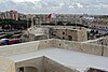 |  Upload Photo |
| Niche of the Madonna of Mount Carmel | Triq il-Karmnu / Triq San Lawrenz | 35°53′19″N 14°31′14″E / 35.888667°N 14.520639°E / 35.888667; 14.520639 (Niche of the Madonna of Mount Carmel) | 00705 | 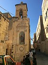 | Upload Photo |
| Church of the Madonna of Monserrat | Triq il-Madonna ta' Monserrat | 35°53′21″N 14°31′14″E / 35.889123°N 14.520585°E / 35.889123; 14.520585 (Church of the Madonna of Monserrat) | 00706 |  | Upload Photo |
| Monastery of Saint Scholastika | Triq Santa Skolastika | 35°53′20″N 14°31′20″E / 35.888948°N 14.522308°E / 35.888948; 14.522308 (Monastery of Saint Scholastika) | 00707 |  | Upload Photo |
| Niche of the Crucified Christ | Misrah ir-Rebha / Triq La Vallette | 35°53′18″N 14°31′19″E / 35.888257°N 14.522016°E / 35.888257; 14.522016 (Niche of the Crucified Christ) | 00708 | 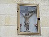 | Upload Photo |
| Niche of St. Philip Neri | Triq San Filippu / Triq Patri Indri Vella | 35°53′18″N 14°31′18″E / 35.888362°N 14.521732°E / 35.888362; 14.521732 (Niche of St. Philip Neri) | 00709 | 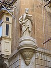 | Upload Photo |
| Church of the Madonna of the Guardian Angels | Triq San Filippu | 35°53′19″N 14°31′18″E / 35.888720°N 14.521731°E / 35.888720; 14.521731 (Church of the Madonna of the Guardian Angels) | 00710 | 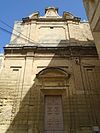 | Upload Photo |
| Statue of St. Lawrence | Misrah ir-Rebha | 35°53′17″N 14°31′20″E / 35.887921°N 14.522105°E / 35.887921; 14.522105 (Statue of St. Lawrence) | 00711 |  | Upload Photo |
| Oratory of the Fraternity of St. Joseph | Zuntier | 35°53′16″N 14°31′18″E / 35.887647°N 14.521804°E / 35.887647; 14.521804 (Oratory of the Fraternity of St. Joseph) | 00712 | 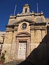 | Upload Photo |
| Oratory of the Fraternity of the Crucifix | Zuntier | 35°53′16″N 14°31′17″E / 35.887667°N 14.521509°E / 35.887667; 14.521509 (Oratory of the Fraternity of the Crucifix) | 00713 |  | Upload Photo |
| Parish Church of St. Lawrence Martyr | Triq San Lawrenz | 35°53′14″N 14°31′17″E / 35.887332°N 14.521497°E / 35.887332; 14.521497 (Parish Church of St. Lawrence Martyr) | 00714 |  | Upload Photo |
| Church of the Annunciation | Triq il-Mina l-Kbira | 35°53′13″N 14°31′20″E / 35.886954°N 14.522290°E / 35.886954; 14.522290 (Church of the Annunciation) | 00715 |  | Upload Photo |
| Houses of the Conventual Chaplains | Triq Papa Alessandru VII | 35°53′14″N 14°31′23″E / 35.887315°N 14.522924°E / 35.887315; 14.522924 (Houses of the Conventual Chaplains) | 00716 |  | Upload Photo |
| Palace of the Bishop | Triq il-Palazz ta' L-Isqof | 35°53′14″N 14°31′24″E / 35.887275°N 14.523416°E / 35.887275; 14.523416 (Palace of the Bishop) | 00717 |  | Upload Photo |
| Niche of St. Lawrence | 15 Triq il-Kwartier | 35°53′17″N 14°31′26″E / 35.887949°N 14.523830°E / 35.887949; 14.523830 (Niche of St. Lawrence) | 00718 |  | Upload Photo |
| Niche of St Joseph | Triq Gilormu Cassar / Triq Hilda Tabone | 35°53′18″N 14°31′24″E / 35.888412°N 14.523381°E / 35.888412; 14.523381 (Niche of St Joseph) | 00719 | 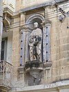 | Upload Photo |
| Niche of St. Lawrence | Triq Hilda Tabone / Triq il-Majjistral | 35°53′18″N 14°31′21″E / 35.888420°N 14.522592°E / 35.888420; 14.522592 (Niche of St. Lawrence) | 00720 |  | Upload Photo |
| Niche of the Madonna of Sorrows | Triq il-Majjistral | 35°53′17″N 14°31′22″E / 35.887987°N 14.522814°E / 35.887987; 14.522814 (Niche of the Madonna of Sorrows) | 00721 | 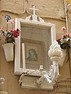 | Upload Photo |
| Niche of the Madonna of the Rosary | Triq il-Majjistral / Triq Pacifiku Scicluna | 35°53′16″N 14°31′23″E / 35.887691°N 14.523100°E / 35.887691; 14.523100 (Niche of the Madonna of the Rosary) | 00722 | 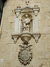 | Upload Photo |
| Niche of St. Dominic | Triq P. Boffa | 35°53′10″N 14°31′22″E / 35.886110°N 14.522901°E / 35.886110; 14.522901 (Niche of St. Dominic) | 00723 |  | Upload Photo |
| Niche of the Madonna of Sorrows | Taht il-Mina ta' Provence | 35°53′09″N 14°31′22″E / 35.885957°N 14.522741°E / 35.885957; 14.522741 (Niche of the Madonna of Sorrows) | 00724 |  | Upload Photo |
| Niche of the Crucified Christ | Couvre Porte | 35°53′08″N 14°31′21″E / 35.885439°N 14.522386°E / 35.885439; 14.522386 (Niche of the Crucified Christ) | 00725 |  | Upload Photo |
| Niche of the Face of Christ | Triq 8-ta'Dicembru (ditch) | 35°53′08″N 14°31′20″E / 35.885471°N 14.522198°E / 35.885471; 14.522198 (Niche of the Face of Christ) | 00726 |  | Upload Photo |
| Inquisitor's Palace | Triq il-Mina l-Kbira | 35°53′14″N 14°31′21″E / 35.887234°N 14.522497°E / 35.887234; 14.522497 (Inquisitor's Palace) | 01157 |  | Upload Photo |
| Auberge de France | 24-27 Triq Hilda Tabone | 35°53′19″N 14°31′22″E / 35.888523°N 14.522834°E / 35.888523; 14.522834 (Auberge de France) | 01158 |  | Upload Photo |
| Auberge d' Allemagne | 7a/7b Misrah ir-Rebha | 35°53′17″N 14°31′20″E / 35.888110°N 14.522243°E / 35.888110; 14.522243 (Auberge d' Allemagne) | 01159 | 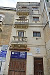 | Upload Photo |
| Auberge d' Angleterre | 40-42 Triq il-Majjistral | 35°53′18″N 14°31′21″E / 35.888219°N 14.522601°E / 35.888219; 14.522601 (Auberge d' Angleterre) | 01160 |  | Upload Photo |
| Auberge d' Aragon | 28-30 Triq Hilda Tabone | 35°53′19″N 14°31′23″E / 35.888485°N 14.522989°E / 35.888485; 14.522989 (Auberge d' Aragon) | 01161 | 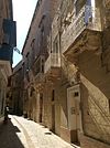 | Upload Photo |
| Auberge d' Auvergne et Provence | 21-23 Triq Hilda Tabone | 35°53′19″N 14°31′22″E / 35.888494°N 14.522707°E / 35.888494; 14.522707 (Auberge d' Auvergne et Provence) | 01162 |  | Upload Photo |
| Auberge de Castille et Portugal (leon) | 57-59 Triq Hilda Tabone / Triq Gilormu Cassar | 35°53′18″N 14°31′24″E / 35.888417°N 14.523435°E / 35.888417; 14.523435 (Auberge de Castille et Portugal (leon)) | 01163 |  | Upload Photo |
| Auberge d'Italie | 1 Triq San Lawrenz | 35°53′26″N 14°31′11″E / 35.890553°N 14.519701°E / 35.890553; 14.519701 (Auberge d'Italie) | 01164 |  | Upload Photo |
| Fort St Angelo | Xatt il-Forn | 35°53′33″N 14°31′05″E / 35.892481°N 14.518078°E / 35.892481; 14.518078 (Fort St Angelo) | 01479 | 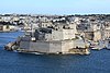 | Upload Photo |
| D' Homedes Bastion - Fort St Angelo | Sant'Anglu | 35°53′27″N 14°31′09″E / 35.890943°N 14.519097°E / 35.890943; 14.519097 (D' Homedes Bastion - Fort St Angelo) | 01480 | 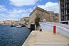 | Upload Photo |
| Cavalier - Fort St Angelo | Sant'Anglu | 35°53′30″N 14°31′08″E / 35.891593°N 14.519017°E / 35.891593; 14.519017 (Cavalier - Fort St Angelo) | 01481 | 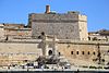 | Upload Photo |
| Curtain wall adjoining D'Homedes Bastion - Fort St Angelo | Sant'Anglu | 35°53′29″N 14°31′07″E / 35.891518°N 14.518637°E / 35.891518; 14.518637 (Curtain wall adjoining D'Homedes Bastion - Fort St Angelo) | 01482 |  | Upload Photo |
| Main Gateway - Fort St Angelo | Sant'Anglu | 35°53′29″N 14°31′07″E / 35.891476°N 14.518551°E / 35.891476; 14.518551 (Main Gateway - Fort St Angelo) | 01483 |  | Upload Photo |
| Rampart adjoining D'Homedes bastion and overlooking Moat - Fort St Angelo | Sant'Anglu | 35°53′29″N 14°31′10″E / 35.891274°N 14.519345°E / 35.891274; 14.519345 (Rampart adjoining D'Homedes bastion and overlooking Moat - Fort St Angelo) | 01484 |  | Upload Photo |
| Main enciente along No 2 battery - Fort St Angelo | Sant'Anglu | 35°53′32″N 14°31′01″E / 35.892226°N 14.517050°E / 35.892226; 14.517050 (Main enciente along No 2 battery - Fort St Angelo) | 01485 | 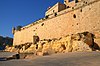 | Upload Photo |
| Sea-level (no 1) battery - Fort St Angelo | Sant'Anglu | 35°53′34″N 14°31′06″E / 35.892884°N 14.518292°E / 35.892884; 14.518292 (Sea-level (no 1) battery - Fort St Angelo) | 01486 |  | Upload Photo |
| No. 2. Battery - Fort St Angelo | Sant'Anglu | 5°53′34″N 14°31′05″E / 5.892760°N 14.518003°E / 5.892760; 14.518003 (No. 2. Battery - Fort St Angelo) | 01487 |  | Upload Photo |
| No. 3 Battery - Fort St Angelo | Sant'Anglu | 35°53′33″N 14°31′04″E / 35.892578°N 14.51774°E / 35.892578; 14.51774 (No. 3 Battery - Fort St Angelo) | 01488 | 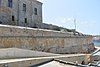 | Upload Photo |
| No. 4 Battery - Fort St Angelo | Sant'Anglu | 35°53′33″N 14°31′04″E / 35.892488°N 14.517685°E / 35.892488; 14.517685 (No. 4 Battery - Fort St Angelo) | 01489 | 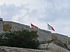 | Upload Photo |
| Castral enclosure - Fort St Angelo | Sant'Anglu | 35°53′33″N 14°31′05″E / 35.892411°N 14.518178°E / 35.892411; 14.518178 (Castral enclosure - Fort St Angelo) | 01490 | 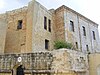 | Upload Photo |
| Barbican - Fort St Angelo | Sant'Anglu | 35°53′31″N 14°31′06″E / 35.891845°N 14.518218°E / 35.891845; 14.518218 (Barbican - Fort St Angelo) | 01491 |  | Upload Photo |
| De Guiral Battery - Fort St Angelo | Sant'Anglu | 35°53′32″N 14°31′01″E / 35.892311°N 14.516898°E / 35.892311; 14.516898 (De Guiral Battery - Fort St Angelo) | 01492 | 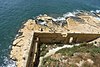 | Upload Photo |
| Gunpowder Magazine - Fort St Angelo | Sant'Anglu | 35°53′31″N 14°31′05″E / 35.891990°N 14.517925°E / 35.891990; 14.517925 (Gunpowder Magazine - Fort St Angelo) | 01493 | 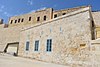 | Upload Photo |
| Sea-filled Moat - Fort St Angelo | Xatt Sant'Anglu | 35°53′28″N 14°31′10″E / 35.890982°N 14.519452°E / 35.890982; 14.519452 (Sea-filled Moat - Fort St Angelo) | 01494 | 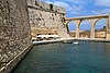 | Upload Photo |
| Entrance ramp - Fort St Angelo | Xatt Sant'Anglu | 35°53′29″N 14°31′07″E / 35.891387°N 14.518514°E / 35.891387; 14.518514 (Entrance ramp - Fort St Angelo) | 01495 | 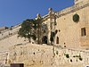 | Upload Photo |
| Birgu | Birgu | 35°53′17″N 14°31′19″E / 35.888089°N 14.522039°E / 35.888089; 14.522039 (Birgu) | 01507 |  | Upload Photo |
| St John Bastion | Triq il-Mina l-Kbira | 35°53′09″N 14°31′22″E / 35.885840°N 14.522777°E / 35.885840; 14.522777 (St John Bastion) | 01508 | 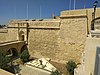 | Upload Photo |
| St John Cavalier | Triq Torri ta' San Gwann | 35°53′10″N 14°31′22″E / 35.886211°N 14.522904°E / 35.886211; 14.522904 (St John Cavalier) | 01509 |  | Upload Photo |
| French Curtain | Triq Torri ta' San Gwann | 35°53′12″N 14°31′25″E / 35.886719°N 14.523519°E / 35.886719; 14.523519 (French Curtain) | 01510 |  | Upload Photo |
| St James Bastion | Triq Torri ta' San Gwann | 35°53′13″N 14°31′28″E / 35.887024°N 14.524354°E / 35.887024; 14.524354 (St James Bastion) | 01511 |  | Upload Photo |
| St James Cavalier | Triq Torri ta' San Gwann | 35°53′14″N 14°31′27″E / 35.887217°N 14.524125°E / 35.887217; 14.524125 (St James Cavalier) | 01512 | 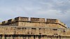 | Upload Photo |
| Post of Castile | Triq il-Foss | 35°53′17″N 14°31′29″E / 35.888107°N 14.524674°E / 35.888107; 14.524674 (Post of Castile) | 01513 | 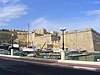 | Upload Photo |
| Hornwork of the Post of Castile | Kalkara Creek | 35°53′18″N 14°31′30″E / 35.888279°N 14.524982°E / 35.888279; 14.524982 (Hornwork of the Post of Castile) | 01514 | 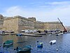 | Upload Photo |
| Retrenchment of the Post of Castile | Foss tas-Sur | 35°53′16″N 14°31′29″E / 35.887909°N 14.524625°E / 35.887909; 14.524625 (Retrenchment of the Post of Castile) | 01515 | 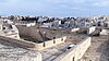 | Upload Photo |
| Enceinte along Kalkara side | il-Manderagg, Santa Skolastika | 35°53′21″N 14°31′21″E / 35.889254°N 14.522558°E / 35.889254; 14.522558 (Enceinte along Kalkara side) | 01516 |  | Upload Photo |
| Short stretch of stepped curtain wall leading down to Birgu Creek | Telghet II - Vittmi Tal-Polvrista | 35°53′09″N 14°31′20″E / 35.885800°N 14.522120°E / 35.885800; 14.522120 (Short stretch of stepped curtain wall leading down to Birgu Creek) | 01517 |  | Upload Photo |
| Couvre Porte Counterguard | Triq 8-ta'Dicembru | 35°53′07″N 14°31′21″E / 35.885240°N 14.522617°E / 35.885240; 14.522617 (Couvre Porte Counterguard) | 01518 | | Upload Photo |
| Couvre Porte Gate | Triq 8-ta'Dicembru | 35°53′08″N 14°31′21″E / 35.885429°N 14.522377°E / 35.885429; 14.522377 (Couvre Porte Gate) | 01519 | 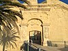 | Upload Photo |
| Covertway | il-Foss | 35°53′09″N 14°31′25″E / 35.885870°N 14.523505°E / 35.885870; 14.523505 (Covertway) | 01520 |  | Upload Photo |
| Main Ditch | il-Foss | 35°53′12″N 14°31′26″E / 35.886563°N 14.523818°E / 35.886563; 14.523818 (Main Ditch) | 01521 |  | Upload Photo |
| Battery of Ditch | il-Foss | 35°53′15″N 14°31′29″E / 35.887453°N 14.524779°E / 35.887453; 14.524779 (Battery of Ditch) | 01522 | 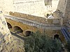 | Upload Photo |
| Advanced Gate | Saint John Bastiona | 35°53′09″N 14°31′21″E / 35.885751°N 14.522574°E / 35.885751; 14.522574 (Advanced Gate) | 01523 | 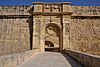 | Upload Photo |
| Main Gate | Saint John Bastion | 35°53′09″N 14°31′22″E / 35.885953°N 14.522737°E / 35.885953; 14.522737 (Main Gate) | 01524 |  | Upload Photo |
| Remains of Caponier | ditch | 35°53′11″N 14°31′26″E / 35.886484°N 14.523756°E / 35.886484; 14.523756 (Remains of Caponier) | 01525 |  | Upload Photo |
| Cottonera Lines | Cottonera | 35°52′38″N 14°31′30″E / 35.877318°N 14.525085°E / 35.877318; 14.525085 (Cottonera Lines) | 01544 | 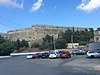 | Upload Photo |
| St Laurence Demi-bastion - Cottonera Lines | il-Mandragg | 35°53′12″N 14°31′33″E / 35.886717°N 14.525761°E / 35.886717; 14.525761 (St Laurence Demi-bastion - Cottonera Lines) | 01545 |  | Upload Photo |
| San Salvatore Curtain - Cottonera Lines | Triq Santa Liberata | 35°53′10″N 14°31′35″E / 35.886171°N 14.526329°E / 35.886171; 14.526329 (San Salvatore Curtain - Cottonera Lines) | 01546 |  | Upload Photo |
| San Salvatore Gate - Cottonera Lines | Triq Santa Liberata | 35°53′10″N 14°31′36″E / 35.886130°N 14.526558°E / 35.886130; 14.526558 (San Salvatore Gate - Cottonera Lines) | 01547 | 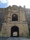 | Upload Photo |
| San Salvatore Bastion - Cottonera Lines | Triq Santa Liberata | 35°53′11″N 14°31′42″E / 35.886256°N 14.528348°E / 35.886256; 14.528348 (San Salvatore Bastion - Cottonera Lines) | 01548 | 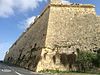 | Upload Photo |
| Fort San Salvatore - Cottonera Lines | San Salvatore Bastion | 35°53′10″N 14°31′40″E / 35.886153°N 14.527708°E / 35.886153; 14.527708 (Fort San Salvatore - Cottonera Lines) | 01549 |  | Upload Photo |
| St Louis Curtain - Cottonera Lines | Triq San Dwardu | 35°53′05″N 14°31′45″E / 35.884806°N 14.529224°E / 35.884806; 14.529224 (St Louis Curtain - Cottonera Lines) | 01550 | 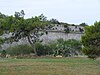 | Upload Photo |
| St Louis Gate - Cottonera Lines | Triq San Dwardu | 35°53′06″N 14°31′45″E / 35.884956°N 14.529031°E / 35.884956; 14.529031 (St Louis Gate - Cottonera Lines) | 01551 | Upload Photo | |
| St Louis Bastion - Cottonera Lines | Triq San Dwardu | 35°53′03″N 14°31′50″E / 35.884158°N 14.530510°E / 35.884158; 14.530510 (St Louis Bastion - Cottonera Lines) | 01552 |  | Upload Photo |
| St James Curtain - Cottonera Lines | Triq San Dwardu | 35°52′59″N 14°31′48″E / 35.882986°N 14.529993°E / 35.882986; 14.529993 (St James Curtain - Cottonera Lines) | 01553 | 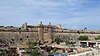 | Upload Photo |
| St James Gate - Cottonera Lines | Triq San Dwardu | 35°52′58″N 14°31′48″E / 35.882736°N 14.530001°E / 35.882736; 14.530001 (St James Gate - Cottonera Lines) | 01554 | 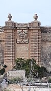 | Upload Photo |
| St James Bastion - Cottonera Lines | Triq San Dwardu | 35°52′53″N 14°31′51″E / 35.881336°N 14.530707°E / 35.881336; 14.530707 (St James Bastion - Cottonera Lines) | 01555 | 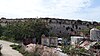 | Upload Photo |
| Notre Dame de la Grace Curtain - Cottonera Lines | Triq il-Kottonera | 35°52′48″N 14°31′45″E / 35.880000°N 14.529139°E / 35.880000; 14.529139 (Notre Dame de la Grace Curtain - Cottonera Lines) | 01556 | 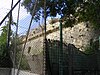 | Upload Photo |
| Notre Dame de la Grace Gate - Cottonera Lines | Triq il-Kottonera | 35°52′49″N 14°31′45″E / 35.880370°N 14.529285°E / 35.880370; 14.529285 (Notre Dame de la Grace Gate - Cottonera Lines) | 01557 | 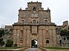 | Upload Photo |
| Notre Dame de la Grace Bastion - Cottonera Lines | Triq il-Kottonera | 35°52′44″N 14°31′45″E / 35.878890°N 14.529189°E / 35.878890; 14.529189 (Notre Dame de la Grace Bastion - Cottonera Lines) | 01558 |  | Upload Photo |
| Chapel of the Nativity of the Madonna | Sant'Anglu | 35°53′31″N 14°31′06″E / 35.891933°N 14.518310°E / 35.891933; 14.518310 (Chapel of the Nativity of the Madonna) | 01805 | 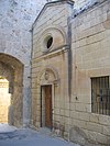 | Upload Photo |
References
- ^ "National Inventory Register". National Inventory of the Cultural Property of the Maltese Islands. 27 August 2012. Archived from the original on 12 September 2016.
- ^ "Superintendence of Cultural Property". National Inventory of the Cultural Property of the Maltese Islands. Archived from the original on 26 October 2016.
- ^ "Superintendence of Cultural Property". National Inventory of the Cultural Property of the Maltese Islands. 27 September 2013. Archived from the original on 13 February 2017.
- ^ Terribile, Tony (2000). Niċeċ u Statwi fit-Toroq Maltin. Malta: Publikazzjoni Indipendenza (PIN). ISBN 9789990941784. OCLC 48920678.


