List of covered bridges in North Carolina

Below is a list of covered bridges in North Carolina. There are only three authentic covered bridges in the U.S. state of North Carolina of which one is historic.[1] A covered bridge is considered authentic not due to its age, but by its construction. An authentic bridge is constructed using trusses rather than other methods such as stringers, a popular choice for non-authentic covered bridges.
Bridges
| Name | Image | County | Location | Built | Length | Crosses | Ownership | Truss | Notes |
|---|---|---|---|---|---|---|---|---|---|
| Bunker Hill Covered Bridge[2] |  | Catawba | Claremont 35°43′20″N 81°6′36″W / 35.72222°N 81.11000°W / 35.72222; -81.11000 (Bunker Hill Covered Bridge) | 1895 | 81 feet (25 m) | Lyle Creek | Catawba County Historical Association[3] | Haupt | Only bridge in the US using this design[1] |
| Pisgah Community Covered Bridge[2] | 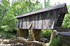 | Randolph | Pisgah 35°32′32″N 79°53′38″W / 35.54222°N 79.89389°W / 35.54222; -79.89389 (Pisgah Community Covered Bridge) | ca. 1910 | 51 feet (16 m) | Upper branch of the Little River | Private | Modified queen | |
| Will Henry Stevens Covered Bridge[4] | Macon | Highlands 35°03′24″N 83°12′18″W / 35.05667°N 83.20500°W / 35.05667; -83.20500 (Will Henry Stevens Covered Bridge) | 2008 | 87 feet (27 m) | Creek | Private | Town | Formerly the Bagley Bridge of Warner, New Hampshire |
See also
 Engineering portal
 Transportation portal
 North Carolina portal


- List of bridges on the National Register of Historic Places in North Carolina
- World Guide to Covered Bridges
References
Map all coordinates using OpenStreetMap
Download coordinates as:
- KML
- GPX (all coordinates)
- GPX (primary coordinates)
- GPX (secondary coordinates)
- ^ a b Terry E. Miller; Ronald G. Knapp; A. Chester Ong (2013). America's Covered Bridges (Kindle ed.). North Clarendon, Vermont: Tuttle Publishing. pp. 88–89. ISBN 978-1-4629-1420-3.
- ^ a b "National Register Information System". National Register of Historic Places. National Park Service. July 9, 2010.
- ^ "Bunker Hill Bridge, Spanning Lyle Creek, bypassed section of Island Ford Road, Claremont, Catawba County, NC". Historic American Engineering Record. Library of Congress. Retrieved 3 May 2020.
- ^ Caswell, William S. World Guide to Covered Bridges (2021 ed.). Concord, New Hampshire: National Society for the Preservation of Covered Bridges. p. 61. ISBN 978-0-578-30263-8.
External links
Wikimedia Commons has media related to Covered bridges in North Carolina.
- National Society for the Preservation of Covered Bridges
- Only in Your State article about the state's covered bridges
- v
- t
- e
- Alabama
- Alaska
- Arizona
- Arkansas
- California
- Colorado
- Connecticut
- Delaware
- Florida
- Georgia
- Hawaii
- Idaho
- Illinois
- Indiana
- Iowa
- Kansas
- Kentucky
- Louisiana
- Maine
- Maryland
- Massachusetts
- Michigan
- Minnesota
- Mississippi
- Missouri
- Montana
- Nebraska
- Nevada
- New Hampshire
- New Jersey
- New Mexico
- New York
- North Carolina
- North Dakota
- Ohio
- Oklahoma
- Oregon
- Pennsylvania
- Rhode Island
- South Carolina
- South Dakota
- Tennessee
- Texas
- Utah
- Vermont
- Virginia
- Washington
- West Virginia
- Wisconsin
- Wyoming


