List of Category A listed buildings in the Western Isles

Map all coordinates using OpenStreetMap
Download coordinates as:
- KML
- GPX (all coordinates)
- GPX (primary coordinates)
- GPX (secondary coordinates)
This is a list of Category A listed buildings in the Western Isles of Scotland (Scottish Gaelic: Na h-Eileanan Siar).
In Scotland, the term listed building refers to a building or other structure officially designated as being of "special architectural or historic interest".[1] Category A structures are those considered to be "buildings of national or international importance, either architectural or historic, or fine little-altered examples of some particular period, style or building type."[2] Listing was begun by a provision in the Town and Country Planning (Scotland) Act 1947, and the current legislative basis for listing is the Planning (Listed Buildings and Conservation Areas) (Scotland) Act 1997.[3] The authority for listing rests with Historic Scotland, an executive agency of the Scottish Government, which inherited this role from the Scottish Development Department in 1991. Once listed, severe restrictions are imposed on the modifications allowed to a building's structure or its fittings. Listed building consent must be obtained from local authorities prior to any alteration to such a structure.[3] There are approximately 47,400 listed buildings in Scotland, of which around 8% (or approximately 3,800) are Category A.[4]
The council area of Na h-Eileanan Siar (Western Isles) comprises an archipelago of over 100 islands and small skerries, including 14 inhabited islands with a total population of around 26,500. There are 18 Category A listed buildings on the islands, representing a variety of types and ages of structure. The 13th-century Church of St Moluag is one of three A-listed church buildings. Kisimul Castle, built on a tiny island off the shore of Castlebay, dates from the 15th century,[5] while the two other A-listed castles at Amhuinnsuidhe and Lews are Victorian. Functional architecture includes three important lighthouses, including Eilean Glas, the first lighthouse in the Western Isles. More prosaic building types are well represented, with eight traditional thatched cottages meriting Category A listing.
Listed buildings
| Name | Location | Date Listed | Grid Ref. [note 1] | Geo-coordinates | Notes | LB Number [note 2] | Image |
|---|---|---|---|---|---|---|---|
| Butt of Lewis Lighthouse | Butt of Lewis | 25/3/1971 | NB5197066483 | 58°30′56″N 6°15′39″W / 58.515625°N 6.260874°W / 58.515625; -6.260874 (Butt of Lewis Lighthouse) | Built in the 1860s and designed by David Stevenson | 5768 |  Upload another image |
| Barra Head Lighthouse | Barra Head | 5/10/1971 | NL5489880253 | 56°47′08″N 7°39′13″W / 56.785421°N 7.653546°W / 56.785421; -7.653546 (Barra Head Lighthouse) | Designed by Robert Stevenson and opened in 1833 | 5893 |  Upload another image |
| Kisimul Castle | Castlebay, Barra | 5/10/1971 | NL6651997944 | 56°57′07″N 7°29′15″W / 56.952082°N 7.487415°W / 56.952082; -7.487415 (Kisimul Castle) | 16th-century castle on an island in Castle Bay | 5901 |  Upload another image |
| St Moluag's Church (Teampull Mholuaidh) | Eoropie, Lewis | 25/3/1971 | NB5192865157 | 58°30′13″N 6°15′37″W / 58.503725°N 6.260151°W / 58.503725; -6.260151 (St Moluag's Church (Teampull Mholuaidh)) | 13th-century church | 6603 |  Upload another image |
| Amhuinnsuidhe Castle | Harris | 5/10/1971 | NB0495607806 | 57°57′41″N 6°59′26″W / 57.961378°N 6.990431°W / 57.961378; -6.990431 (Amhuinnsuidhe Castle) | 19th-century Scots baronial country house, designed by David Bryce | 12767 |  Upload another image |
| St Clement's Church | Rodel, Harris | 5/10/1971 | NG0477383184 | 57°44′27″N 6°57′47″W / 57.740937°N 6.963033°W / 57.740937; -6.963033 (St Clement's Church) | 15th-century church | 12912 |  Upload another image |
| Eilean Glas Lighthouse | Scalpay | 30/3/1994 | NG2474394715 | 57°51′25″N 6°38′31″W / 57.856854°N 6.641999°W / 57.856854; -6.641999 (Eilean Glas Lighthouse) | The first lighthouse erected in the Western Isles, built 1789 by Thomas Smith | 13487 | 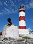 Upload another image |
| 9 Locheport | Locheport, North Uist | 5/10/1971 | NF8775863156 | 57°33′01″N 7°13′18″W / 57.550289°N 7.221786°W / 57.550289; -7.221786 (9 Locheport) | Hebridean-type thatched cottage | 17570 |  Upload Photo |
| 29 Locheport | Locheport, North Uist | 5/10/1971 | NF8491063485 | 57°33′05″N 7°16′11″W / 57.551258°N 7.269597°W / 57.551258; -7.269597 (29 Locheport) | Hebridean-type thatched cottage | 17571 | Upload Photo |
| Struan Cottage | Malaclete, North Uist | 15/1/1980 | NF7938573724 | 57°38′20″N 7°22′30″W / 57.638945°N 7.375041°W / 57.638945; -7.375041 (Struan Cottage) | Hebridean-type thatched cottage | 17582 |  Upload another image |
| Ardheisker thatched cottage | Ardheisker, North Uist | 5/10/1971 | NF7644167334 | 57°34′47″N 7°24′56″W / 57.579703°N 7.4156°W / 57.579703; -7.4156 (Ardheisker thatched cottage) | Hebridean-type thatched cottage | 17585 | Upload Photo |
| Lews Castle | Stornoway, Lewis | 25/3/1971 | NB4200933175 | 58°12′42″N 6°23′39″W / 58.211582°N 6.394058°W / 58.211582; -6.394058 (Lews Castle) | Mid 19th-century country house | 18677 |  Upload another image |
| 472b South Lochboisdale | Lochboisdale, South Uist | 15/1/1980 | NF7852817489 | 57°08′07″N 7°18′57″W / 57.135399°N 7.315826°W / 57.135399; -7.315826 (472b South Lochboisdale) | Skye-type thatched cottage | 18746 | Upload Photo |
| 77 Ardmanonie | Eochar, South Uist | 15/1/1980 | NF7731946134 | 57°23′27″N 7°22′23″W / 57.390742°N 7.37299°W / 57.390742; -7.37299 (77 Ardmanonie) | Skye-type thatched cottage | 18767 | Upload Photo |
| Lews Castle Lodges, Boundary Walls, Sea Walls and Tower | Stornoway, Lewis | 25/3/1971 | NB4213133002 | 58°12′36″N 6°23′30″W / 58.210104°N 6.391796°W / 58.210104; -6.391796 (Lews Castle Lodges, Boundary Walls, Sea Walls and Tower) | 19th-century walls around Lews Castle | 19206 | Upload Photo |
| St Columba's Church (Eye Church) | Aignish, Lewis | 25/3/1971 | NB4846932260 | 58°12′26″N 6°17′00″W / 58.207119°N 6.283444°W / 58.207119; -6.283444 (St Columba's Church (Eye Church)) | Late medieval church, now partly ruined | 19210 | 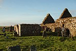 Upload another image |
| Bualadubh | Eochar, South Uist | 15/1/1980 | NF7882346166 | 57°23′32″N 7°20′53″W / 57.392092°N 7.34812°W / 57.392092; -7.34812 (Bualadubh) | Skye-type thatched cottage | 19908 | Upload Photo |
| North Beach Quay/North Beach Old Sail Loft | North Beach, Stornoway, Lewis | 25/3/1971 | NB4211932816 | 58°12′30″N 6°23′30″W / 58.208431°N 6.391794°W / 58.208431; -6.391794 (North Beach Quay/North Beach Old Sail Loft) | Large 19th-century warehouse with adjoining house | 41735 |  Upload another image |
Notes
- ^ Sometimes known as OSGB36, the grid reference (where provided) is based on the British national grid reference system used by the Ordnance Survey.
• "Guide to National Grid". Ordnance Survey. Retrieved 12 December 2007.
• "Get-a-map". Ordnance Survey. Retrieved 17 December 2007. - ^ Historic Environment Scotland assign a unique alphanumeric identifier to each designated site in Scotland, for listed buildings this always begins with "LB", for example "LB12345".
References
- ^ Guide to the Protection of Scotland’s Listed Buildings (PDF). Historic Scotland. 2009. p. 4. ISBN 978-1-84917-013-0. Retrieved 5 May 2010.
- ^ "What is Listing?". Historic Scotland. Retrieved 5 May 2010.
- ^ a b Scottish Historic Environment Policy (PDF). Historic Scotland. October 2008. pp. 24–25. ISBN 978-1-84917-002-4. Retrieved 5 May 2010.
- ^ Guide to the Protection of Scotland’s Listed Buildings, p. 17.
- ^ "Kisimul Castle, Listed Building Report". Historic Scotland. Retrieved 10 May 2010.
External links
![]() Media related to Category A listed buildings in Na h-Eileanan Siar at Wikimedia Commons
Media related to Category A listed buildings in Na h-Eileanan Siar at Wikimedia Commons
- v
- t
- e
- City of Aberdeen
- Aberdeenshire
- Angus
- Argyll and Bute
- Clackmannanshire
- Dumfries and Galloway
- City of Dundee
- East Ayrshire
- East Dunbartonshire
- East Lothian
- East Renfrewshire
- City of Edinburgh
- Falkirk
- Fife
- City of Glasgow
- Highland
- Inverclyde
- Midlothian
- Moray
- North Ayrshire
- North Lanarkshire
- Orkney
- Perth and Kinross
- Renfrewshire
- Scottish Borders
- Shetland
- South Ayrshire
- South Lanarkshire
- Stirling
- West Dunbartonshire
- West Lothian
- Western Isles (na h-Eileanan Siar)
Settlements and places of interest in the Outer Hebrides (Na h-Eileanan Siar) | ||
|---|---|---|
| on Lewis and Harris |  | |
| on North Uist, Benbecula and South Uist |
| |
| on Barra | ||
| Places of interest | ||


