Klostertal
You can help expand this article with text translated from the corresponding article in German. (April 2018) Click [show] for important translation instructions.
- View a machine-translated version of the German article.
- Machine translation, like DeepL or Google Translate, is a useful starting point for translations, but translators must revise errors as necessary and confirm that the translation is accurate, rather than simply copy-pasting machine-translated text into the English Wikipedia.
- Consider adding a topic to this template: there are already 9,129 articles in the main category, and specifying
|topic=will aid in categorization. - Do not translate text that appears unreliable or low-quality. If possible, verify the text with references provided in the foreign-language article.
- You must provide copyright attribution in the edit summary accompanying your translation by providing an interlanguage link to the source of your translation. A model attribution edit summary is
Content in this edit is translated from the existing German Wikipedia article at [[:de:Klostertal]]; see its history for attribution. - You may also add the template
{{Translated|de|Klostertal}}to the talk page. - For more guidance, see Wikipedia:Translation.
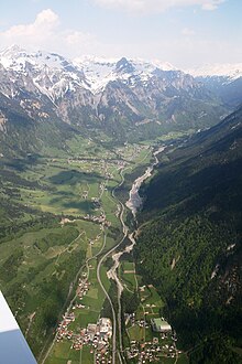
The Klostertal is an alpine valley in Vorarlberg, in Austria. It branches off at Bludenz and extends about 30 kilometers to the east to the Arlberg and the border with Tyrol. It consists of the three communities of Klösterle am Arlberg, Dalaas and Innerbraz and the three Bludenz towns Bings, Radin and Außerbraz with an area of 193.6 km ² and about 4,700 inhabitants (as of 2017).[1]
The valley opens to the east of the district capital Bludenz and is characterized by the south and north steeply towering mountain ranges of the Lechquellen Mountains and the Verwalls mountain range. The Alfenz flows through the Klostertal from Stuben am Arlberg (district of Klösterle/ Arlberg) to the Ill at Bludenz. The bottom of the valley is rising steadily, which is reflected by the fact that the sea level of the settlement areas ranges between 600 m in the west and 1,400 m in the east.
History
The name Klostertal can be explained historically with the transfer of the chapel in St. Marienthal by Count Hugo I. von Montfort in 1218 to the Johanniterhaus in Feldkirch. In return for the foundation received, the Order of St. John had to give at least shelter, fire and water to the passing poor people. For this purpose, a hospice was built, which was called Klösterle, just like the evolving town around the hospice. Later the whole valley was called Klostertal, which replaced the former name St. Marienthal.
The shortest connection between Tyrol and Vorarlberg leads over the 1793 m high Arlbergpass. Over the centuries, this connection has been used by business, military and other travelers. The weather determined the length of this crossing and so along the route a number of utilities such as guest houses and accommodations.[2]
References
External links
 Media related to Klostertal at Wikimedia Commons
Authority control databases | |
|---|---|
| International |
|
| National |
|


