Kita-ku, Kumamoto
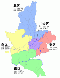

Kita-ku (北区) is one of the five wards of Kumamoto City, Japan. Meaning literally "north ward," it is bordered by the Nishi-ku, Chūō-ku, Higashi-ku and also by the cities of Yamaga, Kikuchi, Kōshi and the towns of Gyokutō and Kikuyō. As of 2012, it has a population of 140,684 people and an area of 115.65 km2.
External links
![]() Media related to Kita-ku, Kumamoto at Wikimedia Commons
Media related to Kita-ku, Kumamoto at Wikimedia Commons
- v
- t
- e
 Kumamoto Prefecture
Kumamoto (capital)
| Wards |
|---|

32°54′13″N 130°41′40″E / 32.90361°N 130.69444°E / 32.90361; 130.69444
| Authority control databases: Geographic |
|
|---|
 | This Kumamoto Prefecture location article is a stub. You can help Wikipedia by expanding it. |
- v
- t
- e


