Kehtna Parish
Municipality of Estonia
Municipality of Estonia in Rapla County
Kehtna Parish Kehtna vald | |
|---|---|
Municipality of Estonia | |
 Kehtna church in Lellapere | |
 Flag  Coat of arms | |
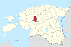 Kehtna Parish within Rapla County. | |
| Country |  Estonia Estonia |
| County |  Rapla County Rapla County |
| Administrative centre | Kehtna |
| Area | |
| • Total | 512 km2 (198 sq mi) |
| Population (01.01.2019) | |
| • Total | 5,469 |
| • Density | 11/km2 (28/sq mi) |
| ISO 3166 code | EE-293 |
| Website | www |
Kehtna Parish (Estonian: Kehtna vald) is a rural municipality in central Estonia.[1] It is a part of Rapla County. The municipality has a population of 5,182 (as of 1 January 2004) and covers an area of 507.3 km2. The population density is 10.2 inhabitants per km2.
Settlements
- Boroughs
- Small boroughs
Administrative centre of the municipality is Kehtna small borough. The other small boroughs are Eidapere, Kaerepere, Keava and Lelle.
- Villages
Also there are also 43 villages: Ahekõnnu - Ellamaa - Haakla - Hertu - Hiie - Ingliste - Käbiküla - Kaerepere - Kalbu - Kärpla - Kehtna-Nurme - Kastna - Kenni - Koogimäe - Koogiste - Kõrbja - Kumma - Laeste - Lalli - Lau - Lellapere - Lellapere-Nurme - Linnaaluste - Lokuta - Metsaääre - Mukri - Nadalama - Nõlva - Ohekatku - Pae - Palasi - Paluküla - Põllu - Põrsaku - Reonda - Rõue - Saarepõllu - Saksa - Saunaküla - Selja - Sooaluste - Valtu-Nurme - Vastja.
Religion
Religion in Kethna Parish (2021) [1]
Unaffiliated (82.7%)
Lutheran (10.4%)
Orthodox (2.4%)
Others Christians (2.00%)
Others Religions (0.6%)
Unknown (1.9%)
References
- ^ "X-GIS(3) Portal". xgis.maaamet.ee. Retrieved 31 January 2022.
External links
 Media related to Kehtna Parish at Wikimedia Commons
- Official website (available only in Estonian)
- Kehtna Basic School (available only in Estonian)
- Kehtna School of Economy and Technology (available only in Estonian)


58°55′49″N 24°52′41″E / 58.93028°N 24.87806°E / 58.93028; 24.87806
 | This Rapla County location article is a stub. You can help Wikipedia by expanding it. |
- v
- t
- e


