Jôf di Montasio
Mountain in Italy


Jôf di Montasio
Location in the Alps
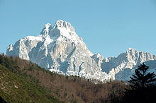
The Jôf di Montasio (Italian, Friulian: Jôf dal Montâs, Slovene: Montaž, German: Montasch) is a mountain located in the Province of Udine, in the Friuli-Venezia Giulia region of northeastern Italy.
With its elevation of 2,752 metres (9,029 ft), it is the second highest mountain of the Julian Alps, surpassed only by Triglav. The Julian Alps are part of the Southern Limestone Alps System.
History
Since medieval times, the steep rocks of the Montasio massif, stretching about 20 kilometres (12 mi) in an east–west direction, formed the natural border between the Imperial Duchy of Carinthia in the north and the Venetian Domini di Terraferma in the south. In World War I the mountain crest up to the Sella Nevea pass was part of the Italian Front and permanently manned by the Alpini. However, no hostilities happened here as the northern slope of the mountain was too steep for an attack by the Austro-Hungarian Army.
Culture
In the valleys around the mountain, local people speak four languages - Italian, Friulian, Slovene, and German. The original German name for the mountain was Bramkofel, while the original Slovene name was Špik nad Policami or Poliški Špik. However nowadays they mostly use Montasch and Montaž, borrowed from the Friulian name.
At the top of the mountain stands a cross and a bell in memory of Riccardo Deffar.
Climbing routes
There are many climbing routes from all sides. Many of them are hard rock climbing routes and ferratas, in particular from the north-east side. The normal mountaineering route is from the south side. It passes the Rifugio Brazza, at round 1650 m above the sea level. After that you can choose either the direction towards the Pipan ladder, or towards Findenegg Couloir and Suringar bivouac which is at 2400 m above the sea level.
The Ladder is 60 meters long steel structure and you should have ferrata equipment. Some sections in the Findenegg Couloir route are a bit exposed, and you also have some simple scramble at several places above the Suringar bivouac.
See also
- List of Alpine peaks by prominence
- Mountains of the Alps
References
- ^ a b c "Europe Ultra-Prominences". Peaklist.org. Retrieved 2012-10-30.
- ^ Mag. Hermann von Findenegg (Findenig) Der Erstbesteiger des Montasch
External links
- Jôf di Montasio/Montaž at Hribi.net
- "Jôf di Montasio, Italy" on Peakbagger
- Jof di Montasio (Montaz) - Route description on Mountains for Everybody
- v
- t
- e
- Spain: Mulhacén
- Aneto
- Torre de Cerredo
- Almanzor — Massif Central: Puy de Sancy
- Canaries: Teide
- Roque de los Muchachos
- Pico de las Nieves
- Malpaso — Azores: Pico
- Madeira: Ruivo
- Mont Blanc
- Grossglockner
- Finsteraarhorn
- Wildspitze
- Bernina
- Hochkönig
- Dufourspitze
- Hoher Dachstein
- Marmolada
- Viso
- Triglav
- Barre des Écrins
- Säntis
- Ortler
- Baldo
- Gran Paradiso
- Coca
- Cima Dodici
- Dents du Midi
- Chamechaude
- Zugspitze
- Antelao
- Arcalod
- Grintovec
- Großer Priel
- Grigna Settentrionale
- Bondone
- Presanella
- Birnhorn
- Col Nudo
- Pointe Percée
- Jôf di Montasio
- Polinik
- Tödi
- Birkkarspitze
- Ellmauer Halt
- Grande Tête de l'Obiou
- Hochtor
- Grimming
- Grand Combin
- Tournette
- Zirbitzkogel
- Kesch
- Cima Brenta
- Corno Grande
- Amaro
- Serra Dolcedorme
- Montalto
- Cimone
- Carpathians: Gerlachovský štít
- Parângu Mare
- Moldoveanu
- Peleaga
- Pietrosul Rodnei — Crimea: Roman-Kosh — Urals: Narodnaya
- Musala
- Olympus
- Vihren
- Taygetus
- Korab
- Jezercë
- Athos
- Kyllini
- Ossa
- Papingu
- Pangaion Hills
- Kajmakčalan
- Smolikas
- Giona
- Jakupica
- Këndrevica
- Radomir
- Parnassus
- Botev
- Çika
- Valamara
- Baba
- Psili Koryfi
| Authority control databases |
|
|---|
 | This article on a location in Friuli-Venezia Giulia is a stub. You can help Wikipedia by expanding it. |
- v
- t
- e
 | This Italian location article is a stub. You can help Wikipedia by expanding it. |
- v
- t
- e


