Horus Temple
Summit in the Grand Canyon, Arizona


Horus.Temple
Location in Arizona
Show map of Arizona
Horus.Temple
Horus.Temple (the United States)
Show map of the United StatesCoconino County, Arizona, US
Colorado Plateau
sandstone, shale, siltstone, mudstone, limestone
on slopes of Hermit Formation (shale) debris,
upon platform of resistant cliff-former Esplanade Sandstone and
Coconino Sandstone-caprock,
Hermit Formation,
Esplanade Sandstone-platform-(Supai Group, unit 4 of 4),
Supai Group,
Redwall Limestone,
Muav Limestone,
Bright Angel Shale, Tapeats Sandstone
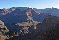
Horus Temple is a 6,150 ft elevation summit located in the Grand Canyon, in Coconino County of Arizona, Southwestern United States. This butte is situated as the central landform in a 3-series line of peaks southwest of the Shiva Temple (forested)-tableland prominence.
Geology
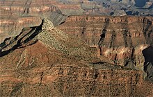
The top of Horus Temple is a flat ~north-south platform composed of the reddish Pennsylvanian-Permian Supai Group.[4] The 69th unit and uppermost unit of the Supai Group is the extremely resistant Esplanade Sandstone. At the north end of this platform is the butte’s prominence, an extremely fractured remnant, of cliff-former Coconino Sandstone capstone, upon a small slope of slope-forming, deep brown-red Hermit Formation.
The Supai Group sits on the resistant cliff-forming, typically massive Redwall Limestone, (as in the connected Tower of Set southwards). The base of the Redwall has a short, but resistant cliff of (3rd-unit) Muav Limestone. Below the Muav are units 2 and 1 of the 3-unit Tonto Group, the colorful dull-greenish Bright Angel Shale, and dp-brown Tapeats Sandstone.
Gallery
-
 Horus Temple, aerial view from west
 -
 (Viewed from southeast)
Tower of Set peak-(center)
Horus Temple prominence-(extreme left)
Shiva Temple (Grand Canyon), forested tableland summit on the left horizon
(photo note: Tower of Set, has the 2 closer prominences) -
 Osiris Temple left, and Horus Temple right. Aerial view from west.


References
- ^ a b c "Horus Temple – 6,150' AZ". Lists of John. Retrieved January 5, 2021.
- ^ U.S. Geological Survey Geographic Names Information System: Horus Temple
- ^ Circular of General Information Regarding Grand Canyon National Park Arizona, 1928, U.S. Government Printing Office, page 63.
- ^ N.H. Darton, Story of the Grand Canyon of Arizona, 1917, pp. 12, 37.


