Grebenstein
Town in Hesse, Germany

Coat of arms
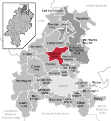
Location of Grebenstein within Kassel district
(2022–28) Danny Sutor[1]
(2022-12-31)[2]
34393
Grebenstein (German pronunciation: [ˈɡʁeːbm̩ˌʃtaɪ̯n] ⓘ) is a town in the district of Kassel, in Hesse, Germany. It is located 16 km northwest of Kassel on the German Timber-Frame Road. In 1762 it was the scene of a skirmish between British and French troops during the Seven Years' War.
Gallery
-
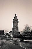 One of the historic towers on the town wall
 -
 Parish church, 2005


References
External links
- City's Homepage (in German)
Wikimedia Commons has media related to Grebenstein, Germany.
- v
- t
- e
Towns and municipalities in Kassel district
- Ahnatal
- Bad Emstal
- Bad Karlshafen
- Baunatal
- Breuna
- Calden
- Espenau
- Fuldabrück
- Fuldatal
- Grebenstein
- Habichtswald
- Helsa
- Hofgeismar
- Immenhausen
- Kaufungen
- Liebenau
- Lohfelden
- Naumburg
- Nieste
- Niestetal
- Reinhardshagen
- Schauenburg
- Söhrewald
- Trendelburg
- Vellmar
- Wesertal
- Wolfhagen
- Zierenberg

Authority control databases | |
|---|---|
| International |
|
| National |
|
| Geographic |
|
 | This Hesse location article is a stub. You can help Wikipedia by expanding it. |
- v
- t
- e


